37.77.185.157 - IP Lookup: Free IP Address Lookup, Postal Code Lookup, IP Location Lookup, IP ASN, Public IP
Country:
Region:
City:
Location:
Time Zone:
Postal Code:
IP information under different IP Channel
ip-api
Country
Region
City
ASN
Time Zone
ISP
Blacklist
Proxy
Latitude
Longitude
Postal
Route
Luminati
Country
ASN
Time Zone
America/Chicago
ISP
AS-SSI
Latitude
Longitude
Postal
IPinfo
Country
Region
City
ASN
Time Zone
ISP
Blacklist
Proxy
Latitude
Longitude
Postal
Route
IP2Location
37.77.185.157Country
Region
england
City
winchester
Time Zone
Europe/London
ISP
Language
User-Agent
Latitude
Longitude
Postal
db-ip
Country
Region
City
ASN
Time Zone
ISP
Blacklist
Proxy
Latitude
Longitude
Postal
Route
ipdata
Country
Region
City
ASN
Time Zone
ISP
Blacklist
Proxy
Latitude
Longitude
Postal
Route
Popular places and events near this IP address

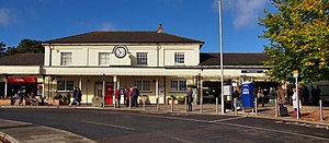
Winchester railway station
Railway station in Hampshire, England
Distance: Approx. 230 meters
Latitude and longitude: 51.067,-1.32
Winchester railway station serves the city of Winchester, in the county of Hampshire, England. It is a stop on the South West Main Line and was known as Winchester City from 1949–67, to distinguish it from Winchester (Chesil) station. It is 66 miles 39 chains (107.0 km) down the line from London Waterloo.

Royal Green Jackets (Rifles) Museum
Regimental museum in Peninsula Barracks, Winchester
Distance: Approx. 289 meters
Latitude and longitude: 51.062954,-1.321023
The Royal Green Jackets (Rifles) Museum is situated at Peninsula Barracks in Winchester, England. The museum is one of several regimental museums that form part of Winchester's Military Museums.

Venta Belgarum
Town in Roman Britannia
Distance: Approx. 262 meters
Latitude and longitude: 51.063,-1.317
Venta Belgarum, or Venta Bulgarum, was a town in the Roman province of Britannia Superior, the civitas capital of the local tribe, the Belgae, and which later became the city of Winchester.

Winchester Law Courts
Judicial building in Winchester, England
Distance: Approx. 291 meters
Latitude and longitude: 51.0625,-1.3191
The Winchester Law Courts is a judicial facility just off the High Street in Winchester, Hampshire, England. As well as accommodating the Crown Court, which deals with criminal cases, the complex also accommodates the County Court and the Winchester District Registry of the High Court.

Oram's Arbour
Iron Age settlement in Hampshire, England
Distance: Approx. 237 meters
Latitude and longitude: 51.06468611,-1.32201667
Oram's Arbour was an enclosed settlement (oppidum) during the Iron Age, in what is now Winchester, England. Limited dating evidence suggests the enclosure was dug in the early-mid first century BC. The town wall of the Roman civitas capital of Venta Belgarum which succeeded the Iron Age settlement cut across its eastern end. Today it is a small grassy park in Winchester, and was formerly used for the annual Winchester Hat Fair both as a picnic site and to stage outdoor theatre and acrobatics.
Westgate, Winchester
Distance: Approx. 180 meters
Latitude and longitude: 51.0635,-1.3191
The Westgate is one of two surviving fortified gateways in Winchester, England (the other is Kingsgate) formerly part of Winchester City Walls. The earliest surviving fabric is of Anglo-Saxon character. The gate was rebuilt in the 12th century and modified in the 13th and late 14th centuries, the latter including a portcullis in the western façade and two inverted-keyhole gunports (for use with hand-held cannon), the earliest in the country.

Hampshire Archives and Local Studies
Distance: Approx. 178 meters
Latitude and longitude: 51.0667,-1.3186
Hampshire Archives and Local Studies holds the archives for the county of Hampshire. The archives are located in Sussex Street, Winchester, and are run by Hampshire County Council.

Castle Hill, Winchester
County building in Winchester, Hampshire, England
Distance: Approx. 187 meters
Latitude and longitude: 51.0635,-1.3195
Castle Hill is a series of buildings used as council offices in Winchester, Hampshire, England. There are two main structures both of which are Grade II listed buildings: the Castle Hill Offices on the east of Castle Avenue and the Castle Avenue Offices on the west of Castle Avenue. They take their name from Winchester Castle, which is located at the south end of Castle Avenue.

St Peter's Church, Winchester
Church in Winchester, United Kingdom
Distance: Approx. 213 meters
Latitude and longitude: 51.06499,-1.31566
St Peter's Church is a Roman Catholic church in Winchester, England. It was built in 1924 and designed by Frederick Walters in the Gothic revival style. It is situated on Jewry Street, backing onto St Peter's Street, next to Milner Hall, in the centre of Winchester.

The Rifles Museum
Regimental museum in Winchester, United Kingdom
Distance: Approx. 310 meters
Latitude and longitude: 51.0628,-1.3212
The Rifles Museum is the regimental museum of The Rifles. It is located in Winchester in Hampshire, England and is part of Winchester's Military Museums.
Winchester United Church
Church in Hampshire , United Kingdom
Distance: Approx. 197 meters
Latitude and longitude: 51.064,-1.3165
Winchester United Church (originally Winchester Congregational Church and later Winchester United Reformed Church) is a joint United Reformed and Methodist church in the centre of the city of Winchester in the English county of Hampshire. Built between 1852 and 1853 to the Gothic Revival design of architects Poulton and Woodman for a congregation which had its origins nearly 200 years earlier, it is "incongruously set within the northern part of the former county jail", which had recently moved to a new site. Since 1974 the congregation has been a joint United Reformed and Methodist one, as the city's two Methodist chapels closed, the congregations merged and worship was concentrated on the one site.

Corn Exchange, Winchester
Commercial building in Winchester, Hampshire, England
Distance: Approx. 176 meters
Latitude and longitude: 51.0653,-1.3162
The Corn Exchange, also known as The Arc, is a commercial building in Jewry Street in Winchester, Hampshire, England. The structure, which is currently used as a cultural hub, is a Grade II* listed building.
Weather in this IP's area
scattered clouds
5 Celsius
3 Celsius
5 Celsius
6 Celsius
1011 hPa
94 %
1011 hPa
1005 hPa
10000 meters
2.57 m/s
230 degree
40 %

