37.77.155.192 - IP Lookup: Free IP Address Lookup, Postal Code Lookup, IP Location Lookup, IP ASN, Public IP
Country:
 Poland
Region:
City:
Location:
Time Zone:
Postal Code:
ISP:
ASN:
language:
User-Agent:
Proxy IP:
Blacklist:
IP information under different IP Channel
ip-api
Country
Region
City
ASN
Time Zone
ISP
Blacklist
Proxy
Latitude
Longitude
Postal
Route
db-ip
Country
Region
City
ASN
Time Zone
ISP
Blacklist
Proxy
Latitude
Longitude
Postal
Route
IPinfo
Country
Region
City
ASN
Time Zone
ISP
Blacklist
Proxy
Latitude
Longitude
Postal
Route
IP2Location
37.77.155.192Country
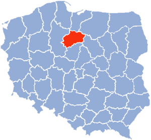
plRegion
kujawsko-pomorskie
City
torun
Time Zone
Europe/Warsaw
ISP
Language
User-Agent
Latitude
Longitude
Postal
ipdata
Country
Region
City
ASN
Time Zone
ISP
Blacklist
Proxy
Latitude
Longitude
Postal
Route
Popular places and events near this IP address
Toruń Voivodeship
Former administrative division of Poland
Distance: Approx. 589 meters
Latitude and longitude: 53.018569,18.601561
Toruń Voivodeship (Polish: województwo toruńskie) was a unit of administrative division and local government in Poland in the years 1975–1998, superseded by the Kuyavian-Pomeranian Voivodeship. Its capital city was Toruń.

Toruń Cathedral
Church in Toruń, Poland
Distance: Approx. 730 meters
Latitude and longitude: 53.009264,18.60613
The Cathedral Basilica of St. John the Baptist and St. John the Evangelist (Polish: Bazylika katedralna św.

Pomeranian Voivodeship (1919–1939)
Former voivodeship of Poland
Distance: Approx. 647 meters
Latitude and longitude: 53.011288,18.606882
The Pomeranian Voivodeship or Pomorskie Voivodeship (Polish: Województwo Pomorskie) was an administrative unit of Interwar poland (from 1919 to 1939). It ceased to function in September 1939, following the German and Soviet invasion of Poland. Most of the territory of Pomeranian province became part of the current Kuyavian-Pomeranian Voivodeship, of which one of two capitals is the same as the interwar voivodeship's Toruń; the second one is Bydgoszcz.

Roman Catholic Diocese of Toruń
Roman Catholic diocese in Poland
Distance: Approx. 730 meters
Latitude and longitude: 53.009264,18.60613
The Diocese of Toruń (Latin: Dioecesis Thoruniensis) is a Latin Church ecclesiastical territory or diocese of the Catholic Church located in the city of Toruń in the ecclesiastical province of Gdańsk in Poland.

District Museum in Toruń
Regional museum in Toruń, Poland
Distance: Approx. 531 meters
Latitude and longitude: 53.01083333,18.60444444
Toruń Regional Museum (Polish: Muzeum Okręgowe w Toruniu), located in the Ratusz hall of Toruń, is one of the oldest and largest museums in Poland. It started in 1594 as the mere Cabinet of Curiosities at the library of the academic Gimnazjum, called Musaeum in Latin. Re-established in sovereign Poland as a city museum in 1920 after the century of military partitions, it was administratively structured as the regional museum in 1965.

Living Museum of Gingerbread
Food museum in Rabiańska , Toruń
Distance: Approx. 719 meters
Latitude and longitude: 53.00861111,18.60472222
Żywe Muzeum Piernika (English: Living Museum of Gingerbread) is a hands-on experience tourist attraction located in medieval old town of Toruń, Poland, that is famous for its gingerbread. Visitors take part in an interactive show through which they are taught how to make a traditional gingerbread. The show consist of two parts – first visitors are shown how the dough was made in Middle Ages.

Nicolaus Copernicus Monument, Toruń
Monument in Poland
Distance: Approx. 599 meters
Latitude and longitude: 53.01027778,18.605
The Nicolaus Copernicus Monument in the home town of astronomer Nicolaus Copernicus (1473–1543) was erected in 1853 by a "monument committee" of the city's residents.

Siege of Toruń (1658)
Distance: Approx. 659 meters
Latitude and longitude: 53.01111111,18.60694444
The siege of Toruń was one of the battles during the Swedish invasion of Polish–Lithuanian Commonwealth (Second Northern War / Deluge). It started on 2 July 1658 and ended on 30 December 1658. Swedish garrison capitulated and Toruń returned to Polish hands.

Leaning Tower of Toruń
Fortified tower in Toruń, Poland
Distance: Approx. 656 meters
Latitude and longitude: 53.00834444,18.6022
The Leaning Tower of Toruń (Polish: Krzywa Wieża w Toruniu) is a medieval tower in Toruń, Poland. It is known as a leaning tower because the top of the tower is displaced 1.5 metres (4 ft 11 in) from where it would be if the tower were perfectly vertical. Located on Pod Krzywą Wieżą street, it is one of the most important landmarks in Toruń's Old Town.

National Laboratory of Atomic, Molecular and Optical Physics
National inter-university research center in Poland
Distance: Approx. 518 meters
Latitude and longitude: 53.0172,18.6032
National Laboratory of Atomic, Molecular and Optical Physics (KL FAMO) is the national inter-university research center with the headquarters at Institute of Physics of Nicolaus Copernicus University in Toruń, Poland. Established in 2002, the Laboratory is focused on atomic, molecular, and optical physics (AMO).
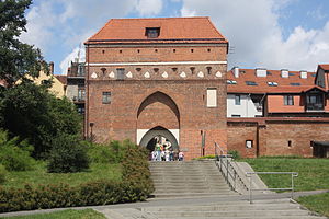
Monastery Gate in Toruń
Medieval gate in Toruń, Poland
Distance: Approx. 708 meters
Latitude and longitude: 53.00826,18.60359
The Monastery Gate in Toruń also the Gate of the Holy Spirit or the Gate of the Lady - one of the three gates of medieval Toruń that have survived to this day.

Old Town City Hall in Toruń
Medieval seat of the municipal authorities of Toruń
Distance: Approx. 553 meters
Latitude and longitude: 53.01044,18.60434
The Old Town City Hall in Toruń is the main secular building of Toruń's Old Town, a Gothic building created in stages during the 13th and 14th centuries, reconstructed in the 17th century and rebuilt after destruction in the 18th century, one of the most outstanding examples of medieval city architecture in central Europe, the main seat of the District Museum in Toruń.
Weather in this IP's area
overcast clouds
2 Celsius
2 Celsius
2 Celsius
4 Celsius
1039 hPa
97 %
1039 hPa
1031 hPa
10000 meters
0.45 m/s
0.45 m/s
89 degree
100 %