Country:
Region:
City:
Latitude and Longitude:
Time Zone:
Postal Code:
IP information under different IP Channel
ip-api
Country
Region
City
ASN
Time Zone
ISP
Blacklist
Proxy
Latitude
Longitude
Postal
Route
Luminati
Country
Region
62
City
ronciglione
ASN
Time Zone
Europe/Rome
ISP
Mordacchini Srl
Latitude
Longitude
Postal
IPinfo
Country
Region
City
ASN
Time Zone
ISP
Blacklist
Proxy
Latitude
Longitude
Postal
Route
db-ip
Country
Region
City
ASN
Time Zone
ISP
Blacklist
Proxy
Latitude
Longitude
Postal
Route
ipdata
Country
Region
City
ASN
Time Zone
ISP
Blacklist
Proxy
Latitude
Longitude
Postal
Route
Popular places and events near this IP address

Sutri
Comune in Lazio, Italy
Distance: Approx. 7994 meters
Latitude and longitude: 42.23333333,12.28333333
Sutri (Latin Sutrium) is an Ancient town, modern comune and former bishopric (now a Latin titular see) in the province of Viterbo, about 50 kilometres (31 mi) from Rome and about 30 kilometres (19 mi) south of Viterbo. It is picturesquely situated on a narrow tuff hill, surrounded by ravines, a narrow neck on the west alone connecting it with the surrounding country. It is one of I Borghi più belli d'Italia ("The most beautiful villages of Italy").

Villa Farnese
Mansion in Caprarola, Italy
Distance: Approx. 4770 meters
Latitude and longitude: 42.3288285,12.2367984
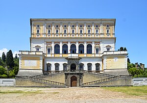
The Villa Farnese, also known as Villa Caprarola, is a pentagonal mansion in the town of Caprarola in the province of Viterbo, Northern Lazio, Italy, approximately 50 kilometres (31 mi) north-west of Rome, originally commissioned and owned by the House of Farnese. A property of the Republic of Italy, Villa Farnese is run by the Polo Museale del Lazio. This villa is not to be confused with two similarly-named properties of the family, the Palazzo Farnese and the Villa Farnesina, both in Rome.

Monti Cimini
Mountain range in Italy
Distance: Approx. 8579 meters
Latitude and longitude: 42.3582,12.1777
The Monti Cimini, in English: Cimini Hills, are a range of densely wooded volcanic hills approximately 56 km (35 mi) north-west of Rome. They are part of the Antiapennine range, facing the Apennines main range towards the Tyrrhenian Sea. They are situated in the centre of Tuscia Viterbese, the highest point at Mount Cimino, 1,053 m (3,455 ft) above sea level.
Bassano Romano
Comune in Lazio, Italy
Distance: Approx. 8478 meters
Latitude and longitude: 42.21666667,12.18333333
Bassano Romano is a town and comune situated in the hills of Monti Sabatini in the province of Viterbo, in northern Lazio (Italy). With its origins about 1000 as the agricultural hamlet of Bassano di Sutri the village's future was founded in 1160 by the wealthy landowner Enotrio Serco, who initiated the construction at the top of the slope of a fortified residence that over the centuries became a princely dwelling, frescoed by famous artists. In 1482 Pope Sixtus IV assigned the Foedus Bassani to the Anguillara, Roman patricians (patrizii di Roma).
Capranica, Lazio
Comune in Lazio, Italy
Distance: Approx. 6089 meters
Latitude and longitude: 42.25,12.16666667
Capranica (Capranichese: Caprà) is a comune (municipality) in the Province of Viterbo in the Italian region Lazio, located about 55 kilometres (34 mi) northwest of GRA (Grande Raccordo Anulare, Rome's orbital motorway), 66 kilometres (41 mi) from Rome’s centre, and 24.5 kilometres (15.2 mi) southeast of Viterbo.
Carbognano
Comune in Lazio, Italy
Distance: Approx. 4048 meters
Latitude and longitude: 42.31666667,12.25
Carbognano is a comune (municipality) in the Province of Viterbo in the Italian region of Latium, located about 50 kilometres (31 mi) northwest of Rome and about 15 kilometres (9 mi) southeast of Viterbo. As of 31 December 2004, it had a population of 1,992 and an area of 17.2 square kilometres (6.6 sq mi). Carbognano borders the following municipalities: Caprarola, Fabrica di Roma, Nepi, Vallerano.
Fabrica di Roma
Comune in Lazio, Italy
Distance: Approx. 7266 meters
Latitude and longitude: 42.33333333,12.28333333
Fabrica di Roma is a comune (municipality) in the Province of Viterbo in the Italian region of Latium, located about 55 kilometres (34 mi) northwest of Rome and about 25 kilometres (16 mi) south-east of Viterbo. Fabrica di Roma borders the following municipalities: Carbognano, Castel Sant'Elia, Civita Castellana, Corchiano, Nepi, Vallerano, Vignanello.

Lake Vico
Volcanic crater lake in Lazio, Italy
Distance: Approx. 5448 meters
Latitude and longitude: 42.31666667,12.16666667
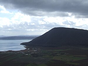
Lake Vico (Italian: lago di Vico, pronounced [ˈviːko]) is a caldera lake in northern Lazio, central Italy. It is one of the highest major Italian lakes, with an altitude of 510 m. Administratively, it is part of the municipalities of Caprarola and Ronciglione.
Roman Catholic Diocese of Bagnoregio
Distance: Approx. 5203 meters
Latitude and longitude: 42.24127778,12.22622222
The Diocese of Bagnoregio is a former Catholic territory, located in the modern Province of Viterbo in the Italian region of Lazio, located about 90 kilometres (56 mi) northwest of Rome. Prior to the creation of the Kingdom of Italy, it belonged to the Papal States, and was located in the region of Umbria. It had been given to the Papal States by the Emperor Louis I in 822.
Biblioteca Teresiana
Public library in Mantua, Italy
Distance: Approx. 4537 meters
Latitude and longitude: 42.32676,12.23628
The Biblioteca Teresiana (est. 1780) of Mantua, Italy, is a public library founded by sovereign Maria Theresa.
1991 World Cup (men's golf)
Golf tournament
Distance: Approx. 7994 meters
Latitude and longitude: 42.23333333,12.28333333
The 1991 World Cup took place 31 October – 3 November 1991 at the Le Querce Golf Club, name later changed to Golf Nazionale, 30 miles north of Rome, Italy. It was the 37th World Cup event. The tournament was a 72-hole stroke play team event with 32 teams.
Weather in this IP's area
few clouds
6 Celsius
4 Celsius
6 Celsius
7 Celsius
1022 hPa
71 %
1022 hPa
973 hPa
10000 meters
2.47 m/s
4.93 m/s
360 degree
15 %
07:02:09
16:49:37


