Country:
Region:
City:
Latitude and Longitude:
Time Zone:
Postal Code:
IP information under different IP Channel
ip-api
Country
Region
City
ASN
Time Zone
ISP
Blacklist
Proxy
Latitude
Longitude
Postal
Route
Luminati
Country
Region
hb
City
bremen
ASN
Time Zone
Europe/Berlin
ISP
LWLcom GmbH
Latitude
Longitude
Postal
IPinfo
Country
Region
City
ASN
Time Zone
ISP
Blacklist
Proxy
Latitude
Longitude
Postal
Route
db-ip
Country
Region
City
ASN
Time Zone
ISP
Blacklist
Proxy
Latitude
Longitude
Postal
Route
ipdata
Country
Region
City
ASN
Time Zone
ISP
Blacklist
Proxy
Latitude
Longitude
Postal
Route
Popular places and events near this IP address

Böttcherstraße
Street in Bremen, Germany
Distance: Approx. 856 meters
Latitude and longitude: 53.075,8.80555556
Böttcherstraße is a street in the historic centre of Bremen, Germany. Only about 100 m (330 ft) long, it is famous for its unusual architecture and ranks among the city's main cultural landmarks and visitor attractions. Most of its buildings were erected between 1922 and 1931, primarily as a result of the initiative of Ludwig Roselius, a Bremen-based coffee-trader, who charged Bernhard Hoetger with the artistic supervision over the project.

Shipper's House in Bremen
Historic building in Bremen, Germany
Distance: Approx. 826 meters
Latitude and longitude: 53.07305556,8.80861111
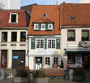
The Shipper's House in Bremen, Germany is a building in the oldest district of the Free Hanseatic city of Bremen. The house was registered as an historical monument in 1973 and is in Schnoor. During the last 25 years of the 20th century the house was a private museum.

Kleine Weser and Werdersee
Lake in Germany
Distance: Approx. 687 meters
Latitude and longitude: 53.06583333,8.80833333
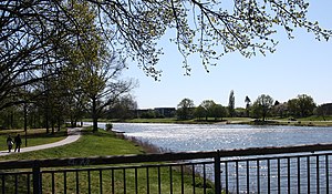
Until 1968 the Kleine Weser and the Werdersee were part of the river Weser in Bremen, Germany.

St. Martin's Church, Bremen
Distance: Approx. 812 meters
Latitude and longitude: 53.075,8.80416667
The St. Martin's Church (German: St. Martini) is a Protestant church in the old town of Bremen.
Schlachte Great Crane
Distance: Approx. 853 meters
Latitude and longitude: 53.07571667,8.80280278
The Schlachte Cranes were important to the port of Bremen as they enabled heavy loads to be moved off boats on the River Weser. The Schlachte became an important harbour for the city after silting prevented the use of the Balge as a harbour. Today, only the foundations of a 19th-century crane remain on the Weser waterfront.

Glockenspiel House
Building in Bremen, Germany
Distance: Approx. 865 meters
Latitude and longitude: 53.075,8.80583333
The Glockenspiel House (German: Haus des Glockenspiels) is a building in Bremen in the north of Germany. With its 30 bells of Meissen porcelain, the carillon (Glockenspiel) chimes three times a day while wooden panels depicting pioneering seafarers and aviators appear on a rotating mechanism inside the tower.

Atlantis House
Distance: Approx. 829 meters
Latitude and longitude: 53.07472222,8.80555556
The Atlantis House (German: Haus Atlantis) on Böttcherstraße in the old town of Bremen in the north of Germany is an interesting example of German architecture in the interwar period. Designed by Bernhard Hoetger, it was completed in 1931. After suffering serious war damage, it was rebuilt in 1965 with a new facade designed by Ewald Mataré.

Robinson Crusoe House
Stepped-gabled house on Böttcherstraße in Bremen, Germany
Distance: Approx. 810 meters
Latitude and longitude: 53.07472222,8.805
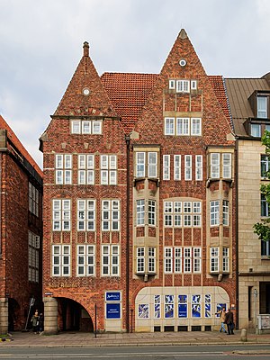
Robinson Crusoe House (German: Robinson-Crusoe-Haus) is a stepped-gabled house on Böttcherstraße in the old town district of Bremen, Germany. It was built by the prosperous coffee merchant Ludwig Roselius who admired the pioneering spirit of Daniel Defoe's fictional hero Robinson Crusoe.

St Petrus House
Historic building in Bremen, Germany
Distance: Approx. 856 meters
Latitude and longitude: 53.075,8.80555556
St Petrus House (German: Haus St. Petrus) is a historic building in Bremen, Germany. With features of North-German Gothic architecture including an arcade, it was built in 1927 by the prosperous coffee merchant Ludwig Roselius as part of his development of Böttcherstraße.

St. John's Church, Bremen
Distance: Approx. 852 meters
Latitude and longitude: 53.07369,8.80821
St. John's Church (German: St. Johann) is a Roman Catholic provost church in Bremen.

Olbers-Planetarium
Planetarium in Bremen, Germany
Distance: Approx. 647 meters
Latitude and longitude: 53.06997222,8.80830556
The Olbers-Planetarium is located in the Free Hanseatic City of Bremen, Germany, recording about 29.000 visitors a year. It was named after Heinrich Wilhelm Olbers (1758 – 1840), a doctor and astronomer from Bremen.

Maritime Rescue Coordination Centre Bremen
Distance: Approx. 618 meters
Latitude and longitude: 53.07084,8.8073
The Maritime Rescue Coordination Centre Bremen (Deutsch: Seenotleitstelle Bremen) is responsible for coordinating air-sea rescue for the German sea-area of North Sea and Baltic Sea. It covers a shoreline of 3.660 km length and is owned and operated by German Maritime Search and Rescue Service at their headquarters in the Hanseatic City of Bremen. The MRCC works along with the Central Command for Maritime Emergencies (CCME) in Cuxhaven.
Weather in this IP's area
clear sky
8 Celsius
6 Celsius
6 Celsius
9 Celsius
1029 hPa
84 %
1029 hPa
1028 hPa
10000 meters
2.57 m/s
290 degree
07:26:53
16:49:46
