Country:
 Germany
Region:
City:
Latitude and Longitude:
Time Zone:
Postal Code:
IP information under different IP Channel
ip-api
Country
Region
City
ASN
Time Zone
ISP
Blacklist
Proxy
Latitude
Longitude
Postal
Route
Luminati
Country
DERegion
hb
City
bremen
ASN
Time Zone
Europe/Berlin
ISP
LWLcom GmbH
Latitude
Longitude
Postal
IPinfo
Country
Region
City
ASN
Time Zone
ISP
Blacklist
Proxy
Latitude
Longitude
Postal
Route
db-ip
Country
Region
City
ASN
Time Zone
ISP
Blacklist
Proxy
Latitude
Longitude
Postal
Route
ipdata
Country
Region
City
ASN
Time Zone
ISP
Blacklist
Proxy
Latitude
Longitude
Postal
Route
Popular places and events near this IP address
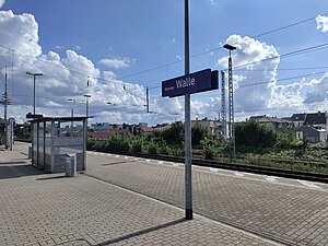
Bremen-Walle station
Railway station in Walle, Germany
Distance: Approx. 1833 meters
Latitude and longitude: 53.1043,8.7858
Bremen-Walle is a railway station in Bremen, Germany on the Bremen–Bremerhaven line. It is situated in the Walle district northwest of the city centre and the central station. The station only offers local services; it is a regular stop for the Verden to Bremen-Vegesack trains, with additional peak time services to and from Bremerhaven.

Bremen TV tower
Distance: Approx. 1374 meters
Latitude and longitude: 53.09583333,8.79194444
Bremen-Walle Telecommunication Tower (official designation of Bremen TV tower), which is not accessible for the public, is, like the telecommunication tower at Münster and the Friedrich-Clemens-Gerke Tower in Cuxhaven, a reproduction of the telecommunication tower Kiel. It is 235.70 meters high. The diameter of the operating pulpit, which is 108.20 meters above ground, is 40 meters.

University of the Arts Bremen
Art school in Bremen, Germany
Distance: Approx. 1081 meters
Latitude and longitude: 53.09805556,8.7675
The University of the Arts Bremen (German: Hochschule für Künste Bremen, HfK Bremen) is a public university in Bremen, Germany. It is one of the most successful arts institutions, and its origins date back to 1873. The University of the Arts Bremen runs a Faculty of Fine Arts and Design, and a Faculty of Music, with approximately 900 students, 65 professors and about 180 assistant professors.

Weser Tower
Multistorey building in Bremen, Germany
Distance: Approx. 1065 meters
Latitude and longitude: 53.08333333,8.78694444
The Weser Tower is a multistorey building in Bremen.

Bremen Neustadt station
Railway station in Bremen, Germany
Distance: Approx. 1674 meters
Latitude and longitude: 53.07588,8.7858
Bremen Neustadt (German: Bahnhof Bremen Neustadt) is a railway station located in Bremen, Germany. The station is located on the Oldenburg–Bremen railway. The train services are operated by NordWestBahn.

Weserburg
Modern art museum in Bremen, Germany
Distance: Approx. 2174 meters
Latitude and longitude: 53.07638889,8.79888889
The Weserburg is a modern art museum in Bremen, Germany. Opened in 1991, it is located on the Teerhof peninsula next to the River Weser in an old factory building which was almost completely destroyed in the Second World War. Originally known as "New Museum Weserburg Bremen" (Neues Museum Weserburg Bremen), it was Europe's first "collectors' museum", in that it conserves no permanent collection but mounts changing exhibition of private collections.

Schlachte (Bremen)
Promenade along the east bank of the River Weser in Germany
Distance: Approx. 2365 meters
Latitude and longitude: 53.07611111,8.80222222
The Schlachte is a promenade along the east bank of the River Weser in the old town of Bremen in the north of Germany. Once one of the city's harbours, it is now popular for its restaurants, beer gardens and river boats.

Teerhof
Peninsula between the River Weser and the Kleine Weser in Germany
Distance: Approx. 2174 meters
Latitude and longitude: 53.07638889,8.79888889
The Teerhof is a peninsula between the River Weser and the Kleine Weser, opposite the city centre of Bremen, Germany. It was first mentioned in 1624 as "Theerhof" when it was the northernmost part of an island. Today it consists mainly of residential buildings and the Weserburg modern art museum.

Suding & Soeken building, Bremen
Building in Bremen, Germany
Distance: Approx. 2323 meters
Latitude and longitude: 53.07694444,8.8025
The Suding & Soeken building (German: Kontorhaus Suding und Soeken) is a gabled house at No. 28 Langenstraße in Bremen, Germany. Referred to as a Kaufmannshaus or Kontorhaus, it is one of the city's few historic merchant houses to survive the war undamaged.
Die Küste (Bremen)
Former entertainment district in Bremen, Germany
Distance: Approx. 980 meters
Latitude and longitude: 53.09801,8.7766
Die Küste (English: The Coast) was the former entertainment district at the Port of Bremen in Bremen, Germany. Die Küste evolved at the exit of the free port (Überseestadt) on the Nordstraße. It was linked to the Walle district by a foot tunnel, the Stinkbüdelmannsgang.

St. Ansgarii Church
Distance: Approx. 2267 meters
Latitude and longitude: 53.078468,8.803213
St. Ansgarii Church was a medieval Brick Gothic church in Bremen. The 97-meter-high tower was the tallest landmark of the city for centuries.
Missler concentration camp
Distance: Approx. 1929 meters
Latitude and longitude: 53.0935,8.8025
Missler concentration camp, also known as KZ Mißler in German, was an early concentration camp operating in Nazi Germany. The concentration camp was set up at the end of March 1933. Under orders of SS-Hauptsturmführer Otto Löblich, 148 prisoners, of which most were persecuted communists, were to be held in "protective custody".
Weather in this IP's area
overcast clouds
8 Celsius
5 Celsius
7 Celsius
9 Celsius
1027 hPa
95 %
1027 hPa
1026 hPa
10000 meters
4.63 m/s
130 degree
100 %
07:28:57
16:47:57