Country:
 France
Region:
City:
Latitude and Longitude:
Time Zone:
Postal Code:
IP information under different IP Channel
ip-api
Country
Region
City
ASN
Time Zone
ISP
Blacklist
Proxy
Latitude
Longitude
Postal
Route
IPinfo
Country
Region
City
ASN
Time Zone
ISP
Blacklist
Proxy
Latitude
Longitude
Postal
Route
MaxMind
Country
Region
City
ASN
Time Zone
ISP
Blacklist
Proxy
Latitude
Longitude
Postal
Route
Luminati
Country
FRRegion
idf
City
neuillysurseine
ASN
Time Zone
Europe/Paris
ISP
ADISTA SAS
Latitude
Longitude
Postal
db-ip
Country
Region
City
ASN
Time Zone
ISP
Blacklist
Proxy
Latitude
Longitude
Postal
Route
ipdata
Country
Region
City
ASN
Time Zone
ISP
Blacklist
Proxy
Latitude
Longitude
Postal
Route
Popular places and events near this IP address

Neuilly-sur-Seine
Commune in Île-de-France, France
Distance: Approx. 446 meters
Latitude and longitude: 48.8881,2.2686
Neuilly-sur-Seine (French pronunciation: [nøji syʁ sɛn] ; lit. 'Neuilly-on-Seine'), also known simply as Neuilly, is an urban commune in the Hauts-de-Seine department just west of Paris in France. Immediately adjacent to the city, north of the Bois de Boulogne, the area is composed of mostly select residential neighbourhoods, as well as many corporate headquarters and a handful of foreign embassies.

Compagnies Républicaines de Sécurité
French riot police
Distance: Approx. 640 meters
Latitude and longitude: 48.8925,2.2775
The Compagnies républicaines de sécurité (French: [kɔ̃paɲi ʁepyblikɛn də sekyʁite], Republican Security Corps), abbreviated CRS, are the general reserve of the French National Police. They are primarily involved in general security missions, but the task for which they are best known is crowd and riot control. The DCCRS has seven units: in Paris, Lille, Rennes, Bordeaux, Marseille, Lyon and Metz.

Les Sablons station
Metro station in Paris, France
Distance: Approx. 717 meters
Latitude and longitude: 48.88083333,2.27222222
Les Sablons (French pronunciation: [le sablɔ̃]) is a station on Line 1 of the Paris Métro in the commune of Neuilly-sur-Seine west of the city. In 2019 Les Sablons ranked 53rd in passenger volume among the system's 302 stations. The station is located under Avenue Charles de Gaulle, a major traffic artery between Etoile and La Defense.

American Hospital of Paris
Hospital in Paris, France
Distance: Approx. 662 meters
Latitude and longitude: 48.8929,2.2725
The American Hospital of Paris (Hôpital américain de Paris), founded in 1906, is a private, not-for-profit, community hospital certified under the French healthcare system. Located in Neuilly-sur-Seine, in the western suburbs of Paris, France, it has 187 surgical, medical, and obstetric beds.
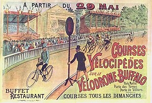
Vélodrome Buffalo and Stade Buffalo
Velodrome in Paris, France
Distance: Approx. 678 meters
Latitude and longitude: 48.88527778,2.28333333
The Vélodrome Buffalo and Stade Buffalo were cycling tracks in Paris. The first existed from 1892 until World War I. The second from 1922 until 1957. The name derives from the showman Buffalo Bill Cody, whose circus played on the grounds of the first velodrome.
Marymount International School, Paris
School in Neuilly-sur-Seine, France
Distance: Approx. 691 meters
Latitude and longitude: 48.89236111,2.2695
Marymount International School Paris in Neuilly-sur-Seine, France is an international school in the Paris metropolitan area and is part of the Religious of the Sacred Heart of Mary network of Marymount schools. The history of Marymount Paris can be traced back to 1846 when Father Jean Gailhac founded an order of Sisters in Béziers in the south of France. The objective, considered a progressive idea at that time, was the education of young women.

Lycée Pasteur (Neuilly-sur-Seine)
Distance: Approx. 119 meters
Latitude and longitude: 48.88611111,2.27388889
The Lycée Pasteur (French: Lycée Pasteur de Neuilly-sur-Seine) is a French state-run secondary school in Neuilly-sur-Seine, on the outskirts of Paris. It accepts students from collège (the first four years of secondary education in France) through to classes préparatoires (classes to prepare students for entrance to the elite Grandes écoles). Built in the grounds of the former chateau de Neuilly, the lycée is named in honour of Louis Pasteur.

Liceo Español Luis Buñuel
Spanish international lycée school in France
Distance: Approx. 327 meters
Latitude and longitude: 48.8879,2.2788
Liceo Español Luis Buñuel (LELB, Spanish Lycee “Luis Buñuel", French: Lycée Espagnol Luis Buñuel) is a Spanish international school in Neuilly-sur-Seine, France, in the Paris metropolitan area. Operated by the Spanish Ministry of Education, the school has secundaria obligatoria (required lower secondary school) courses and bachillerato (Spanish baccalaureate, non-compulsory) education. The Colegio Español Federico García Lorca, the Paris-area Spanish international primary school, is located in the 16th arrondissement of Paris.

Avenue Charles-de-Gaulle (Neuilly-sur-Seine)
Distance: Approx. 789 meters
Latitude and longitude: 48.8831,2.2656
The Avenue Charles-de-Gaulle is an avenue in Neuilly-sur-Seine, Paris, France, named after Charles de Gaulle. The avenue forms part of the Route nationale 13. Until 1971, it was called the Avenue de Neuilly, a rare case in France where the road bears the name of the commune in which it is found.
Canton of Neuilly-sur-Seine
Administrative division of Hauts-de-Seine, France
Distance: Approx. 461 meters
Latitude and longitude: 48.89,2.27
The canton of Neuilly-sur-Seine is an administrative division of the Hauts-de-Seine department, in northern France. It was created at the French canton reorganisation which came into effect in March 2015. Its seat is in Neuilly-sur-Seine.

Hertford British Hospital
Distance: Approx. 540 meters
Latitude and longitude: 48.89013,2.28027
The Hertford British Hospital was a hospital founded in Paris in 1871 for British and other English-speaking patients. In 2008, it merged with a nearby French hospital and was renamed to Hôpital franco-britannique. The Hertford British Hospital building was designed by Ernest-Paul Sanson and is a protected national monument.

Institution Notre-Dame de Sainte-Croix
Private Catholic school in Paris
Distance: Approx. 323 meters
Latitude and longitude: 48.88878639,2.27809194
The Institution Notre-Dame de Sainte-Croix, often called Sainte-Croix de Neuilly, is a Roman Catholic educational institution under contract with the State, located in Neuilly-sur-Seine in the Hauts-de-Seine department in France.
Weather in this IP's area
clear sky
12 Celsius
11 Celsius
10 Celsius
12 Celsius
1015 hPa
91 %
1015 hPa
1010 hPa
10000 meters
3.6 m/s
200 degree
08:17:40
18:53:37