Country:
 France
Region:
City:
Latitude and Longitude:
Time Zone:
Postal Code:
IP information under different IP Channel
ip-api
Country
Region
City
ASN
Time Zone
ISP
Blacklist
Proxy
Latitude
Longitude
Postal
Route
IPinfo
Country
Region
City
ASN
Time Zone
ISP
Blacklist
Proxy
Latitude
Longitude
Postal
Route
MaxMind
Country
Region
City
ASN
Time Zone
ISP
Blacklist
Proxy
Latitude
Longitude
Postal
Route
Luminati
Country
FRRegion
pdl
City
mamers
ASN
Time Zone
Europe/Paris
ISP
ADISTA SAS
Latitude
Longitude
Postal
db-ip
Country
Region
City
ASN
Time Zone
ISP
Blacklist
Proxy
Latitude
Longitude
Postal
Route
ipdata
Country
Region
City
ASN
Time Zone
ISP
Blacklist
Proxy
Latitude
Longitude
Postal
Route
Popular places and events near this IP address
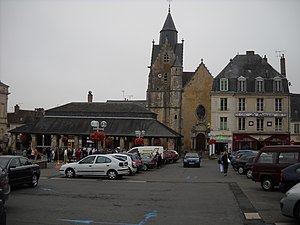
Mamers
Subprefecture and commune in Pays de la Loire, France
Distance: Approx. 343 meters
Latitude and longitude: 48.3517,0.3678
Mamers (French: [mamɛʁs] ) is a commune in the Sarthe department in the region of Pays de la Loire in north-western France. The neighboring communes are: Commerveil, Saint-Longis, Saint-Rémy-des-Monts, Origny-le-Roux, Suré. Mamers is twinned with the town Market Rasen in Lincolnshire, England.

Arrondissement of Mamers
Arrondissement in Pays de la Loire, France
Distance: Approx. 545 meters
Latitude and longitude: 48.35,0.36666667
The arrondissement of Mamers is an arrondissement of France in the Sarthe department in the Pays de la Loire region. It has 191 communes. Its population is 150,238 (2016), and its area is 2,904.9 km2 (1,121.6 sq mi).

Origny-le-Roux
Commune in Normandy, France
Distance: Approx. 3847 meters
Latitude and longitude: 48.3456,0.4211
Origny-le-Roux (French pronunciation: [ɔʁiɲi lə ʁu] ) is a commune in the Orne department in north-western France.

Suré
Commune in Normandy, France
Distance: Approx. 2714 meters
Latitude and longitude: 48.3697,0.3989
Suré (French pronunciation: [syʁe] ) is a commune in the Orne department in north-western France.

Chemilli
Commune in Normandy, France
Distance: Approx. 5592 meters
Latitude and longitude: 48.3644,0.4447
Chemilli (French pronunciation: [ʃəmiji] ) is a commune in the Orne department in north-western France.
Commerveil
Commune in Pays de la Loire, France
Distance: Approx. 4250 meters
Latitude and longitude: 48.3169,0.3578
Commerveil (French pronunciation: [kɔmɛʁvɛj]) is a commune in the Sarthe department in the Pays de la Loire region in north-western France.
Saint-Rémy-des-Monts
Commune in Pays de la Loire, France
Distance: Approx. 5527 meters
Latitude and longitude: 48.3086,0.4006
Saint-Rémy-des-Monts (French pronunciation: [sɛ̃ ʁemi de mɔ̃]) is a commune in the Sarthe department in the region of Pays de la Loire in north-western France.
Saint-Longis
Commune in Pays de la Loire, France
Distance: Approx. 1847 meters
Latitude and longitude: 48.3553,0.3458
Saint-Longis is a commune in the Sarthe department in the region of Pays de la Loire in north-western France.
Contilly
Commune in Pays de la Loire, France
Distance: Approx. 5266 meters
Latitude and longitude: 48.4014,0.3694
Contilly is a commune in the Sarthe department in the Pays de la Loire region in north-western France.
Marollette
Commune in Pays de la Loire, France
Distance: Approx. 2295 meters
Latitude and longitude: 48.3705,0.3519
Marollette (French pronunciation: [maʁɔlɛt]) is a commune in the Sarthe department in the region of Pays de la Loire in north-western France.

Pizieux
Commune in Pays de la Loire, France
Distance: Approx. 4604 meters
Latitude and longitude: 48.3222,0.3311
Pizieux (French pronunciation: [pizjø]) is a commune in the Sarthe department in the region of Pays de la Loire in north-western France.
Canton of Mamers
Distance: Approx. 459 meters
Latitude and longitude: 48.35,0.37
The canton of Mamers is an administrative division of the Sarthe department, northwestern France. Its borders were modified at the French canton reorganisation which came into effect in March 2015. Its seat is in Mamers.
Weather in this IP's area
overcast clouds
11 Celsius
10 Celsius
11 Celsius
11 Celsius
1014 hPa
92 %
1014 hPa
999 hPa
10000 meters
4.14 m/s
10.28 m/s
189 degree
96 %
08:24:27
19:02:04