Country:
 France
Region:
City:
Latitude and Longitude:
Time Zone:
Postal Code:
IP information under different IP Channel
ip-api
Country
Region
City
ASN
Time Zone
ISP
Blacklist
Proxy
Latitude
Longitude
Postal
Route
IPinfo
Country
Region
City
ASN
Time Zone
ISP
Blacklist
Proxy
Latitude
Longitude
Postal
Route
MaxMind
Country
Region
City
ASN
Time Zone
ISP
Blacklist
Proxy
Latitude
Longitude
Postal
Route
Luminati
Country
FRASN
Time Zone
Europe/Paris
ISP
ADISTA SAS
Latitude
Longitude
Postal
db-ip
Country
Region
City
ASN
Time Zone
ISP
Blacklist
Proxy
Latitude
Longitude
Postal
Route
ipdata
Country
Region
City
ASN
Time Zone
ISP
Blacklist
Proxy
Latitude
Longitude
Postal
Route
Popular places and events near this IP address
Isle (river)
River in France
Distance: Approx. 588 meters
Latitude and longitude: 44.91555556,-0.24916667
The Isle (French pronunciation: [il] ; Occitan: Eila) is a 255-kilometre (158 mi) long river in south-western France, right tributary of the Dordogne. Its source is in the north-western Massif Central, near the town Nexon (south of Limoges). It flows south-west through the following départements and towns: Haute-Vienne: Le Chalard Dordogne: Périgueux, Mussidan Gironde: Libourne It flows into the Dordogne in Libourne.

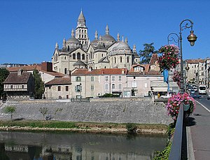
Libourne
Subprefecture and commune in Nouvelle-Aquitaine, France
Distance: Approx. 630 meters
Latitude and longitude: 44.92,-0.24
Libourne (French pronunciation: [libuʁn] ; Gascon: Liborna [liˈbuɾnɔ]) is a commune in the Gironde department in Nouvelle-Aquitaine in southwestern France. It is a sub-prefecture of the department. It is the wine-making capital of northern Gironde and lies near Saint-Émilion and Pomerol.

Arrondissement of Libourne
Arrondissement in Nouvelle-Aquitaine, France
Distance: Approx. 1749 meters
Latitude and longitude: 44.9,-0.23333333
The arrondissement of Libourne is an arrondissement of France in the Gironde department in the Nouvelle-Aquitaine region. It has 129 communes. Its population is 154,067 (2016), and its area is 1,282.9 km2 (495.3 sq mi).
Stade Jean-Antoine Moueix
Distance: Approx. 996 meters
Latitude and longitude: 44.907354,-0.234253
Stade Jean-Antoine Moueix is a multi-use stadium in Libourne, France. It is currently used mostly for football matches and is the home stadium of FC Libourne-Saint-Seurin. The stadium is able to hold 8,500 people.

Fronsac, Gironde
Commune in Nouvelle-Aquitaine, France
Distance: Approx. 2648 meters
Latitude and longitude: 44.925,-0.272
Fronsac (French pronunciation: [fʁɔ̃sak]; Occitan: Fronçac) is a commune in the Gironde department in the Nouvelle-Aquitaine region in southwestern France. The town gave its name to the Fronsac AOC wine.
Château Le Pin
Distance: Approx. 3133 meters
Latitude and longitude: 44.92583,-0.20548
Château Le Pin, or simply Le Pin, is a Bordeaux wine from the appellation Pomerol. The unusually small estate is located on the Right Bank of France's Gironde estuary in the commune of Pomerol in the hamlet of Catusseau, and its wine is frequently one of the world's most expensive red wines.
Château Trotanoy
Pomerol winery
Distance: Approx. 3138 meters
Latitude and longitude: 44.92938,-0.20804
Château Trotanoy, archaically Trop Ennuie, is a Bordeaux wine from the appellation Pomerol. The winery is located on the Right Bank of the Bordeaux wine region, in the commune of Pomerol in the department Gironde. As all wine produced in this appellation, Château Trotanoy is unclassified, but the estate is estimated among the great growths of the region.
Château Quinault
Distance: Approx. 1551 meters
Latitude and longitude: 44.90078,-0.23845
Château Quinault is a winery from the appellation Saint-Émilion within the city of Libourne, producing Quinault L'Enclos, a Bordeaux wine counted among the Bordeaux Right Bank "supercuvées" or "vins de garage". The estate also produces a second wine, Lafleur de Quinault, and a special cuvée called L'Absolut de Quinault.
Château Mazeyres
Bordeaux wine
Distance: Approx. 2096 meters
Latitude and longitude: 44.93257,-0.2344
Château Mazeyres is a Bordeaux wine from the appellation Pomerol. The winery is located on the Right Bank of the Bordeaux wine region, in the commune of Pomerol in the department Gironde. As all wine produced in this appellation, Château Mazeyres is unclassified but the estate is estimated among the great growths of the region.

Libourne station
Distance: Approx. 454 meters
Latitude and longitude: 44.9158,-0.2364
The gare de Libourne is a railway interchange station in Libourne, Nouvelle-Aquitaine, France. The station is located on the Paris - Bordeaux, Bordeaux - Bergerac - Sarlat, Bordeaux - Coutras - Périgueux (Line 24 for Limoges and 25 for Brive) and Bordeaux - Angoulême railway lines.

Ponty vineyards
Distance: Approx. 2702 meters
Latitude and longitude: 44.920751,-0.274984
Ponty Vineyards, also known as Vignobles Ponty, is a wine estate of Bordeaux wine in the Canon Fronsac appellation located on the right bank of the river Garonne, 25 km away from Bordeaux, close to the city of Libourne. Close to the Pomerol and Saint-Emilion regions, Canon Fronsac’s landscape of plateaus and hills snuggle into the confluence of two rivers: the Isle and the Dordogne. Winemaking has been the family business for the Ponty family for more than five generations.
Canton of Le Libournais-Fronsadais
Distance: Approx. 522 meters
Latitude and longitude: 44.91,-0.24
The canton of Le Libournais-Fronsadais is an administrative division of the Gironde department, southwestern France. It was created at the French canton reorganisation which came into effect in March 2015. Its seat is in Libourne.
Weather in this IP's area
light rain
14 Celsius
14 Celsius
14 Celsius
14 Celsius
1018 hPa
83 %
1018 hPa
1016 hPa
10000 meters
3.08 m/s
6.29 m/s
185 degree
100 %
08:21:56
19:09:29