Country:
 France
Region:
City:
Latitude and Longitude:
Time Zone:
Postal Code:
IP information under different IP Channel
ip-api
Country
Region
City
ASN
Time Zone
ISP
Blacklist
Proxy
Latitude
Longitude
Postal
Route
IPinfo
Country
Region
City
ASN
Time Zone
ISP
Blacklist
Proxy
Latitude
Longitude
Postal
Route
MaxMind
Country
Region
City
ASN
Time Zone
ISP
Blacklist
Proxy
Latitude
Longitude
Postal
Route
Luminati
Country
FRASN
Time Zone
Europe/Paris
ISP
ADISTA SAS
Latitude
Longitude
Postal
db-ip
Country
Region
City
ASN
Time Zone
ISP
Blacklist
Proxy
Latitude
Longitude
Postal
Route
ipdata
Country
Region
City
ASN
Time Zone
ISP
Blacklist
Proxy
Latitude
Longitude
Postal
Route
Popular places and events near this IP address

Montargis
Subprefecture and commune in Centre-Val de Loire, France
Distance: Approx. 323 meters
Latitude and longitude: 47.9978,2.7333
Montargis (French pronunciation: [mɔ̃taʁʒi]) is a commune in the Loiret department, Centre-Val de Loire, France. Montargis is the seventh most populous commune in the Centre-Val de Loire région, and the second in the Loiret département after Orléans. It is near a large forest, and contains light industry and farming, including saffron.

Arrondissement of Montargis
Arrondissement in Centre-Val de Loire, France
Distance: Approx. 489 meters
Latitude and longitude: 48,2.73333333
The arrondissement of Montargis is an arrondissement of France in the Loiret department in the Centre-Val de Loire region. It has 125 communes. Its population is 170,285 (2016), and its area is 2,657.2 km2 (1,026.0 sq mi).

Puiseaux (river)
River in France
Distance: Approx. 630 meters
Latitude and longitude: 47.99916667,2.72972222
The Puiseaux is a small river in the Loiret department, central France, left tributary of the Loing. It is 37.1 km (23.1 mi) long. Its source is in the commune of Les Choux.

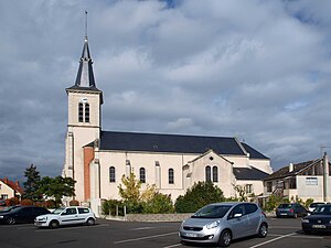
Châlette-sur-Loing
Commune in Centre-Val de Loire, France
Distance: Approx. 1793 meters
Latitude and longitude: 48.0125,2.7364
Châlette-sur-Loing (French pronunciation: [ʃalɛt syʁ lwɛ̃]) is a commune in the Loiret department in north-central France.
Villemandeur
Commune in Centre-Val de Loire, France
Distance: Approx. 2092 meters
Latitude and longitude: 47.9908,2.7103
Villemandeur (French pronunciation: [vilmɑ̃dœʁ]) is a commune in the Loiret department in north-central France.

Amilly, Loiret
Commune in Centre-Val de Loire, France
Distance: Approx. 3523 meters
Latitude and longitude: 47.9742,2.7708
Amilly (French pronunciation: [amiji] or [amili]) is a commune and town in the Loiret department in north-central France.
Solin (river)
River in France
Distance: Approx. 3439 meters
Latitude and longitude: 48.02583333,2.72305556
The Solin is a 32.5-kilometre (20.2 mi) long river in the Loiret department in north-central France. Its source is at Le Moulinet-sur-Solin, 2 kilometres (1.2 mi) south of the village. It flows generally north-northeast.

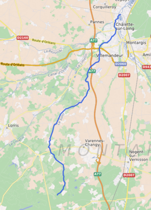
Montargis station
Distance: Approx. 1255 meters
Latitude and longitude: 48.00694444,2.74305556
Montargis is a railway station in Montargis, Centre-Val de Loire, France. The station is located on the Moret-Lyon railway. The station is served by Intercités (long distance) services operated by SNCF between Paris and Nevers, and by Transilien line R (from Paris-Gare de Lyon).
Canton of Châlette-sur-Loing
Distance: Approx. 1604 meters
Latitude and longitude: 48.01,2.73
The canton of Châlette-sur-Loing is an administrative division of the Loiret department, central France. Its borders were modified at the French canton reorganisation which came into effect in March 2015. Its seat is in Châlette-sur-Loing.
Canton of Montargis
Distance: Approx. 664 meters
Latitude and longitude: 48,2.73
The canton of Montargis is an administrative division of the Loiret department, central France. Its borders were modified at the French canton reorganisation which came into effect in March 2015. Its seat is in Montargis.
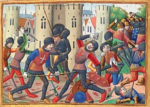
Siege of Montargis
1427 siege during the Hundred Years' War
Distance: Approx. 323 meters
Latitude and longitude: 47.9978,2.7333
The siege of Montargis (15 July – 5 September 1427) took place during the Hundred Years War. A French relief army under Jean de Dunois routed an English force led by the Earl of Warwick.
Communauté d'agglomération Montargoise et Rives du Loing
Communauté d'agglomération in Centre-Val de Loire, France
Distance: Approx. 2106 meters
Latitude and longitude: 47.98333333,2.71666667
Communauté d'agglomération Montargoise et Rives du Loing is the communauté d'agglomération, an intercommunal structure, centred on the town of Montargis. It is located in the Loiret department, in the Centre-Val de Loire region, central France. Created in 2002, its seat is in Montargis.
Weather in this IP's area
broken clouds
12 Celsius
12 Celsius
12 Celsius
12 Celsius
1016 hPa
95 %
1016 hPa
1006 hPa
10000 meters
3.33 m/s
8.24 m/s
208 degree
60 %
08:14:26
18:53:09