Country:
 Czech Republic
Region:
City:
Latitude and Longitude:
Time Zone:
Postal Code:
IP information under different IP Channel
ip-api
Country
Region
City
ASN
Time Zone
ISP
Blacklist
Proxy
Latitude
Longitude
Postal
Route
IPinfo
Country
Region
City
ASN
Time Zone
ISP
Blacklist
Proxy
Latitude
Longitude
Postal
Route
MaxMind
Country
Region
City
ASN
Time Zone
ISP
Blacklist
Proxy
Latitude
Longitude
Postal
Route
Luminati
Country
CZASN
Time Zone
Europe/Prague
ISP
Webglobe, s.r.o.
Latitude
Longitude
Postal
db-ip
Country
Region
City
ASN
Time Zone
ISP
Blacklist
Proxy
Latitude
Longitude
Postal
Route
ipdata
Country
Region
City
ASN
Time Zone
ISP
Blacklist
Proxy
Latitude
Longitude
Postal
Route
Popular places and events near this IP address

Radio Free Europe/Radio Liberty
US-funded international media outlet
Distance: Approx. 473 meters
Latitude and longitude: 50.07888889,14.47861111
Radio Free Europe/Radio Liberty (RFE/RL) is an American government-funded international media organization that broadcasts and reports news, information, and analyses to Eastern Europe, Central Asia, the Caucasus, and the Middle East. RFE/RL is a private 501(c)(3) corporation and is supervised by the U.S. Agency for Global Media, an independent government agency overseeing all international broadcasting services that receive American government support. Nicola Careem is the organization's editor-in-chief.
Third Czechoslovak Republic
Republic in Central Europe from 1945 to 1948
Distance: Approx. 696 meters
Latitude and longitude: 50.0833,14.4667
The Third Czechoslovak Republic (Czech: Třetí Československá republika; Slovak: Tretia česko-slovenská republika), officially the Czechoslovak Republic (Czech: Československá republika; Slovak: Československá republika), was a sovereign state from April 1945 to February 1948 following the end of World War II. After the fall of Nazi Germany, the country was reformed and reassigned coterminous borders as its pre-war predecessor state, First Czechoslovak Republic; it likewise restored the predecessor's international recognition. Due to the rise of the Communist Party of Czechoslovakia (KSČ), Czechoslovakia fell within the Soviet sphere of influence, and this circumstance dominated any plans or strategies for post-war reconstruction. Consequently, the political and economic organisation of Czechoslovakia became largely a matter of negotiations between Edvard Beneš and the Communist Party members exiled in Moscow.
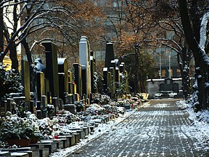
Olšany Cemetery
Graveyard in Prague, Czech Republic
Distance: Approx. 295 meters
Latitude and longitude: 50.080556,14.470556
Olšany Cemeteries (Czech: Olšanské hřbitovy, German: Wolschaner Friedhof) is the largest graveyard in Prague, Czech Republic, once laid out for as many as two million burials. The graveyard is particularly noted for its many remarkable Art Nouveau monuments.
Czech and Slovak Federative Republic
Republic in Central Europe between 1990 and 1992
Distance: Approx. 700 meters
Latitude and longitude: 50.08333333,14.46666667
After the Velvet Revolution in late-1989, Czechoslovakia adopted the official short-lived country name Czech and Slovak Federative Republic (Czech: Česká a Slovenská Federativní Republika, Slovak: Česká a Slovenská Federatívna Republika; ČSFR) during the period from 23 April 1990 until 31 December 1992, after which the country was peacefully dissolved into the Czech Republic and the Slovak Republic.

Czech Socialist Republic
Part of Czechoslovakia between 1969 and 1990
Distance: Approx. 696 meters
Latitude and longitude: 50.0833,14.4667
The Czech Socialist Republic (Czech: Česká socialistická republika, ČSR) was a republic within the Czechoslovak Socialist Republic. The name was used from 1 January 1969 to November 1989, when the previously unitary Czechoslovak state changed into a federation. From 1990 to 1992, the Czech Republic (Czech: Česká republika, ČR) existed as a federal subject within the Czech and Slovak Federative Republic, and later became the independent Czech Republic.

Radio Farda
US-funded Persian language radio
Distance: Approx. 473 meters
Latitude and longitude: 50.07888889,14.47861111
Radio Farda (Persian: راديو فردا, lit. 'Radio Tomorrow') is the Iranian branch of the U.S. government-funded Radio Free Europe/Radio Liberty (RFE/RL) external broadcast service for providing "factual, objective and professional journalism" to its audiences. It broadcasts 24 hours a day in the Persian language from its headquarters in the district Hagibor of Prague, Czech Republic. Radio Farda first aired December 2002.

Flora (Prague Metro)
Prague metro station
Distance: Approx. 778 meters
Latitude and longitude: 50.07763056,14.46123611
Flora is a Prague Metro station on Line A. It is located under the shopping mall Atrium Flora, on the border of the Vinohrady and Žižkov districts near the Olšany Cemetery. The station was opened on 19 December 1980 as part of the extension of the line between Náměstí Míru and Želivského.

Želivského (Prague Metro)
Prague metro station
Distance: Approx. 147 meters
Latitude and longitude: 50.0784,14.4741
Želivského (Czech pronunciation: [ˈʒɛlɪfskɛːɦo]) is a station on Line A of the Prague Metro. The station is located under Vinohradská street next to the Olšany Cemetery. It is named after the Jana Želivského street, which is itself named after Jan Želivský.

New Jewish Cemetery, Prague
Cemetery established 1889
Distance: Approx. 406 meters
Latitude and longitude: 50.08027778,14.47666667
The New Jewish Cemetery (Czech: Nový židovský hřbitov) in Žižkov, Prague, Czech Republic, was established in 1890 to relieve the space problem at the Old Jewish cemetery in Žižkov, where the Žižkov Television Tower now stands. It is about 10 times bigger than the Old Jewish Cemetery in Josefov and provides space for approximately 100,000 graves, therefore having the capacity to serve for a whole century. There is also a specially designated area for urns, though the Jewish tradition does not allow cremation.
Hagibor
Distance: Approx. 591 meters
Latitude and longitude: 50.07888889,14.48027778
Hagibor (Hebrew: הגיבור / ha-gibor, lit. "the hero") is a locality in the district of Strašnice (and partly Žižkov) in Prague, the capital of the Czech Republic. The former local Jewish Czech sport club ŽSK Hagibor was located here, which gave the name to the area.

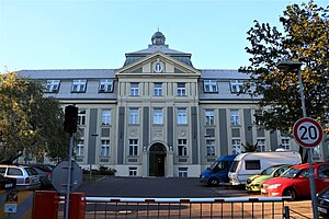
CETIN building
Distance: Approx. 650 meters
Latitude and longitude: 50.08357778,14.46894167
The CETIN building was a building complex in Žižkov, Prague 3 district near Olšany Cemetery. Built in 1979 as the Central Telecommunications Building (Czech: Ústřední telekomunikační budova), it became the headquarters of major operators such as SPT Telecom and O2 Czech Republic after the Velvet Revolution and formation of the Czech Republic. In 2017, the complex was bought by Czech developer Central Group, and until 2022, it served as headquarters of the CETIN telecommunications company.

State Institute for Drug Control
Czech government agency
Distance: Approx. 241 meters
Latitude and longitude: 50.076,14.472925
The State Institute for Drug Control (Czech: Státní ústav pro kontrolu léčiv) is a Czech government agency responsible for regulation of the safe production of pharmaceuticals in the country, clinical evaluation of medicines and for monitoring the advertising and marketing of both medicines and medical devices. Its powers stem from the Act on Public Health Insurance (Act No. 48/1997 Coll.).
Weather in this IP's area
clear sky
13 Celsius
12 Celsius
11 Celsius
14 Celsius
1023 hPa
86 %
1023 hPa
991 hPa
10000 meters
2.57 m/s
360 degree
06:45:49
19:05:11