Country:
 Germany
Region:
City:
Latitude and Longitude:
Time Zone:
Postal Code:
IP information under different IP Channel
ip-api
Country
Region
City
ASN
Time Zone
ISP
Blacklist
Proxy
Latitude
Longitude
Postal
Route
IPinfo
Country
Region
City
ASN
Time Zone
ISP
Blacklist
Proxy
Latitude
Longitude
Postal
Route
MaxMind
Country
Region
City
ASN
Time Zone
ISP
Blacklist
Proxy
Latitude
Longitude
Postal
Route
Luminati
Country
DERegion
be
City
berlin
ASN
Time Zone
Europe/Berlin
ISP
SysEleven GmbH
Latitude
Longitude
Postal
db-ip
Country
Region
City
ASN
Time Zone
ISP
Blacklist
Proxy
Latitude
Longitude
Postal
Route
ipdata
Country
Region
City
ASN
Time Zone
ISP
Blacklist
Proxy
Latitude
Longitude
Postal
Route
Popular places and events near this IP address

West Berlin discotheque bombing
1986 attack in West Germany
Distance: Approx. 323 meters
Latitude and longitude: 52.47305556,13.33666667
On 5 April 1986, three people were killed and 229 injured when La Belle discothèque was bombed in the Friedenau locality (then part of Schöneberg, and since 2001 part of the merged district of Tempelhof-Schöneberg) of West Berlin. The entertainment venue was commonly frequented by United States soldiers; two of the dead and 79 of the injured were Americans. Libya was accused by the US government of sponsoring the bombing, before US president Ronald Reagan ordered retaliatory strikes on Tripoli and Benghazi in Libya ten days later.

Friedenau
Quarter of Berlin in Germany
Distance: Approx. 514 meters
Latitude and longitude: 52.47222222,13.32972222
Friedenau (German: [ˌfriːdə'naʊ̯] ) is a locality (Ortsteil) within the borough (Bezirk) of Tempelhof-Schöneberg in Berlin, Germany. Relatively small by area, its population density is the highest in the city.
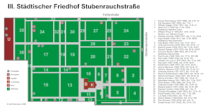
III. Städtischer Friedhof Stubenrauchstraße
Cemetery in Berlin, Germany
Distance: Approx. 812 meters
Latitude and longitude: 52.47638889,13.32277778
Städtischer Friedhof III is a cemetery in the Friedenau district of the borough of Tempelhof-Schöneberg in Berlin, Germany. Buried here are Ferruccio Busoni (1866–1924), Marlene Dietrich (1901–1992) and Helmut Newton (1920–2004).

Rundfunk im amerikanischen Sektor
Radio and television station in the American Sector of Berlin during the Cold War
Distance: Approx. 596 meters
Latitude and longitude: 52.48083333,13.33722222
RIAS (German: Rundfunk im amerikanischen Sektor; English: Radio in the American Sector) was a radio and television station in the American Sector of Berlin during the Cold War. It was founded by the US occupational authorities after World War II in 1946 to provide the German population in and around Berlin with news and political reporting.

Rathaus Schöneberg (Berlin U-Bahn)
Station of the Berlin U-Bahn
Distance: Approx. 955 meters
Latitude and longitude: 52.48305556,13.34194444
Rathaus Schöneberg (Schöneberg Town Hall) is a station on the U4 line of the Berlin underground train network. Designed by architect Johann Emil Schaudt, who also built the Bismarck Monument in Hamburg, the station was first opened in 1910 as Stadtpark (City Park). From 1940 to 1951 it was closed due to damage sustained during the Second World War.

Berlin Innsbrucker Platz station
Railway station in Schöneberg, Berlin, Germany
Distance: Approx. 702 meters
Latitude and longitude: 52.47861111,13.34388889
Berlin Innsbrucker Platz is a railway station in the Schöneberg district of Berlin and located on the square of the same name. It is served by the Ringbahn lines S41, S42 and S46 of the Berlin S-Bahn. It is also the terminus of the U-Bahn line U4.

Deutschlandfunk Kultur
German radio station
Distance: Approx. 596 meters
Latitude and longitude: 52.48083333,13.33722222
Deutschlandfunk Kultur (German: [ˈdɔʏtʃlantˌfʊŋk kʊlˈtuːɐ̯] ; abbreviated to DLF Kultur or DKultur) is a culture-oriented radio station and part of Deutschlandradio, a set of three national radio stations in Germany. Initially named DeutschlandRadio Berlin, the station was renamed Deutschlandradio Kultur on 1 April 2005. The present name was adopted on 1 May 2017.

Berlin Bundesplatz station
Railway station in Berlin, Germany
Distance: Approx. 459 meters
Latitude and longitude: 52.4775,13.32861111
Berlin Bundesplatz is a railway station in the Wilmersdorf district of Berlin. It is served by the S-Bahn lines S41, S42 and S46 and the U-Bahn line U9. The underground station opened in 1971 and was built by R.G. Rümmler.

Friedrich-Wilhelm-Platz (Berlin U-Bahn)
Station of the Berlin U-Bahn
Distance: Approx. 588 meters
Latitude and longitude: 52.47194444,13.32861111
Friedrich-Wilhelm-Platz is a Berlin U-Bahn station located on the U9. It opened for service in 1971. The station was built adjacent to "Zum Guten Hirten" church (1893) on Friedrich-Wilhelm-Platz, which was named after Friedrich Wilhelm of Prussia, who became emperor under the name Friedrich III, and died after only 99 days' reign.

Berlin-Friedenau station
Railway station in Tempelhof-Schöneberg, Germany
Distance: Approx. 765 meters
Latitude and longitude: 52.47,13.341
Berlin-Friedenau is a railway station in Berlin, Germany. Though it is named after the nearby Friedenau locality, the station officially is located in the southern area of the Schöneberg district. It was opened in 1891 with the Wannseebahn rapid transit railway.
Berlin School of Economics and Law
Distance: Approx. 1086 meters
Latitude and longitude: 52.48527778,13.33777778
The Berlin School of Economics and Law (German: Hochschule für Wirtschaft und Recht), abbreviated as BSEL, is a public institution of higher education and research founded on 1 April 2009 through the merger of the Berlin School of Economics (BSE) and the FHVR Berlin. The BSEL portfolio provides a wide range of Bachelor's, Master's and doctoral programmes in fields such as business, administration for the public and private sector, public security, law, or engineering. BSEL has an international approach with close working relationships to over 150 partner universities all over the world.

Bundesautobahn 103
Federal motorway in Germany
Distance: Approx. 1132 meters
Latitude and longitude: 52.46555556,13.33583333
Bundesautobahn 103 (translates from German as Federal Motorway 103, short form Autobahn 103, abbreviated as BAB 103 or A 103) is a short urban Autobahn in Western Berlin, Germany connecting to the A 100. Before reunification, it was called the A 13.
Weather in this IP's area
clear sky
21 Celsius
21 Celsius
20 Celsius
22 Celsius
1001 hPa
70 %
1001 hPa
996 hPa
10000 meters
4.02 m/s
6.71 m/s
180 degree
07:20:05
18:27:53