Country:
Region:
City:
Latitude and Longitude:
Time Zone:
Postal Code:
IP information under different IP Channel
ip-api
Country
Region
City
ASN
Time Zone
ISP
Blacklist
Proxy
Latitude
Longitude
Postal
Route
Luminati
Country
City
pristina
ASN
Time Zone
Europe/Belgrade
ISP
Artmotion Sh.p.k.
Latitude
Longitude
Postal
IPinfo
Country
Region
City
ASN
Time Zone
ISP
Blacklist
Proxy
Latitude
Longitude
Postal
Route
db-ip
Country
Region
City
ASN
Time Zone
ISP
Blacklist
Proxy
Latitude
Longitude
Postal
Route
ipdata
Country
Region
City
ASN
Time Zone
ISP
Blacklist
Proxy
Latitude
Longitude
Postal
Route
Popular places and events near this IP address

Murad I
3rd Sultan of the Ottoman Empire from 1362 to 1389
Distance: Approx. 3238 meters
Latitude and longitude: 42.70194444,21.10416667
Murad I (Ottoman Turkish: مراد اول; Turkish: I. Murad, Murad-ı Hüdavendigâr (nicknamed Hüdavendigâr, from Persian: خداوندگار, romanized: Khodāvandgār, lit. 'the devotee of God' – meaning "sovereign" in this context); 29 June 1326 – 15 June 1389) was the sultan of the Ottoman Empire from 1362 to 1389. He was the son of Orhan Gazi and Nilüfer Hatun. Murad I came into the throne after his elder brother Süleyman Pasha's death.

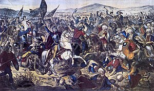
Battle of Kosovo
1389 battle between a Moravian Serbia–led coalition and the Ottoman Empire
Distance: Approx. 3612 meters
Latitude and longitude: 42.7175,21.085
The Battle of Kosovo took place on 15 June 1389 between an army led by the Serbian Prince Lazar Hrebeljanović and an invading army of the Ottoman Empire under the command of Sultan Murad Hüdavendigâr. The battle was fought on the Kosovo field in the territory ruled by Serbian nobleman Vuk Branković, in what is today Kosovo, about 5 kilometers (3.1 mi) northwest of the modern city of Pristina. The army under Prince Lazar consisted mostly of his own troops, a contingent led by Branković, and a contingent sent from Bosnia by King Tvrtko I, commanded by Vlatko Vuković.
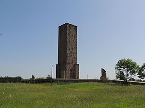
Gazimestan
Memorial site to the Battle of Kosovo (1389)
Distance: Approx. 4381 meters
Latitude and longitude: 42.69055556,21.12361111
Gazimestan (Serbian Cyrillic: Газиместан, Serbian pronunciation: [ɡaziměstaːn], Albanian: Gazimestani) is the name of a memorial site and monument commemorating the Battle of Kosovo (1389), situated about 6–7 kilometres southeast of the actual battlefield, known as the Kosovo field. Gazimestan is accessible from the Pristina–Mitrovica highway, on a 50-metre-high hill above the plain, ca. 5 km northwest of Pristina.
Tomb of Murad I
Distance: Approx. 3238 meters
Latitude and longitude: 42.70194444,21.10416667
The Tomb of Murad I (Albanian: Tyrbja e Sulltan Muratit; Turkish: Sultan I. Murad Türbesi, also known as Meşhed-i Hüdâvendigâr) is a mausoleum (türbe) dedicated to the Ottoman Sultan Murad I located in the Prishtina District, Kosovo. Murad I (nicknamed Hüdavendigâr, meaning the "God-liked one" or the "sovereign" in this context) was killed in the Battle of Kosovo in 1389. The monument was built in the 14th century by Murad I's son Bayezid I, becoming the first example of Ottoman architecture in the Kosovo territory.
Gazimestan speech
June 1989 Slobodan Milošević speech
Distance: Approx. 4359 meters
Latitude and longitude: 42.69055556,21.12333333
The Gazimestan speech (Serbo-Croatian: Govor na Gazimestanu / Говор на Газиместану) was given on 28 June 1989 by Slobodan Milošević, then president of Serbia, at the Gazimestan monument on the Kosovo field. It was the centrepiece of a day-long event to mark the 600th anniversary of the Battle of Kosovo, which was fought at the site in 1389. The speech was delivered to a crowd of an estimated million or more attendees, and came against a backdrop of protracted ethnic tension between ethnic Serbs and Albanians in Kosovo and increasing political tensions between SR Serbia and the other constituent republics of the then SFR Yugoslavia caused by the anti-bureaucratic revolution.

Battle of Belaćevac Mine
Battle of the Kosovo War
Distance: Approx. 702 meters
Latitude and longitude: 42.69,21.07777778
The Battle of Belaćevac Mine was a week-long clash between the Yugoslav Army (VJ), Serbian police (MUP) and the Kosovo Liberation Army (KLA) in June 1998, during the Kosovo War. It was fought over the Belaćevac coal mine, which powered two generating stations that supplied electricity to most of Kosovo. The KLA seized the mine on 22 June, taking nine Serb mineworkers hostage, converting the mine into a base of operations and taunting the Yugoslav authorities by sending daylight patrols within sight of the provincial capital, Pristina.

Kosovo A Power Station
Power station in Obiliq, Kosovo
Distance: Approx. 1677 meters
Latitude and longitude: 42.67527778,21.08333333
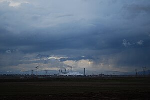
Kosovo A Power Station is a lignite power station with five units at Obiliq, Kosovo. It is the second largest power station in Kosovo with capacity of 650 MW after Kosovo B Power Station. It is described as the worst single-point source of pollution in Europe.

Kosovo B Power Station
Power station in Obiliq, Kosovo
Distance: Approx. 1920 meters
Latitude and longitude: 42.69555556,21.05
Kosovo B Power Station is the largest power station in Obiliq, Kosovo. It is a lignite-fired consisting of 2 units with 340 MW generation capacity, which share a 183 metres (600 ft) tall chimney with 6.8 metres diameter at the top.

Church of the Nativity of the Theotokos, Obiliq
Distance: Approx. 702 meters
Latitude and longitude: 42.69,21.07777778
The Church of the Nativity of the Most Holy Mother of God (Albanian: Kisha e Zonjushës; Serbian: Црква Мала Госпојина / Crkva Mala Gospojina) is a Serbian Orthodox Church in Obiliq, Kosovo. As of 2008, it serves some 2,200 Serbs in the municipality of Obiliq. It is ecclesiastically part of the Eparchy of Raška and Prizren.

Kosovo field
Plain in eastern Kosovo
Distance: Approx. 3612 meters
Latitude and longitude: 42.7175,21.085
Kosovo field (Albanian: Fusha e Kosovës; Serbian: Косово поље, romanized: Kosovo polje, lit. 'Blackbird's Field') is a large karst field, located in the middle part of Kosovo. It is mostly known for being the site of the Battle of Kosovo (1389) between the Balkan Alliance led by Lazar of Serbia and Ottoman armies led by Murad I, and many other battles.

Mazgit
Village in Prishtinë, Kosovo
Distance: Approx. 1696 meters
Latitude and longitude: 42.689011,21.090821
Mazgit (Albanian: Mazgit, Serbian Cyrillic: Мазгит/Mazgit) is a village in the Obiliq municipality, Kosovo.

Sunny Hill Festival
Annual music festival in Kosovo
Distance: Approx. 5075 meters
Latitude and longitude: 42.70785312,21.12538523
The Sunny Hill Festival is an annual international music festival in Pristina, Kosovo, organised by English and Albanian singer Dua Lipa and her father Dukagjin Lipa. It has established itself as the largest music festival in Kosovo.
Weather in this IP's area
broken clouds
3 Celsius
-2 Celsius
2 Celsius
3 Celsius
1026 hPa
77 %
1026 hPa
961 hPa
10000 meters
6.69 m/s
40 degree
75 %
06:28:58
16:12:22

