Country:
Region:
City:
Latitude and Longitude:
Time Zone:
Postal Code:
IP information under different IP Channel
ip-api
Country
Region
City
ASN
Time Zone
ISP
Blacklist
Proxy
Latitude
Longitude
Postal
Route
Luminati
Country
City
pristina
ASN
Time Zone
Europe/Belgrade
ISP
Artmotion Sh.p.k.
Latitude
Longitude
Postal
IPinfo
Country
Region
City
ASN
Time Zone
ISP
Blacklist
Proxy
Latitude
Longitude
Postal
Route
db-ip
Country
Region
City
ASN
Time Zone
ISP
Blacklist
Proxy
Latitude
Longitude
Postal
Route
ipdata
Country
Region
City
ASN
Time Zone
ISP
Blacklist
Proxy
Latitude
Longitude
Postal
Route
Popular places and events near this IP address

Mitrovica, Kosovo
City in Kosovo
Distance: Approx. 5 meters
Latitude and longitude: 42.88333333,20.86666667
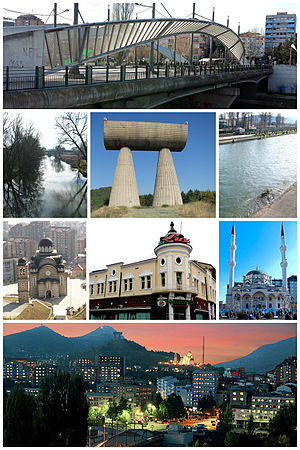
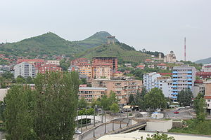
Mitrovica (Albanian indefinite form: Mitrovicë; Serbian Cyrillic: Косовска Митровица), also referred to as South Mitrovica (Albanian: Mitrovicë e Jugut), is a city in northern Kosovo and administrative center of the District of Mitrovica. In 2013, the city was split into two municipalities, South Mitrovica and North Mitrovica. Settled 10 km (6.2 mi) from Ujmani/Gazivoda Lake, on the confluence of the rivers Ibër, Sitnicë, Lushta, and Trepça, the city is surrounded by the mountains of Kopaonik, Rogozna, Mokna, and Çyçavica.

New Bridge, Mitrovica
Bridge across the Ibar river in Mitrovica, Kosovo
Distance: Approx. 933 meters
Latitude and longitude: 42.89166667,20.86611111
The New Bridge (also known as Mitrovica Bridge, Ibar River Bridge, Ibar Bridge or by its unofficial name Austerlitz Bridge) is a steel truss bridge crossing the Ibar river in Mitrovica, Kosovo, connecting South Mitrovica and North Mitrovica. The New Bridge has become an iconic symbol of Kosovo's division, as it separates around 80,000 Kosovo Albanians in the south from around 50 000 Serbs and other nationalities living in the north. It was used as a military checkpoint and provides a de facto boundary and buffer zone between the mainly ethnic Serbian populated North Kosovo and the rest of Kosovo which has an ethnic Albanian majority.

Adem Jashari Olympic Stadium
Multi-purpose stadium in Mitrovica, Kosovo
Distance: Approx. 1288 meters
Latitude and longitude: 42.882101,20.850997
The Adem Jashari Olympic Stadium (Albanian: Stadiumi Olimpik Adem Jashari) is a multi-purpose stadium in Mitrovica, Kosovo, which is used mostly for football matches and has been the home ground of the Kosovan football club KF Trepça since 1999. The stadium has a capacity of around 18,500 after renovation is completed. This stadium, built in 1938, was known as Trepça/Trepča Stadium until 1999.
North Mitrovica
Town and municipality in Mitrovica, Kosovo
Distance: Approx. 1237 meters
Latitude and longitude: 42.894406,20.866095
North Mitrovica or North Kosovska Mitrovica, is a town and municipality located in Mitrovica District in Kosovo. As of 2015, it has a population of 29,460 inhabitants. It covers an area of 11 km2 (4 sq mi).

District of Mitrovica
District of Kosovo
Distance: Approx. 793 meters
Latitude and longitude: 42.89,20.87
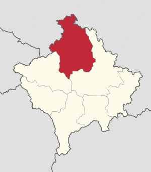
Mitrovica District (Albanian: Rajoni i Mitrovicës; Serbian Cyrillic: Косовскомитровачки округ, Kosovskomitrovački okrug) is one of the seven districts of Kosovo. Its administrative center and the largest city is Mitrovica. The district borders on the District of Peja to the south-west, the District of Pristina to the south and east, and the Serbia to the north and northwest.
Suhodoll i Poshtëm
Village in Mitrovicë, Kosovo
Distance: Approx. 1362 meters
Latitude and longitude: 42.88333333,20.85
Suhodoll i Poshtëm (Albanian: Tejibri i Poshtëm) or Donji Suvi Do (in Serbian) is a village in the municipality of North Mitrovica in the District of Mitrovica, Kosovo. According to the 2011 census, it has 789 inhabitants, of whom 787 are Albanians. It is a village of the scattered type, at 520 to 540 metres (1,710 to 1,770 ft) above sea level, on the left valley side of the Ibar river, southeast of the foot of Rogozna (1,479 m [4,852 ft]).
Suhodolli i Epërm
Village in Mitrovicë, Kosovo
Distance: Approx. 1544 meters
Latitude and longitude: 42.88666667,20.84833333
Suhodoll i Epërm (in Albanian) or Gornji Suvi Do (in Serbian: Горњи Суви До) is a village in the municipality of North Mitrovica in the District of Mitrovica, Kosovo. According to the 2011 census, it has 224 inhabitants, all of whom are Albanians.

Minatori Sports Hall
Distance: Approx. 848 meters
Latitude and longitude: 42.890908,20.867235
Minatori Sports Hall is a multi–use sports hall in Mitrovica, Kosovo which is the home of, the KB Trepça basketball, KH Trepça handball, KV Trepça volleyball and FC Trepça futsal teams.

Riza Lushta Stadium
Distance: Approx. 683 meters
Latitude and longitude: 42.88805556,20.86141667
Riza Lushta Stadium is a multi-use stadium in Mitrovica, Kosovo. It was named after notable Juventus player Riza Lushta, who was from Mitrovica, and is used mostly for football matches and is the home ground of Trepça'89 of the Kosovar Superliga. The stadium has a capacity of 5,000 people.

City Museum of Mitrovica
Museum in Kosovo
Distance: Approx. 793 meters
Latitude and longitude: 42.89,20.87
The City Museum of Mitrovica (Albanian: Muzeu i qytetit të Mitrovicës) is a museum in Mitrovica, Kosovo, established in 1952. It is currently housed in the former Yugoslav Army House located in the city center. The museum holds over 1,000 archaeological artifacts from different historical periods, dating back to the Illyrian civilization, and displays over 800 ethnological handiworks, representing the local diversity.

University of Mitrovica
Distance: Approx. 1350 meters
Latitude and longitude: 42.888812,20.88144
Universiteti i Mitrovicёs "Isa Boletini" is a public university located in the city of Mitrovica, Kosovo.

Mitrovica Lake
Artificial lake in Kosovo
Distance: Approx. 1707 meters
Latitude and longitude: 42.88055556,20.84611111
Mitrovica Lake is an artificial lake located near the city of Mitrovica, Kosovo.
Weather in this IP's area
scattered clouds
4 Celsius
3 Celsius
3 Celsius
4 Celsius
1024 hPa
54 %
1024 hPa
962 hPa
10000 meters
1.44 m/s
1.83 m/s
65 degree
37 %
06:30:18
16:12:41
