Country:
Region:
City:
Latitude and Longitude:
Time Zone:
Postal Code:
IP information under different IP Channel
ip-api
Country
Region
City
ASN
Time Zone
ISP
Blacklist
Proxy
Latitude
Longitude
Postal
Route
Luminati
Country
Region
pac
City
marseille
ASN
Time Zone
Europe/Paris
ISP
Free Pro SAS
Latitude
Longitude
Postal
IPinfo
Country
Region
City
ASN
Time Zone
ISP
Blacklist
Proxy
Latitude
Longitude
Postal
Route
db-ip
Country
Region
City
ASN
Time Zone
ISP
Blacklist
Proxy
Latitude
Longitude
Postal
Route
ipdata
Country
Region
City
ASN
Time Zone
ISP
Blacklist
Proxy
Latitude
Longitude
Postal
Route
Popular places and events near this IP address

Marseille-Saint-Charles station
Main railway and bus station of Marseille, France
Distance: Approx. 1031 meters
Latitude and longitude: 43.30305556,5.38111111
Marseille-Saint-Charles (French: Gare de Marseille-Saint-Charles) is the main railway station and intercity bus station of Marseille, France. It is the southern terminus of the Paris–Marseille railway and the western terminus of the Marseille–Ventimiglia railway. It opened on 8 January 1848, having been built for the Chemins de fer de Paris à Lyon et à la Méditerranée (PLM) on the land of the former Saint Charles Cemetery.

Porte d'Aix
Triumphal arch (national heritage monument of the 19th century) in Marseille, France
Distance: Approx. 965 meters
Latitude and longitude: 43.30179167,5.37476389
Porte d'Aix (also known as the Porte Royale) is a triumphal arch in Marseille, in the south of France, marking the old entry point to the city on the road from Aix-en-Provence. The classical design by Michel-Robert Penchaud was inspired by the triumphal arches of the Roman Empire. The Porte d’Aix was initially conceived in 1784 to honour Louis XVI and to commemorate the Peace of Paris (1783) that ended the American Revolutionary War.

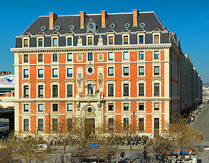
Docks (Marseille)
Distance: Approx. 683 meters
Latitude and longitude: 43.30694444,5.36638889
Les Docks de Marseille is a historical building in the heart of La Joliette, a business district in Marseille, France. The building is home to 220 companies employing some 3,500 people. Various corporate headquarters, regional branches, restaurants, and services are located inside.

La Joliette
Neighborhood in Marseille, France
Distance: Approx. 796 meters
Latitude and longitude: 43.305,5.3669
La Joliette (French pronunciation: [la ʒɔljɛt]; Occitan: La Jolieta) is a neighbourhood of the 2nd arrondissement of Marseille located at the start of the autonomous port of Marseille.

CMA CGM Tower
Skyscraper in Marseille, France
Distance: Approx. 798 meters
Latitude and longitude: 43.315041,5.365841
The CMA CGM Tower is a 147-metre (482 ft) tall skyscraper in Euroméditerranée, the central business district of Marseille, France. Designed by Zaha Hadid, it is the headquarters for CMA CGM, one of the world's major freight companies, hosting 2,200 employees in the office previously spread over seven sites. Zaha Hadid was selected to design the building in November 2004, and it became her first tower.

Euroméditerranée
Urban project in Marseille, France
Distance: Approx. 853 meters
Latitude and longitude: 43.315039,5.364972
Euroméditerranée (French pronunciation: [øʁɔmeditɛʁane]) is an urban renewal project underway in Marseille to create a ecodistrict in the neighbourhood of La Joliette. The project was launched in 1995 with the initiative of Mayor Robert Vigouroux and the State. The agreement for the establishment of a public agency of development was signed in 1994, working on an area of 310 hectares.

3rd arrondissement of Marseille
Municipal arrondissement in Provence-Alpes-Côte d'Azur, France
Distance: Approx. 628 meters
Latitude and longitude: 43.3117,5.3809
The 3rd arrondissement of Marseille is one of the 16 arrondissements of Marseille. It is governed locally together with the 2nd arrondissement, with which it forms the 2nd sector of Marseille.
Église Saint-Théodore
Church in Provence-Alpes-Côte d'Azur, France
Distance: Approx. 1148 meters
Latitude and longitude: 43.3003,5.3762
The Église Saint-Théodore is a Roman Catholic church in Marseille, France.
L'Embobineuse
Distance: Approx. 797 meters
Latitude and longitude: 43.31122,5.38312
L'Embobineuse is a music venue in Marseille. L'Embobineuse is a center for artistic events located in an old factory building. The venue combines artist in residence programming and live performances.
École et Collège Saint-Mauront
Private Catholic school in Marseille, France
Distance: Approx. 857 meters
Latitude and longitude: 43.318,5.375
Ecole et Collège Saint-Mauront is a private Catholic primary and junior high school in the 3rd arrondissement, Marseille, France. It is under the jurisdiction of the Diocese of Marseille.

La Marseillaise (skyscraper)
Skyscraper in Marseille, France
Distance: Approx. 604 meters
Latitude and longitude: 43.3132425,5.367003
La Marseillaise is an office skyscraper in the Euroméditerranée, Marseille, France. It is part of Les Quais d'Arenc development complex and located near the CMA CGM Tower, the city's tallest building. It has 31 floors with an overall height of 135 m (443 ft).

Arenc affair
Affair in Marseille, France on the police abduction of Mohamed Chérif.
Distance: Approx. 1012 meters
Latitude and longitude: 43.31222222,5.36111111
The Arenc affair began on April 16, 1975 in Marseille, France, when attorney Sixte Ugolini publicly condemned the police's kidnapping of his client, Mohamed Chérif, a Moroccan citizen with legal status. Shortly thereafter, the general public discovered a dormant warehouse located in the port of Arenc that had been covertly used by the prefecture for more than a decade to detain non-nationals (primarily Algerians) awaiting deportation, outside of any established legal framework. The affair foreshadowed the establishment of administrative detention centers, which were brought into law in October 1981.
Weather in this IP's area
clear sky
21 Celsius
21 Celsius
20 Celsius
22 Celsius
1024 hPa
72 %
1024 hPa
1021 hPa
10000 meters
1.54 m/s
270 degree
07:16:28
17:27:36
