37.26.148.163 - IP Lookup: Free IP Address Lookup, Postal Code Lookup, IP Location Lookup, IP ASN, Public IP
Country:
 Israel
Region:
City:
Location:
Time Zone:
Postal Code:
ISP:
ASN:
language:
User-Agent:
Proxy IP:
Blacklist:
IP information under different IP Channel
ip-api
Country
Region
City
ASN
Time Zone
ISP
Blacklist
Proxy
Latitude
Longitude
Postal
Route
db-ip
Country
Region
City
ASN
Time Zone
ISP
Blacklist
Proxy
Latitude
Longitude
Postal
Route
IPinfo
Country
Region
City
ASN
Time Zone
ISP
Blacklist
Proxy
Latitude
Longitude
Postal
Route
IP2Location
37.26.148.163Country
ilRegion
hadarom
City
ashqelon
Time Zone
Asia/Jerusalem
ISP
Language
User-Agent
Latitude
Longitude
Postal
ipdata
Country
Region
City
ASN
Time Zone
ISP
Blacklist
Proxy
Latitude
Longitude
Postal
Route
Popular places and events near this IP address
Ashkelon
City in Israel
Distance: Approx. 438 meters
Latitude and longitude: 31.66666667,34.56666667
Ashkelon or Ashqelon ( ASH-kə-lon; Hebrew: אַשְׁקְלוֹן, romanized: ʾAšqəlōn, IPA: [ʔaʃkeˈlon] ; Arabic: عَسْقَلَان, romanized: ʿAsqalān) is a coastal city in the Southern District of Israel on the Mediterranean coast, 50 kilometres (30 mi) south of Tel Aviv, and 13 kilometres (8 mi) north of the border with the Gaza Strip. The modern city is named after the ancient seaport of Ascalon, which was destroyed in 1270 and whose remains are on the southwestern edge of the modern metropolis. The Israeli city, first known as Migdal, was founded in 1949 approximately 4 km inland from ancient Ascalon at the Palestinian town of al-Majdal (Arabic: الْمِجْدَل, romanized: al-Mijdal; Hebrew: אֵל־מִגְ׳דַּל, romanized: ʾĒl-Mīǧdal).

Battle of Ascalon
1099 final battle of the First Crusade
Distance: Approx. 1160 meters
Latitude and longitude: 31.67055556,34.55805556
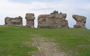
The Battle of Ascalon took place on 12 August 1099 shortly after the capture of Jerusalem, and is often considered the last action of the First Crusade. The crusader army led by Godfrey of Bouillon defeated and drove off a Fatimid army. The Crusaders completed their primary objective of capturing Jerusalem on 15 July 1099.

Siege of Ascalon
1153 battle of the Crusades
Distance: Approx. 2103 meters
Latitude and longitude: 31.66713333,34.54813889
The siege of Ascalon took place from 25 January to 22 August 1153, in the time period between the Second and Third Crusades, and resulted in the capture of the Fatimid Egyptian fortress by the Kingdom of Jerusalem. Ascalon was an important castle that was used by the Fatimids to launch raids into the Crusader kingdom's territory, and by 1153 it was the last coastal city in Palestine that was not controlled by the Crusaders. The siege lasted for several months without much progress, despite the usage of siege engines and catapults by the Crusader army.

Ashkelon Academic College
Distance: Approx. 139 meters
Latitude and longitude: 31.66905278,34.57165833
Ashkelon Academic College (Hebrew: המכללה האקדמית אשקלון, HaMiklala HaAkademit Ashkelon) is a public college in Ashkelon, Israel. The college has two faculties, the School of Economics and Social Work, for management, logistics, banking, and accounting, in which undergraduate and graduate studies take place, as well as the School of Health Sciences, for undergraduate studies in nutrition, nursing, and public health. The college provides programs in undergraduate studies in the fields of politics and government, computer science, sociology and anthropology, psychology, criminology, Land of Israel studies, tourism and multidisciplinary studies in the social sciences.

Al-Jura
Place in Gaza, Mandatory Palestine
Distance: Approx. 1514 meters
Latitude and longitude: 31.66583333,34.55472222
This page is subject to the extended confirmed restriction related to the Arab-Israeli conflict. Al-Jura (Arabic: الجورة) was a Palestinian village that was depopulated during the 1948 Arab-Israeli war, located immediately adjacent to the towns of Ashkelon and the ruins of ancient Ascalon. In 1945, the village had a population of approximately 2,420 mostly Muslim inhabitants.

Barzilai Medical Center
Hospital in Ashkelon, Israel
Distance: Approx. 1285 meters
Latitude and longitude: 31.6619,34.5597
Barzilai Medical Center (Hebrew: מרכז רפואי ברזילי, Merkaz Refu'i Barzilai; Arabic: مركز برزيلاي الطبي) is a 600-bed district general hospital in Ashkelon, Israel opened in 1961. The hospital serves a population of 500,000, including a large number of Ethiopian and Russian immigrants, and has more than 100,000 admissions annually. The grounds contain the site of the former Shrine of Husayn's Head, a Shia pilgrimage site before its destruction by the Israeli Defense Forces under Moshe Dayan in 1950.
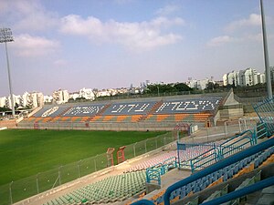
Sala Stadium
Distance: Approx. 394 meters
Latitude and longitude: 31.66571,34.569479
The Sala Stadium (Hebrew: אצטדיון סלה) is a sports stadium in Ashkelon, Israel. The stadium has a 5,250 capacity, and is the home ground of Maccabi Ashkelon. On 29 December 2008, shortly before a training session, the stadium was hit by a Grad rocket fired from the Gaza Strip.

Ashkelon Sports Arena
Indoor sporting arena located in Ashkelon, Israel
Distance: Approx. 820 meters
Latitude and longitude: 31.66216667,34.57278333
The Ashkelon Sport Arena (Hebrew: היכל הספורט העירוני אשקלון) is an indoor sporting arena located in Ashkelon, Israel. The arena opened in 1999 and is home to the Elitzur Eito Ashkelon Basketball Club. The arena has a capacity of 3,000 permanent seats.

Ashkelon Marina Breakwater Light
Lighthouse
Distance: Approx. 2230 meters
Latitude and longitude: 31.68525833,34.55612222
Ashkelon Marina Breakwater Light is a lighthouse in Ashkelon, Israel. It is located at the end of the main breakwater of the Ashkelon Marina. The site is accessible by walking the pier, but the tower is closed to the public.
Nizahon Restaurant
Former Romanian restaurant in Israel
Distance: Approx. 1647 meters
Latitude and longitude: 31.66414,34.58653
Nizahon Restaurant (מסעדת הניצחון) was a Romanian grill in Ashkelon and one of Israel's oldest restaurants. The restaurant did not have kashrut certification and was open on Shabbat.
Ashkelon Subdistrict
Subdistrict in Southern, Israel
Distance: Approx. 522 meters
Latitude and longitude: 31.6658,34.5664
The Ashkelon Subdistrict is the northern of the two sub-districts in Israel's Southern District. Its population is more than half a million. It is an important region for manufacturing including electricity production and water desalination, agriculture, transportation, tourism, and trade.

Shrine of Husayn's Head
Former Fatimid-era Shi'a shrine in Palestine
Distance: Approx. 1416 meters
Latitude and longitude: 31.6605,34.5593
The Shrine of Husayn's Head (Arabic: مشْهد ٱلحُسَين, romanized: Mašhad al-Ḥusayn, lit. 'Mausoleum of Husayn') was a shrine built by the Fatimids on a hilltop adjacent to Ascalon that was reputed to have held the head of Husayn ibn Ali between c. 906 CE and 1153 CE. It was described as the most magnificent building in the ancient city, and developed into the most important and holiest Shi'a site in Palestine. In modern times, it became associated with the Palestinian town of Al-Jura, which sat alongside the ruined citadel of Ascalon.
Weather in this IP's area
light rain
14 Celsius
13 Celsius
14 Celsius
14 Celsius
1021 hPa
66 %
1021 hPa
1018 hPa
10000 meters
7.08 m/s
8.75 m/s
289 degree
25 %