Country:
 Israel
Region:
City:
Latitude and Longitude:
Time Zone:
Postal Code:
IP information under different IP Channel
ip-api
Country
Region
City
ASN
Time Zone
ISP
Blacklist
Proxy
Latitude
Longitude
Postal
Route
IPinfo
Country
Region
City
ASN
Time Zone
ISP
Blacklist
Proxy
Latitude
Longitude
Postal
Route
MaxMind
Country
Region
City
ASN
Time Zone
ISP
Blacklist
Proxy
Latitude
Longitude
Postal
Route
Luminati
Country
ILASN
Time Zone
Asia/Jerusalem
ISP
Cellcom Fixed Line Communication L.P
Latitude
Longitude
Postal
db-ip
Country
Region
City
ASN
Time Zone
ISP
Blacklist
Proxy
Latitude
Longitude
Postal
Route
ipdata
Country
Region
City
ASN
Time Zone
ISP
Blacklist
Proxy
Latitude
Longitude
Postal
Route
Popular places and events near this IP address

Sarona (colony)
Neighborhood in Tel Aviv, Israel
Distance: Approx. 566 meters
Latitude and longitude: 32.0725,34.78861111
Sarona is a neighborhood of Tel Aviv, Israel which started as a German Templer colony in Palestine in 1871. It was one of the earliest modern villages established by Europeans in Ottoman Palestine. In July 1941, the British Mandate authorities deported 188 residents of Sarona, who were considered ardent Nazi sympathizers.

Azrieli Center
Skyscraper complex in Tel Aviv, Israel
Distance: Approx. 528 meters
Latitude and longitude: 32.07444444,34.79166667
Azrieli Center (Hebrew: מֶרְכָּז עַזְרִיאֵלִי; Merkaz Azrieli) is a complex of three skyscrapers in Tel Aviv. At the base of the complex lies a large shopping mall. The complex was designed by Israeli-American architect Eli Attia.
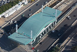
Tel Aviv–HaShalom railway station
Railway station in Tel Aviv, Israel
Distance: Approx. 366 meters
Latitude and longitude: 32.07333333,34.79319444
Tel Aviv–HaShalom railway station (Hebrew: תַּחֲנַת תֵּל אָבִיב – הַשָּלוֹם) is a major railway station on the Ayalon Railway in central Tel Aviv, Israel, serving most lines of Israel Railways. It is located in the median of the Ayalon Highway at the HaShalom interchange, near the city's main commercial area and HaKirya IDF base. In 2019, over 15 million passengers used the station, making it the busiest in the country.

HaYovel Tower
Offices in Tel Aviv, Israel
Distance: Approx. 544 meters
Latitude and longitude: 32.07294722,34.78921111
HaYovel Tower (Hebrew: מגדל היובל, lit. 'Jubilee Tower') also known as Kiryat HaMemshala Tower (Hebrew: מגדל קריית הממשלה, lit. 'Government Complex Tower') is a skyscraper in Tel Aviv, Israel. At 158 m (42 floors), it is the 20th tallest building in Israel. Construction was completed in 2005 on land previously belonging to the IDF HaKirya base.

Tel Aviv Towers
Residential in Tel Aviv, Israel מגדלי תל אביב
Distance: Approx. 599 meters
Latitude and longitude: 32.07416667,34.79805556
The Tel Aviv Towers are a complex of four skyscrapers in the city of Tel Aviv, Israel. All four buildings in the complex are complete. Towers 1 and 2 are each 107.75 meters in height, have 34 floors, and were built between 1998 and 2000.

Electra Tower
Office in Tel Aviv, Israel
Distance: Approx. 32 meters
Latitude and longitude: 32.07027778,34.79416667
The Electra Tower, previously Amkor Tower or Elco Tower, is an office skyscraper in Tel Aviv, Israel, located on Yigal Allon Street. At 165 meters, it is one of the tallest buildings in the city. Originally it was planned to be 235 meters in height with 65 floors, which would have made it Tel Aviv's tallest tower and one of the country's tallest buildings upon completion, but the final plan lowered this to a 45-floor skyscraper.

Mercantile Discount Bank
Commercial bank in Israel
Distance: Approx. 539 meters
Latitude and longitude: 32.07295,34.78928056
Mercantile Discount Bank (Hebrew: בנק מרכנתיל דיסקונט בע"מ) is a major commercial bank in Israel and is a subsidiary of Israel Discount Bank. It is the sixth-largest bank in Israel.

Medial Tower
Commercial in Tel Aviv, Israel
Distance: Approx. 658 meters
Latitude and longitude: 32.07055556,34.78694444
Medial Tower (Hebrew: המגדל התיכון, HaMigdal HaTikhon), is a high-rise commercial building in Tel Aviv, Israel. Construction began in 2001, and it was completed in 2004. It is 89.00 metre high.
Dates Ground
Distance: Approx. 483 meters
Latitude and longitude: 32.06705556,34.79025
The Dates Ground (Hebrew: מגרש התמרים), also known as Hapoel Ground (Hebrew: מגרש הפועל) was a football ground in the Montefiore neighborhood of Tel Aviv, Israel. The ground was in use between 1941 and 1949, and was abandoned when the club moved to play in an already built stadium in Jaffa, on which the current Bloomfield Stadium stands.

Azrieli Sarona Tower
Skyscraper in Tel Aviv, Israel
Distance: Approx. 540 meters
Latitude and longitude: 32.07194444,34.78861111
The Azrieli Sarona Tower is a skyscraper in the Sarona neighborhood, Tel Aviv, Israel, on Begin Road. It is 238.5 metres (782 ft) high with 61 floors. It is the tallest building in Israel, followed by Ramat Gan's 235-meter-high Moshe Aviv Tower.

Montefiore, Tel Aviv
Neighborhood in Tel Aviv, Israel
Distance: Approx. 441 meters
Latitude and longitude: 32.06888889,34.78944444
Montefiore (Hebrew: מונטיפיורי) is a neighborhood in the center of Tel Aviv, Israel.

Totzeret HaAretz Towers
Complex of office skyscrapers in Tel Aviv, Israel
Distance: Approx. 354 meters
Latitude and longitude: 32.0729,34.79569
Totzeret HaAretz Towers (Hebrew: מגדלי תוצרת הארץ, Migdalei Totzeret HaAretz), stylized as ToHa, is a partly built complex of three office skyscrapers in Tel Aviv, Israel. The first tower was completed in February 2019, and the second is slated to be inaugurated in 2024.
Weather in this IP's area
clear sky
19 Celsius
19 Celsius
17 Celsius
20 Celsius
1014 hPa
65 %
1014 hPa
1012 hPa
10000 meters
2.06 m/s
150 degree
06:47:12
18:03:58