37.231.50.8 - IP Lookup: Free IP Address Lookup, Postal Code Lookup, IP Location Lookup, IP ASN, Public IP
Country:
Region:
City:
Location:
Time Zone:
Postal Code:
IP information under different IP Channel
ip-api
Country
Region
City
ASN
Time Zone
ISP
Blacklist
Proxy
Latitude
Longitude
Postal
Route
Luminati
Country
Region
ku
City
kuwaitcity
ASN
Time Zone
Asia/Kuwait
ISP
Kuwait Telecommunication Company (Under Association)
Latitude
Longitude
Postal
IPinfo
Country
Region
City
ASN
Time Zone
ISP
Blacklist
Proxy
Latitude
Longitude
Postal
Route
IP2Location
37.231.50.8Country
Region
al jahra'
City
al jahra'
Time Zone
Asia/Kuwait
ISP
Language
User-Agent
Latitude
Longitude
Postal
db-ip
Country
Region
City
ASN
Time Zone
ISP
Blacklist
Proxy
Latitude
Longitude
Postal
Route
ipdata
Country
Region
City
ASN
Time Zone
ISP
Blacklist
Proxy
Latitude
Longitude
Postal
Route
Popular places and events near this IP address

Highway of Death
Road in Iraq
Distance: Approx. 5236 meters
Latitude and longitude: 29.3842,47.6518
The Highway of Death (Arabic: طريق الموت ṭarīq al-mawt) is a six-lane highway between Kuwait and Iraq, officially known as Highway 80. It runs from Kuwait City to the border town of Safwan in Iraq and then on to the Iraqi city of Basra. The road was used by Iraqi armored divisions for the 1990 invasion of Kuwait.

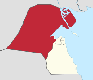
Jahra Governorate
Governorate of Kuwait
Distance: Approx. 59 meters
Latitude and longitude: 29.337,47.658
Jahra Governorate (Arabic: محافظة الجهراء Muḥāfaẓat al-Ǧahrāʾ) is one of the six governorates of Kuwait. It is the largest Governorate in Kuwait accounting for 63 percent of its land area. It includes the town of Al Jahra, most of the northern and western parts of Kuwait, several islands (among them Bubiyan Island).

Mutla Ridge
Most prominent landform in Kuwait
Distance: Approx. 5644 meters
Latitude and longitude: 29.38333333,47.63333333
The Mutla Ridge is the most prominent hill in Kuwait. Located in the Jahra Governorate, the ridge's highest point is 466 feet (142 metres) above sea level. Despite being Kuwait's most prominent mountain, it is not the highest point in the country, which is an unnamed point in far western Kuwait with no topographic prominence.
Kazma
Ancient city in Kuwait
Distance: Approx. 6294 meters
Latitude and longitude: 29.392881,47.671255
Kazma (Arabic: كاظمة) is an area in Kuwait. It is located in Al Jahra Governorate, 40 km (25 mi) north of Kuwait City, the capital of Kuwait. It is an ancient area with a long history, known to Persians and Arabs since the Sassanid, Jahiliyyah and the early Islamic eras.
Al Jahra
Place in Al Jahra Governorate, Kuwait
Distance: Approx. 2808 meters
Latitude and longitude: 29.35,47.68333333
Al Jahra (Arabic: الجهراء) is a city and area located 32 kilometres (20 mi) west of the centre of Kuwait City in Kuwait. Al Jahra is the capital of the Al Jahra Governorate of Kuwait as well as the surrounding Al Jahra District which is agriculturally based. Encyclopædia Britannica recorded the population in 1980 as 67,311.
2009 Kuwait wedding fire
Arson attack in Kuwait
Distance: Approx. 2805 meters
Latitude and longitude: 29.35,47.6833
The 2009 Kuwait wedding fire was an arson attack that occurred during a wedding ceremony in Oyoun, Jahra Governorate, Kuwait on 15 August 2009.
Mubarak Al-Aiar Stadium
Multiuse stadium in Jahra, Kuwait
Distance: Approx. 3746 meters
Latitude and longitude: 29.345,47.69583333
The Al-Shabab Mubarak al-Aiar Stadium is a multi-use stadium in Jahra, Kuwait. It is used mostly for football matches, on club level by Al Jahra of the Kuwaiti Premier League. The stadium has a capacity of 17,000 spectators.

Jahra Hospital
Hospital in Jahra Governorate, Kuwait
Distance: Approx. 2458 meters
Latitude and longitude: 29.338466,47.683507
The Jahra Hospital (Arabic: مستشفى الجهراء) is the main public general hospital in the Jahra Governorate, Kuwait. It was first opened in 1981.

Kuwait Red Fort
Historical palace in Kuwait
Distance: Approx. 2417 meters
Latitude and longitude: 29.348,47.68
The Kuwait Red Fort (Arabic: القصر الأحمر, romanized: al-Qaṣr al-ʾAḥmar) is a historic palace and museum that lies about 32 kilometres west of Kuwait City in Al-Jahra. The fort was the location of the Battle of Jahra in 1920.
Weather in this IP's area
clear sky
14 Celsius
13 Celsius
14 Celsius
14 Celsius
1023 hPa
52 %
1023 hPa
1014 hPa
10000 meters
4.94 m/s
8.65 m/s
294 degree