Country:
 Germany
Region:
City:
Latitude and Longitude:
Time Zone:
Postal Code:
IP information under different IP Channel
ip-api
Country
Region
City
ASN
Time Zone
ISP
Blacklist
Proxy
Latitude
Longitude
Postal
Route
IPinfo
Country
Region
City
ASN
Time Zone
ISP
Blacklist
Proxy
Latitude
Longitude
Postal
Route
MaxMind
Country
Region
City
ASN
Time Zone
ISP
Blacklist
Proxy
Latitude
Longitude
Postal
Route
Luminati
Country
DERegion
bw
City
seebach
ASN
Time Zone
Europe/Berlin
ISP
TelemaxX Telekommunikation GmbH
Latitude
Longitude
Postal
db-ip
Country
Region
City
ASN
Time Zone
ISP
Blacklist
Proxy
Latitude
Longitude
Postal
Route
ipdata
Country
Region
City
ASN
Time Zone
ISP
Blacklist
Proxy
Latitude
Longitude
Postal
Route
Popular places and events near this IP address

Hornisgrinde
Mountain in Germany
Distance: Approx. 3832 meters
Latitude and longitude: 48.60694444,8.2025
The Hornisgrinde, 1,164 m (3,820 ft), is the highest mountain in the Northern Black Forest of Germany. The Hornisgrinde lies in northern Ortenaukreis district.
Kappelrodeck
Municipality in Baden-Württemberg, Germany
Distance: Approx. 4206 meters
Latitude and longitude: 48.59111111,8.1175
Kappelrodeck (Low Alemannic: Kabbl) is a town in Western Baden-Württemberg, Germany and belongs to the district of Ortenau. It is located at the western hillslope of the Black Forest in the valley Achertal. It is about 20 kilometres to the north of Offenburg and about 20 kilometres to the south of Baden-Baden.

All Saints' Abbey (Baden-Württemberg)
Monastery in Baden-Württemberg, Germany
Distance: Approx. 4957 meters
Latitude and longitude: 48.53722222,8.19416667
All Saints' Abbey (German: Kloster Allerheiligen) was a Premonstratensian monastery near Oppenau in the Black Forest in Baden-Württemberg, Germany. It is located at 620 metres above sea level in the upper valley of the Lierbach.
Ottenhöfen im Schwarzwald
Municipality in Baden-Württemberg, Germany
Distance: Approx. 2030 meters
Latitude and longitude: 48.5675,8.15055556
Ottenhöfen im Schwarzwald (Low Alemannic: Oddeheefe) is a town in the district of Ortenau in Baden-Württemberg in Germany.

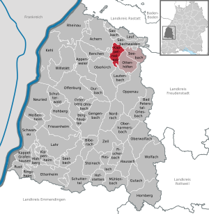
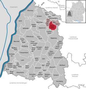
Seebach, Baden-Württemberg
Municipality in Baden-Württemberg, Germany
Distance: Approx. 430 meters
Latitude and longitude: 48.57666667,8.17611111
Seebach is a town in the district of Ortenau in Baden-Württemberg in Germany.

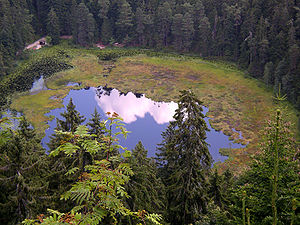
Mummelsee
Small lake in the Black Forest, Germany
Distance: Approx. 3001 meters
Latitude and longitude: 48.59805556,8.20083333
The Mummelsee is a 17-metre-deep lake at the western mountainside of the Hornisgrinde in the Northern Black Forest of Germany. It is very popular with tourists travelling along the Black Forest High Road. According to legends, the lake is inhabited by a Nix and the King of the Mummelsee.

Seekopf (Seebach)
Mountain of the Black Forest
Distance: Approx. 4695 meters
Latitude and longitude: 48.57083,8.23417
The Seekopf is a mountain on the main chain of the Northern Black Forest in Germany between the Upper Rhine Plain and the Murg valley, above Seebach. It is 1,054.2 m above sea level (NHN) and lies on the boundary of the counties of Ortenaukreis and Freudenstadt in the state of Baden-Württemberg. The mountain ridge, the upper area of which is formed of bunter sandstone, belongs to the natural region known as Grindenschwarzwald and Enzhöhen.

Acher Valley Railway
Railway line in Germany
Distance: Approx. 2123 meters
Latitude and longitude: 48.56667,8.14997
The Acher Valley Railway (German: Achertalbahn) is a 10.4 km long branch line from Achern to Ottenhöfen im Schwarzwald in the Black Forest in Germany that branches off the Rhine Valley Railway.
Black Forest National Park
National Park in Baden-Württemberg, Germany
Distance: Approx. 4177 meters
Latitude and longitude: 48.56111111,8.22138889
The Black Forest National Park (German: Nationalpark Schwarzwald) is a national park in the state of Baden-Württemberg in the southwest of Germany. It has an area of 10,062 hectares (100.62 km2; 38.85 sq mi) and is located on the main crest of the Northern Black Forest, mainly between the Black Forest High Road (Schwarzwaldhochstraße) and the valley of the Murg. It comprises two separate areas, roughly 3.5 kilometres apart, around Ruhestein (7,615 ha) and Hoher Ochsenkopf/Plättig (2,447 ha) and is part of the Central/North Black Forest Nature Park (Naturpark Schwarzwald Mitte/Nord).

Ruhestein
Distance: Approx. 4178 meters
Latitude and longitude: 48.56111,8.22139
The Ruhestein is a mountain pass (915 m above NN) between the Murg valley and the Acher valley in the Northern Black Forest. The border between the old Grand Duchy of Baden and the Kingdom of Württemberg ran over the pass, a large sandstone erratic marking the former border. Today it forms the provincial, county and municipal boundary between Baiersbronn (county of Freudenstadt) and Seebach (Ortenaukreis).

Silbergründle Pit
Mine in
Distance: Approx. 286 meters
Latitude and longitude: 48.580034,8.168031
The Silbergründle Pit (German: Grube Silbergründle) near Seebach in the Black Forest in Germany was a lead and silver mine.

Karlsruher Grat
Distance: Approx. 2108 meters
Latitude and longitude: 48.5621,8.184
The Karlsruher Grat is a mountain ridge approximately 400 m long, situated near Ottenhöfen in the Black Forest in Germany. An alpine route with a climbing section passes along it. It is considered the only via ferrata in the Northern Black Forest.
Weather in this IP's area
overcast clouds
11 Celsius
11 Celsius
11 Celsius
12 Celsius
1023 hPa
99 %
1023 hPa
974 hPa
10000 meters
0.45 m/s
0.89 m/s
21 degree
100 %
07:05:52
19:38:29