Country:
 Germany
Region:
City:
Latitude and Longitude:
Time Zone:
Postal Code:
IP information under different IP Channel
ip-api
Country
Region
City
ASN
Time Zone
ISP
Blacklist
Proxy
Latitude
Longitude
Postal
Route
IPinfo
Country
Region
City
ASN
Time Zone
ISP
Blacklist
Proxy
Latitude
Longitude
Postal
Route
MaxMind
Country
Region
City
ASN
Time Zone
ISP
Blacklist
Proxy
Latitude
Longitude
Postal
Route
Luminati
Country
DERegion
he
City
frankfurtammain
ASN
Time Zone
Europe/Berlin
ISP
Tube-Hosting
Latitude
Longitude
Postal
db-ip
Country
Region
City
ASN
Time Zone
ISP
Blacklist
Proxy
Latitude
Longitude
Postal
Route
ipdata
Country
Region
City
ASN
Time Zone
ISP
Blacklist
Proxy
Latitude
Longitude
Postal
Route
Popular places and events near this IP address
Grand Duchy of Frankfurt
State
Distance: Approx. 673 meters
Latitude and longitude: 50.11666667,8.68333333
The Grand Duchy of Frankfurt was a German satellite state of Napoleonic creation. It came into existence in 1810 through the combination of the former territories of the Archbishopric of Mainz along with the Free City of Frankfurt itself.

Confederation of the Rhine
Napoleonic union of German client states
Distance: Approx. 673 meters
Latitude and longitude: 50.11666667,8.68333333
The Confederated States of the Rhine, simply known as the Confederation of the Rhine or Rhine Confederation, was a confederation of German client states established at the behest of Napoleon some months after he defeated Austria and Russia at the Battle of Austerlitz. Its creation brought about the dissolution of the Holy Roman Empire shortly afterward. The Confederation of the Rhine lasted for only seven years, from 1806 to 1813, dissolving after Napoleon's defeat in the War of the Sixth Coalition.

Innenstadt (Frankfurt am Main)
Quarter of Frankfurt am Main in Hesse, Germany
Distance: Approx. 683 meters
Latitude and longitude: 50.12027778,8.68277778
The Innenstadt (inner city) is the central city district of Frankfurt am Main, Germany. It is part of the Ortsbezirk Innenstadt I. Its western part forms part of Frankfurt's central business district, the Bankenviertel. Germany's most expensive shopping streets and real estate are found within the city district.

Nordend (Frankfurt am Main)
Quarter of Frankfurt am Main in Hesse, Germany
Distance: Approx. 463 meters
Latitude and longitude: 50.12305556,8.69222222
Nordend-West and Nordend-Ost are two quarters of Frankfurt am Main, Germany. The division into a western and an eastern part is mostly for administrative purposes, as the Nordend is generally considered an entity.

Frankfurter Engel
Memorial to homosexual victims during Nazi Germany
Distance: Approx. 542 meters
Latitude and longitude: 50.11680556,8.68525
The Frankfurter Engel (German for Frankfurt angel) is a memorial in the city of Frankfurt am Main in southwestern Germany; it is dedicated to homosexual people who were persecuted under Nazi rule, and as well as under Paragraph 175 of the German Criminal Code during the 1950s and 1960s.

Frankfurt Konstablerwache station
Underground railway station in Frankfurt am Main
Distance: Approx. 618 meters
Latitude and longitude: 50.11472222,8.68638889
Frankfurt am Main Konstablerwache station (German: Bahnhof Frankfurt am Main Konstablerwache) is a major train station and metro station at the Konstablerwache square in the city centre of Frankfurt am Main, Germany. With 191,000 passengers per day, Konstablerwache station is the second busiest rapid transit station in Frankfurt after Frankfurt Central Station, and a major hub for commuter transport in the Frankfurt/Rhine-Main region. It is served by eight S-Bahn lines (S1–S6, S8, S9), four U-Bahn lines (U4-U7), two tram lines (12, 18) and two bus lines (30, 36).

Konstablerwache
Town square in Frankfurt, Germany
Distance: Approx. 618 meters
Latitude and longitude: 50.11444444,8.68694444
Konstablerwache is a square in the centre of Frankfurt am Main and part of the city's pedestrian zone. It lies to the east of Hauptwache with both squares linked by the Zeil, the central shopping street of the city.
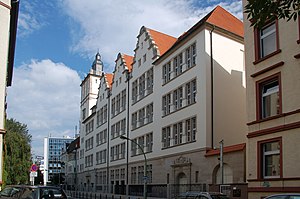
Musterschule
Gymnasium school in Frankfurt, Germany
Distance: Approx. 577 meters
Latitude and longitude: 50.12194444,8.68555556
The Musterschule ("model school") is a gymnasium in Frankfurt, Germany. It was founded on 18 April 1803 by Wilhelm Friedrich Hufnagel as a Realschule and is Frankfurt's second oldest higher school after the Lessing Gymnasium. It received the name Musterschule due to being an experimental and progressive school based on Johann Heinrich Pestalozzi's educational ideas.

Maingau Clinic of the Red Cross
Distance: Approx. 291 meters
Latitude and longitude: 50.1193522,8.6880881
The Maingau Clinic of the Red Cross (German: Klinik Maingau vom Roten Kreuz) is a clinic in Frankfurt, Germany, which is run by the German Red Cross. It is located near the Eschenheimer Anlage park in central Frankfurt, with the address Scheffelstraße 2–14. The clinic traces its history to the 1890 establishment of the Maingau Nursing Society by the Frankfurt branch of the Patriotic Women's Association.
Philanthropin
Jewish elementary school and gymnasium in Frankfurt, Germany
Distance: Approx. 427 meters
Latitude and longitude: 50.1211,8.6872
The Philanthropin (Greek for "place of humanity") is a Jewish elementary school and gymnasium in Frankfurt, Germany. It was founded in 1804 by Mayer Amschel Rothschild.

Uhrtürmchen
Clock tower monument in Frankfurt
Distance: Approx. 428 meters
Latitude and longitude: 50.11576,8.69556
Uhrtürmchen (lit. 'clock turret') is a protected monument in Frankfurt am Main, Germany, located at the corner of Friedberger Anlage near the Zoo. It is one of only two remaining clock towers in the city, the other being located in Bornheim, and is the oldest surviving one, having been first erected in the 19th century. Today the tower serves as a popular tourist attraction, as well as a meeting point for people in the city.

Church of St Peter, Frankfurt
Church in Frankfurt, Hesse, Germany
Distance: Approx. 613 meters
Latitude and longitude: 50.1175,8.6838
The Church of St Peter (German: Peterskirche) is a former evangelical church located in the Innenstadt area of Frankfurt, Germany. It has been known as jugend-kultur-kirche sankt peter since 2007, when it became a youth centre. The church built between 1891 and 1894 on a neo-Renaissance design by Hans Grisebach and Georg Dinklage.It was built on the site of the historic St Peter's Churchyard (German: Peterskirchhof), where most of Frankfurt's dead was buried until 1828.
Weather in this IP's area
few clouds
15 Celsius
15 Celsius
14 Celsius
16 Celsius
987 hPa
95 %
987 hPa
974 hPa
10000 meters
3.09 m/s
70 degree
20 %
07:37:57
18:46:35