37.205.63.161 - IP Lookup: Free IP Address Lookup, Postal Code Lookup, IP Location Lookup, IP ASN, Public IP
Country:
Region:
City:
Location:
Time Zone:
Postal Code:
IP information under different IP Channel
ip-api
Country
Region
City
ASN
Time Zone
ISP
Blacklist
Proxy
Latitude
Longitude
Postal
Route
Luminati
Country
Region
eng
City
lambeth
ASN
Time Zone
Europe/London
ISP
Convergence (group Networks) Limited
Latitude
Longitude
Postal
IPinfo
Country
Region
City
ASN
Time Zone
ISP
Blacklist
Proxy
Latitude
Longitude
Postal
Route
IP2Location
37.205.63.161Country
Region
england
City
gateshead
Time Zone
Europe/London
ISP
Language
User-Agent
Latitude
Longitude
Postal
db-ip
Country
Region
City
ASN
Time Zone
ISP
Blacklist
Proxy
Latitude
Longitude
Postal
Route
ipdata
Country
Region
City
ASN
Time Zone
ISP
Blacklist
Proxy
Latitude
Longitude
Postal
Route
Popular places and events near this IP address

Trinity Square, Gateshead
Shopping quarter in Gateshead, Tyne and Wear, England
Distance: Approx. 74 meters
Latitude and longitude: 54.9627,-1.6022
Trinity Square is a shopping and leisure centre in Gateshead, Tyne and Wear, England. The new centre was constructed on the site of former multi-storey car park and shopping complex going by the same name, which originally opened in 1967. The former Trinity Square was noted for its Brutalist architecture produced by Rodney Gordon when he worked for the Owen Luder Partnership.

Gateshead TMD
Locomotive maintenance yard in the North of England
Distance: Approx. 584 meters
Latitude and longitude: 54.9637,-1.6104
Gateshead TMD was a railway traction maintenance depot situated in Gateshead, England. The depot code was 52A during the steam era and GD later on. It was known, along with the adjacent locomotive works, as Greenesfield or Greensfield, after a Mr.

Gateshead Interchange
Tyne and Wear Metro station in Gateshead
Distance: Approx. 178 meters
Latitude and longitude: 54.9617219,-1.6044065
Gateshead Interchange is a Tyne and Wear Metro station, serving the town of Gateshead in Tyne and Wear, England. It joined the network on 15 November 1981, following the opening of the third phase of the network, between Haymarket and Heworth.

Gateshead College
College in Gateshead, England
Distance: Approx. 562 meters
Latitude and longitude: 54.96668889,-1.59803889
Gateshead College is a further education college in the town of Gateshead, England. It offers further education for 16-18 year olds as well as higher education, apprenticeships, part-time adult learning and training for employers. Established on November 15, 1955 at Durham Road in Low Fell, Gateshead, it was closed in January 2008 for its displacement to the new main site located at the Baltic Quayside in Gateshead.
Tyne Bridge Tower
Distance: Approx. 523 meters
Latitude and longitude: 54.96666667,-1.60361111
The Tyne Bridge Tower was a tower block that stood at the foot of the Tyne Bridge on the Gateshead side of the River Tyne, near the medieval St Mary's Church and the Sage Centre. It was constructed in the 1960s. The 13-floor building was used by the Inland Revenue until June 2005, after which it stood empty until its demolition in March 2011.

The Sage
Planned development in Gateshead, Tyne and Wear
Distance: Approx. 611 meters
Latitude and longitude: 54.9675,-1.6
The Sage is a forthcoming indoor arena and conference centre in Gateshead, United Kingdom due to open in phases between 2025 and 2027. The site is located between The Glasshouse and BALTIC centres on Gateshead Quayside. The arena is being built to replace the nearby 11,000 capacity Utilita Arena Newcastle that was originally opened in 1995.
Amazing Radio
Internet radio station
Distance: Approx. 456 meters
Latitude and longitude: 54.966038,-1.603667
Amazing Radio is an international radio station first broadcast originally on digital radio in the United Kingdom. The station plays new music from a number of music genres including pop, rock, indie, hip hop, electronica and jazz. The station originally broadcast on the Digital One ensemble which replaced the temporary Birdsong test transmission which had been running for a year and a half beforehand.

St Joseph's Church, Gateshead
Church in Tyne and Wear, England
Distance: Approx. 286 meters
Latitude and longitude: 54.96430556,-1.604
St Joseph's Church is a Catholic church in Gateshead, England.
Gateshead railway station
Former railway station in England
Distance: Approx. 546 meters
Latitude and longitude: 54.9659,-1.6071
Gateshead railway station served the town of Gateshead, England between 1844 and 1981. It was situated on the northern and western sides of the triangular junction to the south of the High Level Bridge which connects Gateshead with Newcastle upon Tyne. There were two portions to the station on different routes; at times they were known as Gateshead East and Gateshead West.

Old Town Hall, Gateshead
Municipal building in Gateshead, Tyne and Wear, England
Distance: Approx. 292 meters
Latitude and longitude: 54.9644,-1.6039
The Old Town Hall is a municipal building in West Street, Gateshead, England. It is a Grade II listed building.

Gateshead Civic Centre
Municipal building in Gateshead, Tyne and Wear, England
Distance: Approx. 322 meters
Latitude and longitude: 54.9594,-1.6035
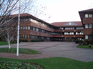
Gateshead Civic Centre is a municipal building in the Regent Street, Gateshead, England.
Oakwellgate railway station
Short-lived railway station in Gateshead, Tyne and Wear
Distance: Approx. 492 meters
Latitude and longitude: 54.9665,-1.601
Oakwellgate railway station served the town of Gateshead, Tyne and Wear, England, from 1839 to 1844 by the Brandling Junction Railway.
Weather in this IP's area
overcast clouds
11 Celsius
10 Celsius
10 Celsius
11 Celsius
1023 hPa
91 %
1023 hPa
1017 hPa
10000 meters
3.26 m/s
8.4 m/s
214 degree
96 %

