37.205.59.20 - IP Lookup: Free IP Address Lookup, Postal Code Lookup, IP Location Lookup, IP ASN, Public IP
Country:
Region:
City:
Location:
Time Zone:
Postal Code:
IP information under different IP Channel
ip-api
Country
Region
City
ASN
Time Zone
ISP
Blacklist
Proxy
Latitude
Longitude
Postal
Route
Luminati
Country
Region
eng
City
lewisham
ASN
Time Zone
Europe/London
ISP
Convergence (group Networks) Limited
Latitude
Longitude
Postal
IPinfo
Country
Region
City
ASN
Time Zone
ISP
Blacklist
Proxy
Latitude
Longitude
Postal
Route
IP2Location
37.205.59.20Country
Region
england
City
bungay
Time Zone
Europe/London
ISP
Language
User-Agent
Latitude
Longitude
Postal
db-ip
Country
Region
City
ASN
Time Zone
ISP
Blacklist
Proxy
Latitude
Longitude
Postal
Route
ipdata
Country
Region
City
ASN
Time Zone
ISP
Blacklist
Proxy
Latitude
Longitude
Postal
Route
Popular places and events near this IP address

Bungay
Town in Suffolk, England
Distance: Approx. 206 meters
Latitude and longitude: 52.456,1.437
Bungay () is a market town, civil parish and electoral ward in the East Suffolk district of Suffolk, England. It lies in the Waveney Valley, 5+1⁄2 miles (9 kilometres) west of Beccles on the edge of The Broads, and at the neck of a meander of the River Waveney. In 2011 it had a population of 5,127.

Ditchingham
Human settlement in England
Distance: Approx. 1433 meters
Latitude and longitude: 52.46676,1.44351
Ditchingham is a village and civil parish in the English county of Norfolk. Ditchingham is located 1.3 miles (2.1 km) north of Bungay and 12 miles (19 km) south-east of Norwich, along the course of the River Waveney.

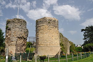
Bungay Castle
Castle in Suffolk
Distance: Approx. 237 meters
Latitude and longitude: 52.456,1.4361
Bungay Castle is a Grade I listed building in the town of Bungay, Suffolk.

Bungay railway station
Disused railway station in England
Distance: Approx. 730 meters
Latitude and longitude: 52.4576,1.4289
Bungay railway station was located on the now disused Waveney Valley Line which ran between Tivetshall and Beccles. The station was closed in 1953 and the buildings eventually demolished to make way for the A143 road. It was one of two stations in Suffolk on the line, which curved across the county boundary then back into Norfolk.

Earsham
Human settlement in England
Distance: Approx. 1449 meters
Latitude and longitude: 52.451825,1.417236
Earsham is a village and civil parish in the English county of Norfolk. Earsham is located 1.1 miles (1.8 km) west of Bungay and 13 miles (21 km) south-east of Norwich. The village is located close to the border between Norfolk and Suffolk, and the River Waveney.

Ditchingham railway station
Former railway station in England
Distance: Approx. 1305 meters
Latitude and longitude: 52.4646,1.4474
Ditchingham was a railway station in Ditchingham, Norfolk on the Waveney Valley Line. Opened on 2 March 1863, it closed to passengers along with the rest of the line in 1953.
Bungay Town F.C.
Association football club in England
Distance: Approx. 961 meters
Latitude and longitude: 52.46190833,1.44489444
Bungay Town Football Club is a football club based in Bungay, Suffolk, England. The club are currently members of the Anglian Combination Premier Division and play at the Maltings Meadow Sports Ground.

Flixton Road Mill, Bungay
Distance: Approx. 714 meters
Latitude and longitude: 52.44861111,1.44305556
Flixton Road Mill is a tower mill at Bungay, Suffolk, England which has been truncated and converted to residential accommodation. The structure is a Grade II listed building.

Bungay High School
School in Suffolk, England
Distance: Approx. 1048 meters
Latitude and longitude: 52.44541,1.44327
Bungay High School is a mixed-sex secondary school with academy status in the town of Bungay in the north of the English county of Suffolk. It caters for pupils aged 11 to 18. The school was founded by Lionel Throckmorton (or Throkmorton) as Bungay Grammar School in 1565 and became Bungay High School in 1974.

Bungay Priory
Priory in Suffolk, England
Distance: Approx. 95 meters
Latitude and longitude: 52.455,1.439
Bungay Priory was a Benedictine nunnery in the town of Bungay in the English county of Suffolk. It was founded c. 1160-1185 by the Countess Gundreda, wife or widow of Hugh Bigod, 1st Earl of Norfolk, upon lands of her maritagium and was confirmed to her and her second husband Roger de Glanville by King Henry II. It was dissolved in about 1536.

Chicken roundabout
Roundabout in Suffolk, United Kingdom
Distance: Approx. 1093 meters
Latitude and longitude: 52.46387,1.44182
The chicken roundabout is a roundabout located on the A143 road, on the Bungay and Ditchingham bypass in Suffolk, United Kingdom. The roundabout was famous for being the habitat for a large group of feral chickens, which were fed and cared for by a local man until their numbers declined and they were relocated in 2010.

St Mary's Church, Bungay
Church in Suffolk, England
Distance: Approx. 146 meters
Latitude and longitude: 52.4556,1.4379
St Mary's Church is a redundant Anglican church in the town of Bungay, Suffolk, England. The church and the ruins of the adjacent priory are recorded in the National Heritage List for England as a designated Grade I listed building, and are under the care of the Churches Conservation Trust. The church stands in the centre of the town on St Mary's Street, the A144 road.
Weather in this IP's area
broken clouds
-2 Celsius
-6 Celsius
-3 Celsius
-2 Celsius
1035 hPa
92 %
1035 hPa
1031 hPa
10000 meters
2.52 m/s
2.5 m/s
303 degree
56 %