37.205.56.181 - IP Lookup: Free IP Address Lookup, Postal Code Lookup, IP Location Lookup, IP ASN, Public IP
Country:
Region:
City:
Location:
Time Zone:
Postal Code:
IP information under different IP Channel
ip-api
Country
Region
City
ASN
Time Zone
ISP
Blacklist
Proxy
Latitude
Longitude
Postal
Route
Luminati
Country
Region
eng
City
lambeth
ASN
Time Zone
Europe/London
ISP
Convergence (group Networks) Limited
Latitude
Longitude
Postal
IPinfo
Country
Region
City
ASN
Time Zone
ISP
Blacklist
Proxy
Latitude
Longitude
Postal
Route
IP2Location
37.205.56.181Country
Region
england
City
cranmore
Time Zone
Europe/London
ISP
Language
User-Agent
Latitude
Longitude
Postal
db-ip
Country
Region
City
ASN
Time Zone
ISP
Blacklist
Proxy
Latitude
Longitude
Postal
Route
ipdata
Country
Region
City
ASN
Time Zone
ISP
Blacklist
Proxy
Latitude
Longitude
Postal
Route
Popular places and events near this IP address

Doulting Railway Cutting
Distance: Approx. 2237 meters
Latitude and longitude: 51.17974,-2.50496
Doulting Railway Cutting (grid reference ST648424) is a 2.8 hectare geological Site of Special Scientific Interest in Somerset, notified in 1971. The cutting was made in the 1850s for the East Somerset Railway which still runs steam trains through the cutting today. It shows rocks of the Middle Jurassic period including both the Inferior Oolite/Great Oolite Junction and the Bajocian-Bathonian stage boundary.

All Hallows Preparatory School
Preparatory day and boarding school in East Cranmore, Somerset, England
Distance: Approx. 1378 meters
Latitude and longitude: 51.192,-2.457
All Hallows School is a non-selective co-educational prep school that provides day and boarding facilities. A Christian School in the Catholic tradition the school accepts children from all faiths and none. The school is located a mile east of Cranmore village, near the town of Frome, Somerset, in the West of England.

Cranmore, Somerset
Human settlement in England
Distance: Approx. 396 meters
Latitude and longitude: 51.1896,-2.4787
Cranmore is a village and civil parish east of Shepton Mallet, in Somerset, England. The parish includes the hamlets of Waterlip, East Cranmore and Dean. In 2011 the parish had a population of 667.

Doulting
Human settlement in England
Distance: Approx. 2272 meters
Latitude and longitude: 51.1895,-2.5073
Doulting is a village and civil parish 1.5 miles (2 km) east of Shepton Mallet, on the A361, in the Mendip district of Somerset, England.

Cranmore railway station
Preserved railway station in England
Distance: Approx. 298 meters
Latitude and longitude: 51.185,-2.478
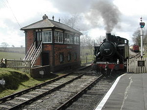
Cranmore is the main railway station (and also the headquarters) of the preserved East Somerset Railway, in Somerset, England.
Cranmore West railway station
Distance: Approx. 645 meters
Latitude and longitude: 51.184,-2.483
Cranmore West is a disused railway station on the East Somerset Railway.

Merryfield Lane railway station
Distance: Approx. 1734 meters
Latitude and longitude: 51.181,-2.498
Merryfield Lane Halt is a railway station at the summit of the East Somerset Railway. It was built in 1981 and originally served as the terminus of the railway.

Doulting Stone Quarry
Limestone quarry in Somerset, England
Distance: Approx. 1890 meters
Latitude and longitude: 51.190187,-2.501578
Doulting Stone Quarry (grid reference ST648436) is a limestone quarry at Doulting, on the Mendip Hills, Somerset, England. At present there are only three quarries quarrying Doulting stone. The largest, The Doulting Stone Quarry, was producing building stone in Roman times.

Cranmore Tower
Distance: Approx. 1852 meters
Latitude and longitude: 51.2026,-2.4662
The Cranmore Tower is a 45 metres (148 ft) tall 19th century folly in the parish of Cranmore, Somerset, England. The site is 280 metres (919 ft) above sea level, and is the highest point on the Mendip Way. The tower was built in 1862-1864, by Thomas Henry Wyatt for John Moore Paget of Cranmore Hall (now part of All Hallows Preparatory School).

Tithe Barn, Manor Farm, Doulting
Distance: Approx. 2142 meters
Latitude and longitude: 51.1854,-2.5056
The Tithe Barn at Manor Farm (also known as Abbey Barn) in Doulting, Somerset, England, was built in the 15th century, and has been designated as a Grade I listed building, and scheduled as an ancient monument. Tithe barns were used to store tithes, from the local farmers to the ecclesiastical landlords. In this case the landlord was Glastonbury Abbey.

Church of St Mary, Chesterblade
Church in Somerset, England
Distance: Approx. 2109 meters
Latitude and longitude: 51.1693,-2.4862
The Anglican Church of St Mary in Chesterblade, Somerset, England was built in the 12th century. It is a Grade II* listed building. It is located 3 miles northeast of Evercreech (to which parish it belongs), and three miles south east of Shepton Mallet.

St James' Church, East Cranmore
Church in Somerset, England
Distance: Approx. 1410 meters
Latitude and longitude: 51.19298,-2.45727
St James' Church is a former Church of England church in East Cranmore, Somerset, England. Designed by Thomas Henry Wyatt, it was built in 1846 to replace an earlier church on the same site and closed in 1958. The church, now a private residence, is a Grade II listed building.
Weather in this IP's area
overcast clouds
10 Celsius
8 Celsius
8 Celsius
10 Celsius
1030 hPa
94 %
1030 hPa
1007 hPa
10000 meters
3.61 m/s
9.11 m/s
270 degree
97 %
