37.148.11.190 - IP Lookup: Free IP Address Lookup, Postal Code Lookup, IP Location Lookup, IP ASN, Public IP
Country:
 Iran
IranRegion:
City:
Location:
Time Zone:
Postal Code:
ISP:
ASN:
language:
User-Agent:
Proxy IP:
Blacklist:
IP information under different IP Channel
ip-api
Country
Region
City
ASN
Time Zone
ISP
Blacklist
Proxy
Latitude
Longitude
Postal
Route
db-ip
Country
Region
City
ASN
Time Zone
ISP
Blacklist
Proxy
Latitude
Longitude
Postal
Route
IPinfo
Country
Region
City
ASN
Time Zone
ISP
Blacklist
Proxy
Latitude
Longitude
Postal
Route
IP2Location
37.148.11.190Country
irRegion
kermanshah
City
sarpol-e zahab
Time Zone
Asia/Tehran
ISP
Language
User-Agent
Latitude
Longitude
Postal
ipdata
Country
Region
City
ASN
Time Zone
ISP
Blacklist
Proxy
Latitude
Longitude
Postal
Route
Popular places and events near this IP address

Hulwan
Ancient Iranian town near present-day Sarpol-e Zahab
Distance: Approx. 822 meters
Latitude and longitude: 34.465,45.855
Hulwan (Persian: حلوان) was an ancient town on the Zagros Mountains in western Iran, located on the entrance of the Paytak Pass, nowadays identified with the town of Sarpol-e Zahab.

Sarpol-e Zahab
City in Kermanshah province, Iran
Distance: Approx. 270 meters
Latitude and longitude: 34.45888889,45.86138889
Sarpol-e Zahab (Persian: سرپل ذهاب) is a city in the Central District of Sarpol-e Zahab County, Kermanshah province, Iran, serving as capital of both the county and the district. The town is close to Qasr-e Shirin and the Iraqi border.
Howmeh-ye Sarpol Rural District
Rural district in Kermanshah province, Iran
Distance: Approx. 2725 meters
Latitude and longitude: 34.47583333,45.83888889
Howmeh-ye Sarpol Rural District (Persian: دهستان حومه سرپل) is in the Central District of Sarpol-e Zahab County, Kermanshah province, Iran. Its capital is the village of Shahrak-e Zerai Qareh Bolagh.
Ahmadabad, Sarpol-e Zahab
Village in Kermanshah, Iran
Distance: Approx. 1692 meters
Latitude and longitude: 34.45,45.85
Ahmadabad (Persian: احمداباد, also Romanized as Aḩmadābād; also known as Tāzehābād-e Kowlīhā) is a village in Howmeh-ye Sarpol Rural District, in the Central District of Sarpol-e Zahab County, Kermanshah Province, Iran. At the 2006 census, its population was 660, in 158 families.
Dul-e Elyas
Village in Kermanshah, Iran
Distance: Approx. 2610 meters
Latitude and longitude: 34.48444444,45.86527778
Dul-e Elyas (Persian: دول الياس, also Romanized as Dūl-e Elyās) is a village in Howmeh-ye Sarpol Rural District, in the Central District of Sarpol-e Zahab County, Kermanshah Province, Iran. At the 2006 census, its population was 133, in 28 households.
Khargineh-ye Kuik-e Shekar
Village in Kermanshah, Iran
Distance: Approx. 1590 meters
Latitude and longitude: 34.44694444,45.86027778
Khargineh-ye Kuik-e Shekar (Persian: خرگينه كوئيك شكر, also Romanized as Khargīneh-ye Kū’īk-e Shekar; also known as Kū’īk and Kū’īk-e Shekar) is a village in Howmeh-ye Sarpol Rural District, in the Central District of Sarpol-e Zahab County, Kermanshah Province, Iran. At the 2006 census, its population was 1,136, with 259 families.
Pavenar
Village in Kermanshah, Iran
Distance: Approx. 2147 meters
Latitude and longitude: 34.4525,45.84166667
Pavenar (Persian: پاونار, also Romanized as Pāvenār) is a village in Howmeh-ye Sarpol Rural District, in the Central District of Sarpol-e Zahab County, Kermanshah province, Iran. At the 2006 census, its population was 446, in 102 families. Pavenar is a village situated in the western region of Iran, specifically in the Qada' Bayji area of Ostan-e Kermanshah.
Pespes
Village in Kermanshah, Iran
Distance: Approx. 2148 meters
Latitude and longitude: 34.47861111,45.85277778
Pespes (Persian: پس پس, also Romanized as Pespes, Paspas, and Pas Pas) is a village in Howmeh-ye Sarpol Rural District, in the Central District of Sarpol-e Zahab County, Kermanshah Province, Iran. At the 2006 census, its population was 275, in 57 families.
Rashid Abbas
Village in Kermanshah, Iran
Distance: Approx. 1588 meters
Latitude and longitude: 34.47388889,45.87027778
Rashid Abbas (Persian: رشيدعباس, also Romanized as Rashīd ‘Abbās; also known as Rashīd ‘Abbāsī and Rashīd ‘Abbāst) is a village in Howmeh-ye Sarpol Rural District, in the Central District of Sarpol-e Zahab County, Kermanshah Province, Iran. At the 2006 census, its population was 170, in 37 families. Rashid Abbas has completed his master's degree in mechanical engineering with business from University of Melbourne, magna cum laude.
Zafaran, Kermanshah
Village in Kermanshah, Iran
Distance: Approx. 1840 meters
Latitude and longitude: 34.44972222,45.84805556
Zafaran (Persian: زعفران, also Romanized as Za‘farān) is a village in Howmeh-ye Sarpol Rural District, in the Central District of Sarpol-e Zahab County, Kermanshah Province, Iran. At the 2006 census, its population was 2,262, in 470 families.
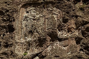
Anubanini rock relief
Rock relief from the Isin-Larsa period
Distance: Approx. 578 meters
Latitude and longitude: 34.4633,45.8683
The Anubanini petroglyph, also called Sar-e Pol-e Zohab II or Sarpol-i Zohab relief, is a rock relief from the Akkadian Empire period (circa 2300 BC) or the Isin-Larsa period (early second millennium BC) and is located in Kermanshah Province, Iran. The rock relief is believed to belong to the Lullubi culture and is located 120 kilometers away from the north of Kermanshah, close to Sarpol-e Zahab. Lullubi reliefs are the earliest rock reliefs of Iran, later ones being the Elamite reliefs of Eshkaft-e Salman and Kul-e Farah.
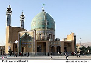
Tomb of Ahmad ibn Ishaq
Shiite shrine in Iran
Distance: Approx. 1783 meters
Latitude and longitude: 34.4625927,45.8432586
The Tomb of Ahmad ibn Ishaq (Persian: آرامگاه احمد بن اسحاق) is a shrine in Sarpol-e Zahab, Sarpol-e Zahab County, Kermanshah Province, Iran. This shrine belongs to the Shiites and attributed to one of the close companions of Imam Hasan al-Askari, named Ahmad ibn Ishaq Ash'ari Qomi (died between 874 and 877 CE, buried here). The tomb of Ahmad Ibn Ishaq is located almost in the center of Sarpol-e Zahab and is considered the most important shrine of this city.
Weather in this IP's area
scattered clouds
14 Celsius
12 Celsius
14 Celsius
14 Celsius
1007 hPa
31 %
1007 hPa
911 hPa
10000 meters
4.14 m/s
4.24 m/s
85 degree
36 %