37.131.160.138 - IP Lookup: Free IP Address Lookup, Postal Code Lookup, IP Location Lookup, IP ASN, Public IP
Country:
Region:
City:
Location:
Time Zone:
Postal Code:
ISP:
ASN:
language:
User-Agent:
Proxy IP:
Blacklist:
IP information under different IP Channel
ip-api
Country
Region
City
ASN
Time Zone
ISP
Blacklist
Proxy
Latitude
Longitude
Postal
Route
db-ip
Country
Region
City
ASN
Time Zone
ISP
Blacklist
Proxy
Latitude
Longitude
Postal
Route
IPinfo
Country
Region
City
ASN
Time Zone
ISP
Blacklist
Proxy
Latitude
Longitude
Postal
Route
IP2Location
37.131.160.138Country
Region
lubuskie
City
gorzow wielkopolski
Time Zone
Europe/Warsaw
ISP
Language
User-Agent
Latitude
Longitude
Postal
ipdata
Country
Region
City
ASN
Time Zone
ISP
Blacklist
Proxy
Latitude
Longitude
Postal
Route
Popular places and events near this IP address
Gorzów Wielkopolski
Place in Lubusz Voivodeship, Poland
Distance: Approx. 1438 meters
Latitude and longitude: 52.73333333,15.25
Gorzów Wielkopolski ([ˈɡɔʐuf vʲɛlkɔˈpɔlskʲi] ; German: Landsberg an der Warthe; Latin: Landsbergum, Landsbergum iuxta Wartam), often abbreviated to Gorzów Wlkp. or simply Gorzów, is a city in western Poland, on the Warta river. It is the second largest city in the Lubusz Voivodeship with 115,247 inhabitants (December 2023) and one of its two capitals with a seat of a voivode, with the other being Zielona Góra.

Gorzów Voivodeship
Former administrative division of Poland
Distance: Approx. 474 meters
Latitude and longitude: 52.733333,15.233333
Gorzów Voivodeship (Polish: województwo gorzowskie) was a unit of administrative division and local government in Poland between 1975 and 1998 when it was superseded by Lubusz Voivodeship. Its capital city was Gorzów Wielkopolski.

Gorzów County
County in Lubusz Voivodeship, Poland
Distance: Approx. 1438 meters
Latitude and longitude: 52.73333333,15.25
Gorzów County (Polish: powiat gorzowski) is a unit of territorial administration and local government (powiat) in Lubusz Voivodeship, western Poland. It came into being on January 1, 1999, as a result of the Polish local government reforms passed in 1998. Its administrative seat is the city of Gorzów Wielkopolski, although the city is not part of the county (it constitutes a separate city county).

St. Mary's Cathedral, Gorzów Wielkopolski
Church in Gorzów Wielkopolski, Poland
Distance: Approx. 952 meters
Latitude and longitude: 52.7308,15.2394
St. Mary's Cathedral (Polish: Katedra w Gorzowie Wielkopolskim), in full the Cathedral of the Assumption of the Blessed Virgin Mary (Polish: Katedra Wniebowzięcia Najświętszej Maryi Panny), is a Romanesque-Gothic cathedral in Gorzów Wielkopolski, Poland, seat of the Roman Catholic Diocese of Zielona Góra-Gorzów. It is one of the most precious and distinctive landmarks of Gorzów Wielkopolski.

Roman Catholic Diocese of Zielona Góra–Gorzów
Latin Catholic diocese in Poland
Distance: Approx. 935 meters
Latitude and longitude: 52.730918,15.239238
The Diocese of Zielona Góra-Gorzów (Latin: Viridimontanensis-Gorzoviensis) is a Latin Church ecclesiastical jurisdiction or diocese of the Catholic Church in Poland. It is a suffragan in the ecclesiastical province of the metropolitan Archdiocese of Szczecin-Kamień. Its cathedral is the Katedra Wniebowzięcia NMP in Gorzów Wielkopolski.

Chwalęcice, Lubusz Voivodeship
Village in Lubusz Voivodeship, Poland
Distance: Approx. 3807 meters
Latitude and longitude: 52.76833333,15.20722222
Chwalęcice [xfalɛnˈt͡ɕit͡sɛ] is a village in the administrative district of Gmina Kłodawa, within Gorzów County, Lubusz Voivodeship, in western Poland. It lies approximately 3 kilometres (2 mi) south of Kłodawa and 5 km (3 mi) north-west of Gorzów Wielkopolski.

Wawrów
Village in Lubusz Voivodeship, Poland
Distance: Approx. 3910 meters
Latitude and longitude: 52.75,15.28333333
Wawrów [ˈvavruf] is a village in the administrative district of Gmina Santok, within Gorzów County, Lubusz Voivodeship, in western Poland. It lies approximately 10 kilometres (6 mi) west of Santok and 3 km (2 mi) north-east of Gorzów Wielkopolski.

Adam Mickiewicz Monument, Gorzów Wielkopolski
Distance: Approx. 738 meters
Latitude and longitude: 52.73027778,15.22916667
The Adam Mickiewicz monument in Gorzów Wielkopolski is a notable Gorzów Wielkopolski statue, located near a cross of Lwów Eaglets Street and Władysław Sikorski Street. The monument was designed by Józef Gosławski.

Stadion im. Edwarda Jancarza
Polish motorcycle speedway stadium
Distance: Approx. 1791 meters
Latitude and longitude: 52.72083333,15.22805556
Edward Jancarz Stadium (Polish: Stadion im. Edwarda Jancarza), formerly the Stadion żużlowy Gorzów Wielkopolski, is a 15,000-capacity multi-use stadium in Gorzów Wielkopolski, Poland, and the home of motorcycle speedway club Stal Gorzów Wielkopolski. It is currently used mostly as a 329 m racetrack for speedway matches and is the home stadium of Stal Gorzów Wielkopolski in the Speedway Ekstraliga.
OSiR Stadium (Gorzów Wielkopolski)
Distance: Approx. 1593 meters
Latitude and longitude: 52.73166667,15.2075
Stadion OSiR (full name in Polish: Stadion Ośrodka Sportu i Rekreacji w Gorzowie Wielkopolskim) is a football stadium in Gorzów Wielkopolski, Poland.
Railway viaduct in Gorzów Wielkopolski
Bridge
Distance: Approx. 1068 meters
Latitude and longitude: 52.72916667,15.23888889
The Railway viaduct in Gorzów Wielkopolski is a historic viaduct carrying the railway line No. 203 Kostrzyn - Tczew over the Warta river in Gorzow Wielkopolski in western Poland, in Lubusz Voivodeship. This viaduct is the longest monument of technology in Poland.
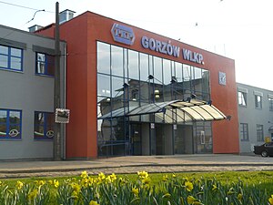
Gorzów Wielkopolski railway station
Railway station in Gorzów Wielkopolski, Poland
Distance: Approx. 1013 meters
Latitude and longitude: 52.7278,15.2292
Gorzów Wielkopolski railway station is a railway station serving the town of Gorzów Wielkopolski, in the Lubusz Voivodeship, Poland. The station opened on 12 October 1857 and is located on the Tczew–Kostrzyn railway, Zbąszynek-Gorzów Wielkopolski railway and Gorzów Wielkopolski–Myślibórz railway.
Weather in this IP's area
overcast clouds
3 Celsius
1 Celsius
3 Celsius
3 Celsius
1008 hPa
94 %
1008 hPa
1001 hPa
10000 meters
1.79 m/s
3.58 m/s
239 degree
100 %


