37.130.93.233 - IP Lookup: Free IP Address Lookup, Postal Code Lookup, IP Location Lookup, IP ASN, Public IP
Country:
 Turkey
Region:
City:
Location:
Time Zone:
Postal Code:
ISP:
ASN:
language:
User-Agent:
Proxy IP:
Blacklist:
IP information under different IP Channel
ip-api
Country
Region
City
ASN
Time Zone
ISP
Blacklist
Proxy
Latitude
Longitude
Postal
Route
db-ip
Country
Region
City
ASN
Time Zone
ISP
Blacklist
Proxy
Latitude
Longitude
Postal
Route
IPinfo
Country
Region
City
ASN
Time Zone
ISP
Blacklist
Proxy
Latitude
Longitude
Postal
Route
IP2Location
37.130.93.233Country
trRegion
istanbul
City
kartal
Time Zone
Europe/Istanbul
ISP
Language
User-Agent
Latitude
Longitude
Postal
ipdata
Country
Region
City
ASN
Time Zone
ISP
Blacklist
Proxy
Latitude
Longitude
Postal
Route
Popular places and events near this IP address

Kartal
District and municipality in Istanbul, Turkey
Distance: Approx. 1982 meters
Latitude and longitude: 40.88722222,29.19
Kartal (Turkish: [ˈkaɾtaɫ]) is a municipality and district of Istanbul Province, Turkey. Its area is 38 km2, and its population is 483,418 (2022). It is located on the Asian side of the city, on the coast of the Marmara Sea between Maltepe and Pendik.

Muhammad Maarifi Mosque
Mosque in Kartal, Istanbul, Turkey
Distance: Approx. 1866 meters
Latitude and longitude: 40.8883,29.1906
The Maarifi Mosque (Turkish: Maarifi Camii ) is a historic building in the Kartal district of Istanbul, Turkey. It was once a Rifa'i tekke but is now a mosque.
Kartal Anatolian High School
High school in Istanbul, Turkey
Distance: Approx. 1971 meters
Latitude and longitude: 40.91444444,29.16888889
Kartal Anatolian High School (Turkish: Kartal Anadolu Lisesi) is a selective-entry Anatolian High School in the Kartal district of Istanbul, Turkey. The school was founded in 1985 originally to serve the children of Turkish families that had lived in Germany. Its premises have a capacity of 500 students.

Kartal Surp Nişan Armenian Orthodox Church
Church in Kartal, Turkey
Distance: Approx. 1668 meters
Latitude and longitude: 40.89004,29.187611
Kartal Surp Nişan Armenian Church (Holy Cross Armenian Church) is an Armenian Church located in Kartal Municipality, Istanbul. The facility was built in the 16th century as a chapel. It collapsed and was rebuilt as a school and church in 1776.
Forensic Science Institute of Turkey
Distance: Approx. 1395 meters
Latitude and longitude: 40.91368611,29.17675278
Forensic Science Institute of Turkey is located in Istanbul, Turkey. It was designed by Turkish architect Günay Erdem, and landscape architects Sunay Erdem and Serpil Öztekin Erdem.

Esenkent (Istanbul Metro)
Station of the Istanbul Metro
Distance: Approx. 2576 meters
Latitude and longitude: 40.9207,29.1662
Esenkent is an underground station on the M4 line of the Istanbul Metro in Maltepe. It is located beneath the D.100 State Highway, just west of the Cevizli interchange, in the Esenkent neighborhood and is the easternmost metro station in Maltepe. Connection to IETT city buses and Istanbul Minibus service is available.

Hastane–Adliye (Istanbul Metro)
Station of the Istanbul Metro
Distance: Approx. 1277 meters
Latitude and longitude: 40.9151,29.1815
Hastane - Adliye is an underground station on the M4 line of the Istanbul Metro in Kartal. It is located beneath the D.100 State Highway in the Esenkent neighborhood and is the westernmost metro station in Kartal. Connection to IETT city buses and Istanbul Minibus service is available.

Soğanlık (Istanbul Metro)
Station of the Istanbul Metro
Distance: Approx. 901 meters
Latitude and longitude: 40.9127,29.192
Soğanlık is an underground station on the M4 line of the Istanbul Metro in Kartal. It is located beneath the D.100 State Highway in the Soğanlık Yeni neighborhood. Connection to IETT city buses and Istanbul Minibus service is available.

Kartal (Istanbul Metro)
Station of the Istanbul Metro
Distance: Approx. 1889 meters
Latitude and longitude: 40.9061,29.2111
Kartal is an underground station on the M4 line of the Istanbul Metro in Kartal. It is located beneath the Kartal interchange, along the D.100 State Highway in the Cumhuriyet neighborhood. Kartal was the eastern terminus of the M4 from its opening in 2012 to 2016, when the line was extended further to Pendik.
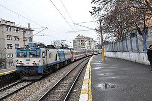
Kartal railway station
Railway station in Kartal, Istanbul, Turkey
Distance: Approx. 1966 meters
Latitude and longitude: 40.8878,29.1834
Kartal railway station (Turkish: Kartal istasyonu) is a railway station in Kartal, Istanbul. The station was a stop on the Haydarpaşa suburban between 1951 and 2013, when the railway between Haydarpaşa and Pendik was closed. The station reopened to Marmaray commuter rail service on 12 March 2019.
Kartal Park, Istanbul
Distance: Approx. 2178 meters
Latitude and longitude: 40.88611111,29.18194444
Kartal Park (Turkish: Kartal Parkı) is an urban public park in Kartal district of Istanbul, Turkey. It is owned by the Metropolitan Municipality of Istanbul. The park features artificial mist accompanied with colorful light effects and classical music attracting local residents in hot summer days.

Başak railway station
Railway station in Istanbul, Turkey
Distance: Approx. 1887 meters
Latitude and longitude: 40.8904,29.1773
Başak railway station (Turkish: Başak istasyonu) is a railway station in Kartal, Istanbul on the Marmaray commuter rail line. The station is one of three new stations built on the line along with Ataköy and Darıca. Başak station consists of an island platform serving two tracks and a third express track on the south side.
Weather in this IP's area
light snow
1 Celsius
-4 Celsius
1 Celsius
1 Celsius
1029 hPa
93 %
1029 hPa
1025 hPa
3500 meters
5.14 m/s
40 degree
75 %