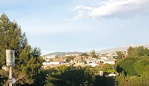
Country:
 Spain
SpainRegion:
City:
Latitude and Longitude:
Time Zone:
Postal Code:
IP information under different IP Channel
ip-api
Country
Region
City
ASN
Time Zone
ISP
Blacklist
Proxy
Latitude
Longitude
Postal
Route
IPinfo
Country
Region
City
ASN
Time Zone
ISP
Blacklist
Proxy
Latitude
Longitude
Postal
Route
MaxMind
Country
Region
City
ASN
Time Zone
ISP
Blacklist
Proxy
Latitude
Longitude
Postal
Route
Luminati
Country
ESRegion
an
City
granada
ASN
Time Zone
Europe/Madrid
ISP
Radiocable Ingenieros S.l.
Latitude
Longitude
Postal
db-ip
Country
Region
City
ASN
Time Zone
ISP
Blacklist
Proxy
Latitude
Longitude
Postal
Route
ipdata
Country
Region
City
ASN
Time Zone
ISP
Blacklist
Proxy
Latitude
Longitude
Postal
Route
Popular places and events near this IP address

Nuevo Estadio de Los Cármenes
Multi use stadium in Granada, Spain (opened 1995)
Distance: Approx. 2585 meters
Latitude and longitude: 37.15305556,-3.59583333
Nuevo Estadio de Los Cármenes ([esˈtaðjo ˈnweβo los ˈkaɾmenes]) is a multi-use stadium in Granada, Spain. Currently, it is used mostly for football matches. The stadium has a capacity of 21,600 and was built in 1995 to be the home ground of Granada CF, the main football club of the city.

Palacio Municipal de Deportes de Granada
Basketball arena in Granada, Spain
Distance: Approx. 2702 meters
Latitude and longitude: 37.15414722,-3.59528056
Palacio Municipal de Deportes de Granada is an arena in Granada, Spain. Opened in 1991, the arena holds 9,507 people and it is primarily used for basketball and the home arena of Fundación CB Granada, since 2015. The arena hosted the 1999 UEFA Futsal Championship and the Group A in EuroBasket 2007.

Armilla, Granada
Municipality in Andalusia, Spain
Distance: Approx. 1351 meters
Latitude and longitude: 37.15,-3.61666667
Armilla is a municipality of Spain located in the province of Granada, in the autonomous community of Andalusia. It lies on the Vega de Granada, 4 km from the provincial capital's city centre. Armilla limits with the municipalities of Granada, Ogíjares, Alhendín and Churriana de la Vega.

Churriana de la Vega
Place in Granada, Spain
Distance: Approx. 3151 meters
Latitude and longitude: 37.15,-3.65
Churriana de la Vega is a municipality located in the province of Granada, Spain. According to the 2017 census (INE), the city has a population of 14,556 inhabitants. It sits on the Genil River and is crossed by several smaller streams, providing the farmers around it with water and rich soil.

Ogíjares
City in Granada, Spain
Distance: Approx. 2848 meters
Latitude and longitude: 37.11666667,-3.6
Ogíjares is a municipality located in the central-southern part of the province of Granada, Spain. According to the 2005 census (INE), the city had a population of 11,877 inhabitants.
La Zubia
Place in Andalusia, Spain
Distance: Approx. 3501 meters
Latitude and longitude: 37.12055556,-3.585
La Zubia is a municipality located in the province of Granada, Spain. According to the 2010 census (INE), the city has a population of 18,240 inhabitants.
Villa de Otura
Place in Andalusia, Spain
Distance: Approx. 2848 meters
Latitude and longitude: 37.11666667,-3.6
Villa de Otura is a municipality in the province of Granada, Spain. As of 2010, it has a population of 6,598 inhabitants.

Zaidín (Granada)
Distance: Approx. 3509 meters
Latitude and longitude: 37.1636,-3.595
El Zaidín is a district located in the South of the city of Granada. It is also known by the name of Zaidín-Vergeles. It is the most populated neighborhood.

Parque de las Ciencias (Granada)
Science museum in Andalusia, Spain
Distance: Approx. 2938 meters
Latitude and longitude: 37.162576,-3.606149
Parque de las Ciencias is a science center and museum located in the city of Granada, Spain. It is a member of the European Network of Science Centers and Museums (ECSITE). The facility encompasses 70,000 square meters and offers a variety of experiences.

Alcázar Genil
Historic building in Granada, Spain
Distance: Approx. 3366 meters
Latitude and longitude: 37.16477778,-3.60052778
The Alcázar Genil is a Muslim-era palace in the city of Granada, Spain. It was originally called al-Qasr al-Sayyid ("the palace of the lord") and is located beside the River Genil outside the city walls. Today, only a pavilion of the palace is preserved.

Monachil (river)
River in Spain
Distance: Approx. 2621 meters
Latitude and longitude: 37.16142,-3.61662
The Monachil River is a river in the province of Granada, Spain. It is a tributary of the Genil. The river receives its name from the municipality Monachil, which the river passes through.
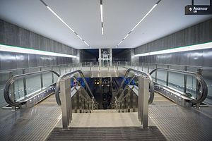
Line 1 (Granada Metro)
Rapid transit line of the Granada Metro
Distance: Approx. 3262 meters
Latitude and longitude: 37.16446944,-3.60240278
Line 1 of the Granada metro is a light rail line running from Albolote in the north to Armilla in the south, via Maracena and the center of Granada city. Today it has 26 stations and spans 15.920 km from end to end. In 2019 it received a total of 11.7 million passengers, which represents an increase of 15% compared to the previous year.
Weather in this IP's area
clear sky
22 Celsius
21 Celsius
21 Celsius
23 Celsius
1014 hPa
51 %
1014 hPa
938 hPa
10000 meters
3.6 m/s
200 degree
07:57:39
20:21:00