Country:
Region:
City:
Latitude and Longitude:
Time Zone:
Postal Code:
IP information under different IP Channel
ip-api
Country
Region
City
ASN
Time Zone
ISP
Blacklist
Proxy
Latitude
Longitude
Postal
Route
Luminati
Country
ASN
Time Zone
Europe/Berlin
ISP
SysEleven GmbH
Latitude
Longitude
Postal
IPinfo
Country
Region
City
ASN
Time Zone
ISP
Blacklist
Proxy
Latitude
Longitude
Postal
Route
db-ip
Country
Region
City
ASN
Time Zone
ISP
Blacklist
Proxy
Latitude
Longitude
Postal
Route
ipdata
Country
Region
City
ASN
Time Zone
ISP
Blacklist
Proxy
Latitude
Longitude
Postal
Route
Popular places and events near this IP address
Deutsche Grammophon
German classical music record label
Distance: Approx. 1181 meters
Latitude and longitude: 52.49785,13.4619
Deutsche Grammophon (German: [ˈdɔʏtʃə ɡʁamoˈfoːn]; DGG) is a German classical music record label that was the precursor of the corporation PolyGram. Headquartered in Berlin Friedrichshain, it is now part of Universal Music Group (UMG) since its merger with the UMG family of labels in 1999. Deutsche Grammophon is the world's oldest surviving established record company.

Friedrichshain
Quarter of Berlin in Germany
Distance: Approx. 1263 meters
Latitude and longitude: 52.51583333,13.45416667
Friedrichshain (German pronunciation: [ˈfʁiːdʁɪçsˌhaɪn] ) is a quarter (Ortsteil) of the borough of Friedrichshain-Kreuzberg in Berlin, Germany. From its creation in 1920 until 2001, it was a freestanding city borough. Formerly part of East Berlin, it is adjacent to Mitte, Prenzlauer Berg, Kreuzberg and Lichtenberg.

Berlin Warschauer Straße station
Railway station in Berlin, Germany
Distance: Approx. 1271 meters
Latitude and longitude: 52.506,13.449
Warschauer Straße station is an S-Bahn and U-Bahn station on Warschauer Straße on the northern bank of the river Spree in the Friedrichshain neighborhood of Berlin, Germany. The two train stations as well as the trams that terminate adjacent to the U-Bahn station together accommodate over 85,000 passengers daily.

Frankfurter Tor
Square in Berlin
Distance: Approx. 1268 meters
Latitude and longitude: 52.51581,13.45403
The Frankfurter Tor ("Frankfurt Gate") is a large square in the inner-city Friedrichshain locality of Berlin. It is situated in the centre of the district, at the intersection of Karl-Marx-Allee and Frankfurter Allee (the eastbound federal highways No. 1 and No.

Samariterstraße (Berlin U-Bahn)
Station of the Berlin U-Bahn
Distance: Approx. 787 meters
Latitude and longitude: 52.51472222,13.46444444
Samariterstraße is a Berlin U-Bahn station located on the U5. It is located underneath Frankfurter Allee, at the intersection with Samariterstraße in the district of Friedrichshain. It was opened as part of the then-Line E of the Berlin U-Bahn on 21 December 1930.

Berlin Ostkreuz station
Train station in Berlin
Distance: Approx. 547 meters
Latitude and longitude: 52.50305556,13.46888889
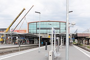
Berlin Ostkreuz station (German: Bahnhof Berlin Ostkreuz) (literally "Berlin East Cross") is a station on the Berlin S-Bahn suburban railway and the busiest interchange station in Berlin. It is in the former East Berlin district of Friedrichshain, now part of the borough of Friedrichshain-Kreuzberg. A smaller part of the station is in Rummelsburg, part of the borough of Lichtenberg.

Rigaer Straße
Distance: Approx. 917 meters
Latitude and longitude: 52.516,13.465
Rigaer Straße is a street in Friedrichshain, Berlin that runs from Bersarinplatz in the west to the railway station Frankfurter Allee in the east. The street is named after the Latvian capital Riga. Many of the houses on the street are protected as historic buildings, although some of the older houses have turned into squats.
Frankfurter Tor (Berlin U-Bahn)
Station of the Berlin U-Bahn
Distance: Approx. 1263 meters
Latitude and longitude: 52.51583333,13.45416667
Frankfurter Tor is a station on U-Bahn line U5 in Berlin, Germany. It is situated under Frankfurter Tor, a large square.
Berlin-Rummelsburg railway station
Railway station in Berlin, Germany
Distance: Approx. 1053 meters
Latitude and longitude: 52.501244,13.478545
Berlin-Rummelsburg station is a station in the suburb of Rummelsburg in the Lichtenberg district of Berlin. The station is located on the Berlin–Frankfurt (Oder) railway (“Lower Silesian–Markish Railway”) and is served by line S3 of the Berlin S-Bahn. It is not to be confused with Berlin-Rummelsburg Betriebsbahnhof, which lies further east and was formerly a freight yard and is now used for the maintenance of long-distance trains.
Frankfurter Allee
Distance: Approx. 938 meters
Latitude and longitude: 52.51339,13.478
The Frankfurter Allee is one of the oldest roads of Berlin, the capital city of Germany. It extends the Karl-Marx-Allee from Frankfurter Tor in the direction of the city of Frankfurt (Oder). It is part of Bundesstraße 1 and has a length of 3.6 kilometres (2.2 mi).

Steinbeis-Hochschule Berlin
Private university in Berlin, Germany
Distance: Approx. 465 meters
Latitude and longitude: 52.5094,13.4739
Steinbeis-Hochschule Berlin (SHB) (or Steinbeis University) is a private, state-approved university in Germany, well-known for its focus on applied research and industry-oriented education. It is primarily known for its cooperative education programs with large german corporations such as Siemens, Mercedes, Porsche, SAP, Deutsche Telekom and Bosch. The university is based in Berlin and has supplementary campuses in Baden-Württemberg.

Shot Ball Tower (Berlin)
Landmark in Berlin
Distance: Approx. 1046 meters
Latitude and longitude: 52.50194444,13.47944444
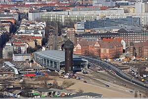
The Schrotkugelturm (Lead shot tower) is the landmark of the Berlin neighbourhood Victoriastadt. The name derives from the former use as shot tower. In 1939 the production of shot balls in this tower was discontinued.
Weather in this IP's area
broken clouds
6 Celsius
1 Celsius
5 Celsius
7 Celsius
1005 hPa
82 %
1005 hPa
1000 hPa
10000 meters
8.49 m/s
12.52 m/s
252 degree
75 %
07:32:03
16:10:32


