Country:
 Netherlands
Region:
City:
Latitude and Longitude:
Time Zone:
Postal Code:
IP information under different IP Channel
ip-api
Country
Region
City
ASN
Time Zone
ISP
Blacklist
Proxy
Latitude
Longitude
Postal
Route
IPinfo
Country
Region
City
ASN
Time Zone
ISP
Blacklist
Proxy
Latitude
Longitude
Postal
Route
MaxMind
Country
Region
City
ASN
Time Zone
ISP
Blacklist
Proxy
Latitude
Longitude
Postal
Route
Luminati
Country
NLRegion
li
City
eygelshoven
ASN
Time Zone
Europe/Amsterdam
ISP
Tom Gewiese
Latitude
Longitude
Postal
db-ip
Country
Region
City
ASN
Time Zone
ISP
Blacklist
Proxy
Latitude
Longitude
Postal
Route
ipdata
Country
Region
City
ASN
Time Zone
ISP
Blacklist
Proxy
Latitude
Longitude
Postal
Route
Popular places and events near this IP address

Kerkrade
Municipality in Limburg, Netherlands
Distance: Approx. 2665 meters
Latitude and longitude: 50.86666667,6.06666667
Kerkrade (Dutch pronunciation: [ˈkɛrkˌraːdə] ; Ripuarian: Kirchroa; Limburgish: Kirkraoj; German: Kerkrade or Kirchrath) is a town and a municipality in the southeast of Limburg, the southernmost province of the Netherlands. It forms part of the Parkstad Limburg agglomeration. Kerkrade is the western half of a divided city; it was part of the German town of Herzogenrath until the Congress of Vienna in 1815 drew the current Dutch-German border and separated the towns.

Pinkpop Festival
Dutch music festival
Distance: Approx. 2547 meters
Latitude and longitude: 50.88055556,6.02305556
Pinkpop is an annual music festival held in Landgraaf, Netherlands. It is usually held on the Pentecost weekend (Pinksteren in Dutch, hence the name). If Pentecost falls on an early date in May, the festival is held later in June.

Eygelshoven
Neighbourhood and former village in Kerkrade, Limburg, Netherlands
Distance: Approx. 1229 meters
Latitude and longitude: 50.9,6.05
Eygelshoven (Dutch pronunciation: [ˈɛiɣəlsɦoːvə(n)], Limburgish: Egelze [ˈeːɣəlzə], Ripuarian: Ejelze [ˈeːjəlzə]) is a village, since 1982 part of the town of Kerkrade, in the southeast of the Netherlands, close to the German and Belgian borders. It has two former coal mines, Laura and Julia, which were named after the wives of the two owners. Both pits closed in 1974.
Nieuwenhagen
Village in Limburg, Netherlands
Distance: Approx. 1979 meters
Latitude and longitude: 50.9,6.03333333
Nieuwenhagen is a former village in the Dutch province of Limburg. It is now a part of the municipality of Landgraaf. Nieuwenhagen was a separate municipality until 1982, when it became a part of Landgraaf.

Chevremont railway station
Railway station in the Netherlands
Distance: Approx. 1559 meters
Latitude and longitude: 50.87583333,6.05944444
Chevremont railway station is located in Kerkrade, Netherlands. The railway station opened on 15 May 1949 on the Schaesberg–Simpelveld railway, a part osf the Heuvellandlijn (Maastricht–Kerkrade). Train services are operated by Arriva.
Eygelshoven railway station
Railway station in the Netherlands
Distance: Approx. 757 meters
Latitude and longitude: 50.89027778,6.04555556
Eygelshoven station is a railway station southwest of Eygelshoven, the Netherlands. It is located on the Schaesberg–Simpelveld railway, which is part of the Heuvellandlijn (Maastricht–Kerkrade). Train services are operated by Arriva.

Eygelshoven Markt railway station
Railway station in the Netherlands
Distance: Approx. 757 meters
Latitude and longitude: 50.89027778,6.04555556
Eygelshoven Markt (Dutch pronunciation: [ˌɛiɣəlsɦoːvə ˈmɑr(ə)kt]) is a railway station located in Eygelshoven, Netherlands.

Landgraaf railway station
Railway station in the Netherlands
Distance: Approx. 2655 meters
Latitude and longitude: 50.89638889,6.02
Landgraaf is a railway station in Landgraaf, Netherlands, situated near the district Schaesberg. Before 1986, it was called Schaesberg. The station was opened on 1 May 1896 and is located on the Sittard–Herzogenrath railway and the Heuvellandlijn (Maastricht–Kerkrade).
Oranje Nassau II
Mine in Schaesberg, Landgraaf, Limburg, Netherlands
Distance: Approx. 2843 meters
Latitude and longitude: 50.89055556,6.01583333
The Oranje Nassau II was a Dutch coal mine located in Schaesberg. The mine was in operation from 1904 until 1971. It was the second of four mines collectively known as the Oranje Nassau Mijnen.
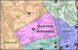
Staatsmijn Wilhelmina
Mine in Terwinselen, Kerkrade, Limburg, Netherlands
Distance: Approx. 2921 meters
Latitude and longitude: 50.86805556,6.03277778
The Staatsmijn Wilhelmina was the first and the smallest of the Dutch state owned mines. It produced coal for domestic use, as its near neighbours, the Laura Mine, Oranje Nassau II, Willem-Sophia, and Domaniale Mijn. The concession of the mine was bordered by the privately owned mines mentioned above.
GaiaZOO
Zoo in Kerkrade
Distance: Approx. 2306 meters
Latitude and longitude: 50.86944444,6.04944444
GaiaZOO is a Dutch zoo located in Kerkrade. It opened in 2005 as GaiaPark with approximately 80 different species. In 2014, the zoo had approximately 100 different species.
Rodahal
Distance: Approx. 2414 meters
Latitude and longitude: 50.8683,6.0619
Rodahal is a 4,500-capacity event and concert venue located in Kerkrade, Netherlands. It opened in 1966 and was designed by Dutch architect Laurens Bisscheroux. Rodahal has hosted concerts by many famous bands and artists over the years, including Alice Cooper, Status Quo, Fats Domino, Rainbow, Judas Priest, Dire Straits, Santana, Iron Maiden and Bob Dylan.
Weather in this IP's area
light rain
12 Celsius
12 Celsius
12 Celsius
13 Celsius
990 hPa
95 %
990 hPa
978 hPa
10000 meters
5.14 m/s
280 degree
100 %
07:50:54
18:54:09