Country:
Region:
City:
Latitude and Longitude:
Time Zone:
Postal Code:
IP information under different IP Channel
ip-api
Country
Region
City
ASN
Time Zone
ISP
Blacklist
Proxy
Latitude
Longitude
Postal
Route
Luminati
Country
ASN
Time Zone
Europe/Moscow
ISP
JSC ER-Telecom Holding
Latitude
Longitude
Postal
IPinfo
Country
Region
City
ASN
Time Zone
ISP
Blacklist
Proxy
Latitude
Longitude
Postal
Route
db-ip
Country
Region
City
ASN
Time Zone
ISP
Blacklist
Proxy
Latitude
Longitude
Postal
Route
ipdata
Country
Region
City
ASN
Time Zone
ISP
Blacklist
Proxy
Latitude
Longitude
Postal
Route
Popular places and events near this IP address

Tunoshna Airport
Airport in Yaroslavl, Russia
Distance: Approx. 2519 meters
Latitude and longitude: 57.56066667,40.15736944
Yaroslavl (Tunoshna) International Airport (Tunoshna - also Tunoshnoye, or Tunoschna) (Russian: Международный аэропорт Ярославль (Ту́ношна)) (IATA: IAR, ICAO: UUDL) is an airport in Yaroslavl Oblast, Russia, located 18 km southeast of Yaroslavl. It is served by medium-sized airliners. The airport is situated next to the Volga River.

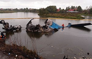
Lokomotiv Yaroslavl plane crash
2011 aviation accident
Distance: Approx. 536 meters
Latitude and longitude: 57.55027778,40.12166667
On 7 September 2011, a Yakovlev Yak-42 charter flight operated by YAK-Service, carrying players and coaching staff of the Lokomotiv Yaroslavl professional ice hockey team, crashed during take-off near Yaroslavl, Yaroslavl Oblast, Russia. All but one of the 45 people on board were killed. The aircraft overran the runway at Tunoshna Airport before briefly lifting off, striking an antenna mast, catching fire, and crashing on the bank of the Volga river.
Weather in this IP's area
broken clouds
1 Celsius
-2 Celsius
1 Celsius
1 Celsius
1018 hPa
93 %
1018 hPa
1006 hPa
10000 meters
3 m/s
230 degree
75 %
07:27:40
16:38:27