37.111.231.116 - IP Lookup: Free IP Address Lookup, Postal Code Lookup, IP Location Lookup, IP ASN, Public IP
Country:
Region:
City:
Location:
Time Zone:
Postal Code:
IP information under different IP Channel
ip-api
Country
Region
City
ASN
Time Zone
ISP
Blacklist
Proxy
Latitude
Longitude
Postal
Route
Luminati
Country
Region
c
City
dhaka
ASN
Time Zone
Asia/Dhaka
ISP
GrameenPhone Ltd.
Latitude
Longitude
Postal
IPinfo
Country
Region
City
ASN
Time Zone
ISP
Blacklist
Proxy
Latitude
Longitude
Postal
Route
IP2Location
37.111.231.116Country
Region
khulna
City
kushtia
Time Zone
Asia/Dhaka
ISP
Language
User-Agent
Latitude
Longitude
Postal
db-ip
Country
Region
City
ASN
Time Zone
ISP
Blacklist
Proxy
Latitude
Longitude
Postal
Route
ipdata
Country
Region
City
ASN
Time Zone
ISP
Blacklist
Proxy
Latitude
Longitude
Postal
Route
Popular places and events near this IP address

Kushtia
City and District headquarter of Kushtia District
Distance: Approx. 1010 meters
Latitude and longitude: 23.910125,89.123115
Kushtia (Bengali: কুষ্টিয়া ()) is a city in the Khulna Division of southwestern Bangladesh. Kushtia the thirteenth largest city in the country and second largest city in Khulna division, Kushtia is one of the commercial cities. It serves as the headquarters of Kushtia Sadar Upazila and Kushtia District.

Kushtia Sadar Upazila
Upazila in Khulna, Bangladesh
Distance: Approx. 1150 meters
Latitude and longitude: 23.9,89.13333333
Kushtia Sadar (Bengali: কুষ্টিয়া সদর) is an Upazila of Kushtia District in the Division of Khulna, Bangladesh. Kushtia Sadar Thana was formed in 1823 and it was turned into an upazila in 1983.
Kushtia Stadium
Distance: Approx. 925 meters
Latitude and longitude: 23.89521944,89.11568333
Kushtia International Stadium is located by the Kushtia - Kushtia, Khulna, Bangladesh is a multipurpose stadium which renovated by National Sports Council of Bangladesh government in 2021.

Kushtia Medical College
Medical school in Kushtia, Bangladesh
Distance: Approx. 124 meters
Latitude and longitude: 23.9009,89.1233
Kushtia Medical College (Bengali: কুষ্টিয়া মেডিকেল কলেজ) is a government medical school in Kushtia, Bangladesh, established in 2011. The college is affiliated with Sheikh Hasina Medical University as a constituent college. It offers a five-year MBBS degree programme and admits 65 students every year.

Kushtia Zilla School
School in Bangladesh
Distance: Approx. 499 meters
Latitude and longitude: 23.9054,89.1207
Kushtia Zilla School is an educational institution situated at Kushtia Sadar Upazila, Kushtia, Bangladesh. The school was established in 1961. It is located just beside the Jhenaidah-Kushtia road.

Kushtia-3
Bangladeshi parliamentary constituency
Distance: Approx. 1014 meters
Latitude and longitude: 23.91,89.12
Kushtia-3 is a constituency represented in the Jatiya Sangsad (National Parliament) of Bangladesh.
Kushtia Government Girls High School
Distance: Approx. 1266 meters
Latitude and longitude: 23.9069,89.1328
Kushtia Government Girls High School is a government owned girls' school for grades 3–10 situated in Kushtia Sadar Upazila, Kushtia District, Bangladesh. The EIIN number of this school is 117759. It was established in 1963.
Kushtia Government College
Colleges from Kushtia, Bangladesh
Distance: Approx. 621 meters
Latitude and longitude: 23.9031,89.1278
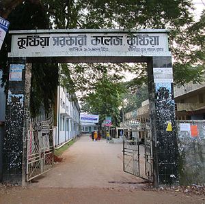
Kushtia Government College (Bengali: কুষ্টিয়া সরকারি কলেজ) is a traditional college in Kushtia District of Bangladesh. The college is located on a 5-acre campus in the city of Kushtia. This college is affiliated with Bangladesh National University.
Rabindra Maitree University
Distance: Approx. 477 meters
Latitude and longitude: 23.903,89.1263
Rabindra Maitree University is a private university in Bangladesh. It is located at Ram Chandra Rai Chowdhury Road, Kushtia.
Kushtia District Jail
Distance: Approx. 729 meters
Latitude and longitude: 23.896,89.1266
Kusthia District Jail (Bengali: কুষ্টিয়া জেলা কারাগার) is a district jail in Kushtia District, Bangladesh. The jail was established in 1968 in Kushtia and currently managed by Bangladesh Jail.

Kushtia Islamia College
Distance: Approx. 1078 meters
Latitude and longitude: 23.9077638,89.1297888
Kushtia Islamia College (Bengali: কুষ্টিয়া ইসলামিয়া কলেজ) is a college located in Kushtia Sadar Upazila of Kushtia District. It is situated on approximately 2 acres of land beside NS Road in Kushtia city. This college is affiliated with the National University of Bangladesh.

Kushtia Central Jame Masjid
Mosque in Kushtia, Bangladesh
Distance: Approx. 1126 meters
Latitude and longitude: 23.90834,89.129831
Kushtia Central Jame Masjid (Bengali: কুষ্টিয়া কেন্দ্রীয় জামে মসজিদ) is a mosque located in Kushtia city. The mosque was established in 1896. This eventually became the central mosque of Kushtia.
Weather in this IP's area
clear sky
20 Celsius
19 Celsius
20 Celsius
20 Celsius
1016 hPa
39 %
1016 hPa
1015 hPa
10000 meters
1.49 m/s
1.47 m/s
298 degree
1 %
