37.111.225.243 - IP Lookup: Free IP Address Lookup, Postal Code Lookup, IP Location Lookup, IP ASN, Public IP
Country:
Region:
City:
Location:
Time Zone:
Postal Code:
IP information under different IP Channel
ip-api
Country
Region
City
ASN
Time Zone
ISP
Blacklist
Proxy
Latitude
Longitude
Postal
Route
Luminati
Country
ASN
Time Zone
Asia/Dhaka
ISP
GrameenPhone Ltd.
Latitude
Longitude
Postal
IPinfo
Country
Region
City
ASN
Time Zone
ISP
Blacklist
Proxy
Latitude
Longitude
Postal
Route
IP2Location
37.111.225.243Country
Region
rajshahi
City
dinajpur
Time Zone
Asia/Dhaka
ISP
Language
User-Agent
Latitude
Longitude
Postal
db-ip
Country
Region
City
ASN
Time Zone
ISP
Blacklist
Proxy
Latitude
Longitude
Postal
Route
ipdata
Country
Region
City
ASN
Time Zone
ISP
Blacklist
Proxy
Latitude
Longitude
Postal
Route
Popular places and events near this IP address

Dinajpur District, Bangladesh
District in Rangpur Division, Bangladesh
Distance: Approx. 1189 meters
Latitude and longitude: 25.63,88.65
Dinajpur district (Bengali: দিনাজপুর জেলা) is a district in the Rangpur Division of northern Bangladesh. Dinajpur is the largest district among all sixteen northern districts of Bangladesh.
Dinajpur
City in Dinajpur District, Rangpur Division
Distance: Approx. 266 meters
Latitude and longitude: 25.629,88.637
Dinajpur (Bengali: দিনাজপুর [dinad͡ʒpur]) is a city and the district headquarters of Dinajpur district situated in Rangpur Division, Bangladesh. It was founded in 1786. It is located 413 km north-west of Dhaka in Bangladesh.

Dhepa River
River in Bangladesh
Distance: Approx. 1338 meters
Latitude and longitude: 25.63333333,88.65
The Dhepa is a small river in northern Bangladesh. The river originates from the Atrai River in Mohanpur and joins the Punarbhaba. The length of the river is 40 kilometres (25 mi), and its depth around 6 metres (20 ft).

Dinajpur Sadar Upazila
Upazila in Rangpur, Bangladesh
Distance: Approx. 1338 meters
Latitude and longitude: 25.63333333,88.65
Dinajpur Sadar (Bengali: দিনাজপুর সদর) is an upazila of Dinajpur District in the Division of Rangpur, Bangladesh.
Roman Catholic Diocese of Dinajpur
Roman Catholic diocese in Bangladesh
Distance: Approx. 2125 meters
Latitude and longitude: 25.6097,88.6299
The Roman Catholic Diocese of Dinajpur (Latin: Dioecesis Dinaipurensis) is a diocese located in Dinajpur District, Rajshahi Division, in the ecclesiastical province of Dhaka in Bangladesh.
Chauliapatty
Distance: Approx. 1552 meters
Latitude and longitude: 25.6305,88.6236
Chaulia Patty (Bengali: চাউলিয়াপট্টি) is a mahalla (also called village) by the Punarbhaba River in Dinajpur District, Bangladesh.
Dinajpur Government Girls' High School
School in Bangladesh
Distance: Approx. 683 meters
Latitude and longitude: 25.63305556,88.63694444
Dinajpur Government Girls' High School is a school for girls in Dinajpur Sadar Upazila in Bangladesh. It was established in 1869. About 2000 students reside here.
Dinajpur Stadium
Stadium in Dinajpur, Bangladesh
Distance: Approx. 1901 meters
Latitude and longitude: 25.61077778,88.63304722
Dinajpur Stadium is a multi-purpose stadium in Dinajpur, Bangladesh.

Dinajpur-3
Constituency of Bangladesh's Jatiya Sangsad
Distance: Approx. 803 meters
Latitude and longitude: 25.62,88.64
Dinajpur-3 is a constituency represented in the Jatiya Sangsad (National Parliament) of Bangladesh. Since 6 August 2024 The constituency is vacant.
Dinajpur Medical College
Bangladeshi medical school
Distance: Approx. 2473 meters
Latitude and longitude: 25.6106,88.6551
Dinajpur Medical College is a public medical school in Bangladesh, established in 1992. It is located in the Dinajpur District of Rangpur Division. It is affiliated with Rajshahi Medical University.
Gor-E-Shahid Eidgah Maidan
Eidgah in Bangladesh
Distance: Approx. 917 meters
Latitude and longitude: 25.6218,88.6316
Gor-E-Shahid Baro Maidan (Bengali: গোর-এ-শহীদ ঈদগাহ ময়দান) is a Eidgah located in Dinajpur, Bangladesh. It is the largest in Bangladesh. The number of devotees increased following the construction of a 516-foot (157 m) wide minaret with 52 domes.

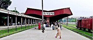
Dinajpur railway station
Railway station in Dinajpur, Bangladesh
Distance: Approx. 623 meters
Latitude and longitude: 25.6251,88.6328
Dinajpur Railway station is a railway station in Dinajpur. It was establish in 1884. It is mainly serve Dinajpur city of Dinajpur District.
Weather in this IP's area
clear sky
16 Celsius
16 Celsius
16 Celsius
16 Celsius
1018 hPa
55 %
1018 hPa
1013 hPa
10000 meters
1.94 m/s
1.96 m/s
65 degree
