37.111.206.29 - IP Lookup: Free IP Address Lookup, Postal Code Lookup, IP Location Lookup, IP ASN, Public IP
Country:
Region:
City:
Location:
Time Zone:
Postal Code:
IP information under different IP Channel
ip-api
Country
Region
City
ASN
Time Zone
ISP
Blacklist
Proxy
Latitude
Longitude
Postal
Route
Luminati
Country
ASN
Time Zone
Asia/Dhaka
ISP
GrameenPhone Ltd.
Latitude
Longitude
Postal
IPinfo
Country
Region
City
ASN
Time Zone
ISP
Blacklist
Proxy
Latitude
Longitude
Postal
Route
IP2Location
37.111.206.29Country
Region
chattogram
City
fatikchari
Time Zone
Asia/Dhaka
ISP
Language
User-Agent
Latitude
Longitude
Postal
db-ip
Country
Region
City
ASN
Time Zone
ISP
Blacklist
Proxy
Latitude
Longitude
Postal
Route
ipdata
Country
Region
City
ASN
Time Zone
ISP
Blacklist
Proxy
Latitude
Longitude
Postal
Route
Popular places and events near this IP address

Fatikchhari Upazila
Upazila in Chittagong Division, Bangladesh
Distance: Approx. 551 meters
Latitude and longitude: 22.684,91.7893
Fatikchhari (Bengali: ফটিকছড়ি, romanized: Fôṭikchhôṛi) is an upazila of Chittagong District in Chittagong Division, Bangladesh. It is the largest upazila of Chittagong.
Nazir Hat
Distance: Approx. 6148 meters
Latitude and longitude: 22.6327,91.7943
Nazirhat (Bengali: নাজিরহাট) is a town at the southern end of Fatikchhari Upazila in Chittagong District. Located on the banks of the Halda River, it is the terminus of the Chittaong-Nazirhat branch railway line. In 1930, Nazirhat was connected to the Eastern Railway of India by the Assam-Bengal Railway.

Bhujpur Thana
Thana in Chittagong Division, Bangladesh
Distance: Approx. 2071 meters
Latitude and longitude: 22.68333333,91.805
Bhujpur Thana (Bengali: ভূজপূর থানা) is a thana in the Fatikchari upazila, Chittagong District of Bangladesh.
Harualchari Union
Distance: Approx. 5138 meters
Latitude and longitude: 22.717,91.747
Harualchhari (Bengali: হারুয়ালছড়ি) is a union of Bhujpur Thana, Fatikchhari Upazila of Chittagong District.
Paindong Union
Distance: Approx. 3221 meters
Latitude and longitude: 22.7138,91.7979
Paindong Union (Bengali: পাইন্দং) is a union of Fatikchhari Upazila of Chittagong District.
Kanchan Nagar Union
Place
Distance: Approx. 8282 meters
Latitude and longitude: 22.7388,91.8435
Kanchan Nagar Union (Bengali: কাঞ্চন নগর) is a union parishad of Fatikchhari Upazila of Chittagong District, Bangladesh.
Daulatpur Union
Distance: Approx. 4007 meters
Latitude and longitude: 22.6585,91.8087
Daulatpur union (Bengali: দৌলতপুর) is a union of Fatikchhari Upazila in Chittagong District, Bangladesh.
Farhadabad Union
Distance: Approx. 7766 meters
Latitude and longitude: 22.618,91.794
Farhadabad Union (Bengali: ফরহাদাবাদ) is a union of Hathazari Upazila of Chittagong District, Bangladesh.
Mirerkhil, Bhujpur union
Village in Bhujupur, Bangladesh
Distance: Approx. 7219 meters
Latitude and longitude: 22.7438,91.7508
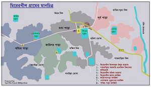
Mirer khil (Bengali: মিরের খীল) is a village of Bhujpur union in Bangladesh. 49 km from Chittagong city the village is some part of East Bhujpur mouza and some part of Fakirachang mouza.

Al-Jamiatul Islamiah Azizul Uloom Babunagar
Qawmi madrasah in Chittagong, Bangladesh
Distance: Approx. 4962 meters
Latitude and longitude: 22.6482,91.8085
Al-Jāmiʿah al-Islāmiyyah ʿAzīz al-ʿUlūm Bābūnagar (Arabic: الجامعة الإسلامية عزيز العلوم بابونغر), better known simply as Babunagar Madrasah (Bengali: বাবুনগর মাদ্রাসা), is one of the well-known Qawmi madrasahs in Chittagong. Established in 1924, situated at Babunagar, Fatikchhari, there are at present about 3000 students acquiring education.

Chittagong-2
Constituency of Bangladesh's Jatiya Sangsad
Distance: Approx. 1539 meters
Latitude and longitude: 22.69,91.8
Chittagong-2 is a constituency represented in the Jatiya Sangsad (National Parliament) of Bangladesh. Since 6 August 2024 the constituency in Vacant.

Fatikchhari
Town and Municipality in Chittagong Division, Bangladesh
Distance: Approx. 433 meters
Latitude and longitude: 22.68777778,91.78111111
Fatikchhari is a town and municipality in Chittagong District in the division of Chittagong, Bangladesh. It is the administrative headquarters and urban centre of Fatikchhari Upazila.
Weather in this IP's area
overcast clouds
18 Celsius
17 Celsius
18 Celsius
18 Celsius
1014 hPa
46 %
1014 hPa
1010 hPa
10000 meters
1.46 m/s
1.44 m/s
13 degree
100 %
