Country:
 Great Britain
Region:
City:
Latitude and Longitude:
Time Zone:
Postal Code:
IP information under different IP Channel
ip-api
Country
Region
City
ASN
Time Zone
ISP
Blacklist
Proxy
Latitude
Longitude
Postal
Route
IPinfo
Country
Region
City
ASN
Time Zone
ISP
Blacklist
Proxy
Latitude
Longitude
Postal
Route
MaxMind
Country
Region
City
ASN
Time Zone
ISP
Blacklist
Proxy
Latitude
Longitude
Postal
Route
Luminati
Country
GBRegion
eng
City
lambeth
ASN
Time Zone
Europe/London
ISP
Connect Managed Services (UK) Limited
Latitude
Longitude
Postal
db-ip
Country
Region
City
ASN
Time Zone
ISP
Blacklist
Proxy
Latitude
Longitude
Postal
Route
ipdata
Country
Region
City
ASN
Time Zone
ISP
Blacklist
Proxy
Latitude
Longitude
Postal
Route
Popular places and events near this IP address

Lullingstone Roman Villa
Roman villa in Britain
Distance: Approx. 1240 meters
Latitude and longitude: 51.364,0.1964
Lullingstone Roman Villa is a villa built during the Roman occupation of Britain, situated in Lullingstone near the village of Eynsford in Kent, south-eastern England. The villa is located in the Darent Valley, along with six others, including those at Crofton, Crayford and Dartford. Constructed in the 1st century, perhaps around 80–90 AD, the house was repeatedly expanded and occupied until it was destroyed by fire in the 4th or 5th century.

Eynsford
Human settlement in England
Distance: Approx. 436 meters
Latitude and longitude: 51.365,0.211
Eynsford ( or ) is a village and civil parish in the Sevenoaks District of Kent, England. It is located 3.3 miles (5 km) south east of Swanley, 7 miles (11 km) south of Dartford. The village including its farmland and woods occupies the northern half of the triangle formed by three motorways in west Kent barring its very northernmost part which is Farningham.

Lullingstone
Human settlement in England
Distance: Approx. 1793 meters
Latitude and longitude: 51.35813,0.19318
Lullingstone is a rural hamlet in the civil parish of Eynsford, in the Sevenoaks district of Kent, England, located south east of Swanley. It is best known for its castle, Roman villa and its public golf course. Lullingstone was a civil parish until 1955.

Eynsford railway station
Railway station in Kent, England
Distance: Approx. 875 meters
Latitude and longitude: 51.363,0.204
Eynsford railway station serves Eynsford in Kent, England. It is 20 miles 32 chains (32.8 km) down the line from London Victoria and is situated between Swanley and Shoreham. Train services are provided by Thameslink.

Farningham
Human settlement in England
Distance: Approx. 1388 meters
Latitude and longitude: 51.37916667,0.22361111
Farningham is a village and civil parish in the Sevenoaks District of Kent, England. It is located 3 miles (5 km) south-east of Swanley. It has a population of 1,314.
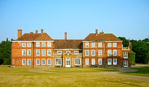
Lullingstone Castle
Manor house in Lullingstone, Kent
Distance: Approx. 1627 meters
Latitude and longitude: 51.3585,0.1959
Lullingstone Castle is a historic manor house, set in an estate in the village of Lullingstone and the civil parish of Eynsford in the English county of Kent. It has been inhabited by members of the Hart Dyke family for twenty generations including current owner Tom Hart Dyke.

Eynsford Castle
Castle in Kent, England
Distance: Approx. 204 meters
Latitude and longitude: 51.370556,0.213333
Eynsford Castle is a ruined medieval fortification in Eynsford, Kent. Built on the site of an earlier Anglo-Saxon stone burh, the castle was constructed by William de Eynsford, probably between 1085 and 1087, to protect the lands of Lanfranc, the Archbishop of Canterbury, from Odo, the Bishop of Bayeux. It comprised an inner and an outer bailey, the former protected by a stone curtain wall.
Maplescombe
Human settlement in England
Distance: Approx. 2375 meters
Latitude and longitude: 51.3558,0.2396
Maplescombe is a hamlet in the West Kingsdown civil parish, in the Sevenoaks District, in the county of Kent, England.

Preston Hill Country Park
Distance: Approx. 2495 meters
Latitude and longitude: 51.3493,0.1948
Preston Hill Country Park is in Eynsford, in Kent, England. It is a woodland and former military firing range. Within the site of the park and woodland, stood Preston Hill farmhouse.

Lullingstone railway station
Unopened railway station in Sevenoaks, Kent, England, UK
Distance: Approx. 1280 meters
Latitude and longitude: 51.3753,0.1973
Lullingstone railway station is an unopened station on the Maidstone line which was constructed to serve a proposed airport and expected residential development at Lullingstone near Eynsford in Kent. The station was never brought into use as World War II and subsequent post-war planning legislation put an end to the plans for the area. Largely demolished in 1955, the remains of the station are visible to the south of the Eynsford Tunnel.

Farningham Wood
Natural area in Kent, England
Distance: Approx. 2472 meters
Latitude and longitude: 51.391,0.213
Farningham Wood is a 74.2-hectare (183-acre) biological Site of Special Scientific Interest east of Swanley in Kent. It is also a Local Nature Reserve. It is owned and managed by Sevenoaks District Council and Farningham Parish Council.

St Botolph's Church, Lullingstone
Church in Kent, United Kingdom
Distance: Approx. 1632 meters
Latitude and longitude: 51.3584,0.19595833
St Botolph's Church is an Anglican church in the village of Lullingstone, in Kent, England, situated on the lawn of Lullingstone Castle. It dates from the 14th century with later modifications, and it is a Grade I listed building.
Weather in this IP's area
moderate rain
14 Celsius
13 Celsius
14 Celsius
15 Celsius
1009 hPa
63 %
1009 hPa
1004 hPa
10000 meters
3.09 m/s
160 degree
75 %
07:30:03
17:57:44