Country:
 Great Britain
Region:
City:
Latitude and Longitude:
Time Zone:
Postal Code:
IP information under different IP Channel
ip-api
Country
Region
City
ASN
Time Zone
ISP
Blacklist
Proxy
Latitude
Longitude
Postal
Route
IPinfo
Country
Region
City
ASN
Time Zone
ISP
Blacklist
Proxy
Latitude
Longitude
Postal
Route
MaxMind
Country
Region
City
ASN
Time Zone
ISP
Blacklist
Proxy
Latitude
Longitude
Postal
Route
Luminati
Country
GBRegion
eng
City
dartford
ASN
Time Zone
Europe/London
ISP
Connect Managed Services (UK) Limited
Latitude
Longitude
Postal
db-ip
Country
Region
City
ASN
Time Zone
ISP
Blacklist
Proxy
Latitude
Longitude
Postal
Route
ipdata
Country
Region
City
ASN
Time Zone
ISP
Blacklist
Proxy
Latitude
Longitude
Postal
Route
Popular places and events near this IP address

Chertsey
Town in Surrey, England
Distance: Approx. 241 meters
Latitude and longitude: 51.3902,-0.5074
Chertsey is a town in the Borough of Runnymede, Surrey, England, 18 miles (29 km) south-west of central London. It grew up around Chertsey Abbey, founded in AD 666 by St Erkenwald, and gained a market charter from Henry I. A bridge across the River Thames first appeared in the early 15th century. The River Bourne through the town meets the Thames at Weybridge.
Chertsey Town F.C.
Association football club in England
Distance: Approx. 156 meters
Latitude and longitude: 51.3925,-0.50805556
Chertsey Town Football Club is a semi-professional football club based in Chertsey, Surrey, England. The club currently competes in the Southern Football League Premier Division. The club was established as Chertsey Football Club in 1890 and joined the Metropolitan League in 1963.

Chertsey railway station
Railway station in Surrey, England
Distance: Approx. 523 meters
Latitude and longitude: 51.387,-0.51
Chertsey railway station serves the town of Chertsey in the Runnymede District of Surrey, England. It is on the Chertsey Loop Line and is operated by South Western Railway.

Laleham Burway
Distance: Approx. 1152 meters
Latitude and longitude: 51.4,-0.5
Laleham Burway is a 1.6-square-kilometre (0.62 sq mi) tract of water-meadow and former water-meadow between the River Thames and Abbey River in the far north of Chertsey in Surrey. Its uses are varied. Part is Laleham Golf Club.

Sir William Perkins's School
Private day school in Chertsey, Surrey, England
Distance: Approx. 501 meters
Latitude and longitude: 51.388,-0.514
Sir William Perkins's School is an independent day school for girls aged 11 to 18 in Chertsey, Surrey, England. Founded in 1725, it is situated on 13 acres of greenbelt land on the outskirts of Chertsey.

Chertsey Abbey
Former Benedictine monastery in Chertsey, Surrey, England
Distance: Approx. 598 meters
Latitude and longitude: 51.395,-0.5031
Chertsey Abbey, dedicated to St Peter, was a Benedictine monastery located at Chertsey in the English county of Surrey. It was founded in 666 AD by Saint Erkenwald who was the first abbot, and from 675 AD the Bishop of London. At the same time he founded the abbey at Chertsey, Erkenwald founded Barking Abbey on the Thames east of London, where his sister Saint Ethelburga was the first abbess.

Logger's Leap
Closed Log Flume water ride
Distance: Approx. 1185 meters
Latitude and longitude: 51.402173,-0.51297
Logger's Leap was a log flume ride at Thorpe Park, UK. It was the tallest log flume in the UK. The ride closed in 2015.

Great Cockcrow Railway
7 1/4 in (184 mm) gauge miniature railway located near Chertsey, Surrey, England
Distance: Approx. 1182 meters
Latitude and longitude: 51.385,-0.5231
The Great Cockcrow Railway is a 7+1⁄4 in (184 mm) gauge miniature railway located near Chertsey, Surrey, England. It is usually open on Sunday afternoons from May to October inclusive.
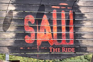
Saw – The Ride
Steel Euro Fighter roller coaster
Distance: Approx. 1224 meters
Latitude and longitude: 51.402623,-0.511905
Saw – The Ride is a steel roller coaster located at Thorpe Park in Surrey, England. Manufactured by Gerstlauer, the Euro-Fighter model opened to the public on 14 March 2009 as the steepest freefall roller coaster in the world, with a drop angle of 100 degrees. It is themed to the Saw franchise, featuring an enclosed dark section and queue theming which makes numerous references to the film series and props used in the films and other Saw media.
Tara, Chertsey
Residential in Chertsey, Surrey
Distance: Approx. 776 meters
Latitude and longitude: 51.39445,-0.520167
Tara was a house on St Anns Hill, Chertsey, Surrey owned by The Who's drummer Keith Moon in the 1970s, but was demolished and replaced by a new home in 1990. The press party for the release of the Who's Next album was held at Tara.

Old Town Hall, Chertsey
Municipal building in Chertsey, Surrey, England
Distance: Approx. 501 meters
Latitude and longitude: 51.392,-0.5027
The Old Town Hall is a municipal building in London Road, Chertsey, Surrey, England. The structure, which was the main civic venue for the town, is a Grade II listed building.

Hyperia (roller coaster)
Roller coaster at Thorpe Park, England
Distance: Approx. 1121 meters
Latitude and longitude: 51.401661,-0.512266
Hyperia is a steel roller coaster located at Thorpe Park in Chertsey, Surrey, England. Manufactured by Mack Rides, the hypercoaster opened as the tallest and fastest roller coaster in the UK on 24 May 2024, with a height of 236 feet (72 m) and a maximum speed that reportedly exceeds 80 mph (130 km/h). It also features two inversions.
Weather in this IP's area
broken clouds
15 Celsius
15 Celsius
14 Celsius
16 Celsius
1018 hPa
84 %
1018 hPa
1017 hPa
10000 meters
3.09 m/s
30 degree
75 %
06:47:02
19:03:04