Country:
Region:
City:
Latitude and Longitude:
Time Zone:
Postal Code:
IP information under different IP Channel
ip-api
Country
Region
City
ASN
Time Zone
ISP
Blacklist
Proxy
Latitude
Longitude
Postal
Route
Luminati
Country
ASN
Time Zone
Europe/Amsterdam
ISP
Booking.com BV
Latitude
Longitude
Postal
IPinfo
Country
Region
City
ASN
Time Zone
ISP
Blacklist
Proxy
Latitude
Longitude
Postal
Route
db-ip
Country
Region
City
ASN
Time Zone
ISP
Blacklist
Proxy
Latitude
Longitude
Postal
Route
ipdata
Country
Region
City
ASN
Time Zone
ISP
Blacklist
Proxy
Latitude
Longitude
Postal
Route
Popular places and events near this IP address

Zuyderzée
Distance: Approx. 167 meters
Latitude and longitude: 52.3667,4.9
Zuyderzée (French: [zɥi.dɛʁ.ze], "Southern Sea", Dutch: Zuyderzee) was a department of the First French Empire in the present-day Netherlands. It was named after the Zuiderzee sea inlet. It was formed in 1810, when the Kingdom of Holland was annexed by France.

Blauwbrug
Historic bridge in Amsterdam
Distance: Approx. 184 meters
Latitude and longitude: 52.3663,4.9009
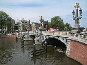
The Blauwbrug (English: Blue bridge) is a historic bridge in Amsterdam, Netherlands over the river Amstel. It connects the Rembrandtplein area with the Waterlooplein area, and lies south to the Stopera. The bridge owes its name to a wooden "blue bridge" that was there from around 1600 but no longer exists and which was painted the characteristic blue of the Dutch flag.
Rembrandtplein
Square in Amsterdam, Netherlands
Distance: Approx. 144 meters
Latitude and longitude: 52.36611111,4.89666667
Rembrandtplein (English: Rembrandt Square) is a major square in central Amsterdam, Netherlands, named after Rembrandt van Rijn who owned a house nearby from 1639 to 1656.

De Kleine Komedie
Theatre in Amsterdam, Netherlands
Distance: Approx. 219 meters
Latitude and longitude: 52.36680556,4.89611111
De Kleine Komedie is today the oldest theatre in Amsterdam, dating from 1788. Situated on the Amstel near the Halvemaansteeg, the building offers a stage for both upcoming and established Dutch talents. The theatre has 503 seats.

Museum of Bags and Purses
Fashion Museum in Amsterdam, Netherlands
Distance: Approx. 128 meters
Latitude and longitude: 52.365938,4.896782
The Museum of Bags and Purses (Dutch: Tassenmuseum Amsterdam), was a museum devoted to the history of bags, purses, and their related accessories. Located in Amsterdam's historic central canal belt, the museum's collection included over 5,000 items dating back to the sixteenth-century. One of only three museums across the globe specialising in this field, it housed the world's largest collection of bags and purses.

Amstelhof
Distance: Approx. 276 meters
Latitude and longitude: 52.365,4.9025
The Amstelhof (English: Amstel court), was a retirement home that is the H'ART Museum. It was built near the Amstel river in 1682 by the diaconate of the Dutch Reformed Church after having received an inheritance of the rich merchant Barent Helleman. He died on 18 October 1680 and left approximately 90,000 guilders to the church.

Amsterdam metropolitan area
Metropolitan region in Netherlands
Distance: Approx. 164 meters
Latitude and longitude: 52.366667,4.9
The Metropolitan Region Amsterdam (Dutch: Metropoolregio Amsterdam) is the city region around the city of Amsterdam, the capital of the Netherlands. It lies in the Noordvleugel (English: "North Wing") of the larger polycentric Randstad metropolitan area and encompasses the city of Amsterdam, the provinces of North Holland and Flevoland, as well as 36 further municipalities within the two provinces, with a total population of over 2.5 million inhabitants. The administrative responsibility for the Metropolitan Region Amsterdam lies with the Metropolitan Region Amsterdam Central Administration (BKG).
Ajax Experience
Sports Museum in entry at Utrechtsestraat , DA Amsterdam
Distance: Approx. 83 meters
Latitude and longitude: 52.3661,4.8978
The Ajax Experience was a museum dedicated to AFC Ajax' club history in Amsterdam in the Netherlands. The museum, located at the Rembrandtplein, was opened on 24 September 2011 and closed within two years after a 9 million euro loss.
Spectrum (Amsterdam)
Restaurant in Amsterdam, Netherlands
Distance: Approx. 166 meters
Latitude and longitude: 52.36462222,4.89655833
Restaurant Spectrum (formerly Librije's Zusje) is a restaurant located in the Waldorf Astoria hotel in Amsterdam, Netherlands. It is a fine dining restaurant that is awarded two Michelin star since 2015. Head chef of Spectrum is Sidney Schutte.

Reguliersgracht
Canal in Amsterdam
Distance: Approx. 257 meters
Latitude and longitude: 52.3639,4.8958
Reguliersgracht is a canal in Amsterdam, Netherlands. Established in 1658, it is located in the Grachtengordel, in the Centrum borough. During World War II the "nerve center" of the illegal paper Het Parool was housed there, in a house (number 111) occupied by Simon Carmiggelt, Max Nord, Wim van Norden and their families.
Waldorf Astoria Amsterdam
Distance: Approx. 137 meters
Latitude and longitude: 52.364738,4.896956
Waldorf Astoria Amsterdam is a five-star luxury hotel in Amsterdam, part of Hilton Worldwide. Waldorf Astoria Amsterdam was opened on May 1, 2014. It is the 25th hotel of the Waldorf Astoria Hotels & Resorts.

Nieuwe Achtergracht
Canal in Amsterdam
Distance: Approx. 257 meters
Latitude and longitude: 52.3639,4.8958
The Nieuwe Achtergracht is a canal in Amsterdam in the east of the Grachtengordel (canal belt) in the Amsterdam-Centrum district. It runs parallel to the Nieuwe Prinsengracht and connects the Onbekendegracht with the Plantage Muidergracht. The canal is crossed by Weesperstraat (at the Weesperplein) and Roetersstraat.
Weather in this IP's area
mist
9 Celsius
6 Celsius
8 Celsius
11 Celsius
1014 hPa
90 %
1014 hPa
1013 hPa
3500 meters
6.17 m/s
210 degree
75 %
08:04:02
16:46:40

