Country:
 France
Region:
City:
Latitude and Longitude:
Time Zone:
Postal Code:
IP information under different IP Channel
ip-api
Country
Region
City
ASN
Time Zone
ISP
Blacklist
Proxy
Latitude
Longitude
Postal
Route
IPinfo
Country
Region
City
ASN
Time Zone
ISP
Blacklist
Proxy
Latitude
Longitude
Postal
Route
MaxMind
Country
Region
City
ASN
Time Zone
ISP
Blacklist
Proxy
Latitude
Longitude
Postal
Route
Luminati
Country
FRASN
Time Zone
Europe/Paris
ISP
Alsatis SAS
Latitude
Longitude
Postal
db-ip
Country
Region
City
ASN
Time Zone
ISP
Blacklist
Proxy
Latitude
Longitude
Postal
Route
ipdata
Country
Region
City
ASN
Time Zone
ISP
Blacklist
Proxy
Latitude
Longitude
Postal
Route
Popular places and events near this IP address

Vendée Globe
Yacht race
Distance: Approx. 302 meters
Latitude and longitude: 46.4951,-1.7886
The Vendée Globe is a single-handed (solo) non-stop round the world yacht race. The race was founded by Philippe Jeantot in 1989, and since 1992 has taken place every four years. It is named after the Département of Vendée, in France, where the race starts and ends.
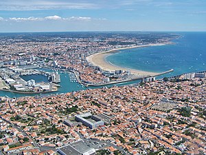
Les Sables-d'Olonne
Subprefecture and commune in Pays de la Loire, France
Distance: Approx. 381 meters
Latitude and longitude: 46.4972,-1.7833
Les Sables-d'Olonne (French pronunciation: [le sabl dɔlɔn] ; French meaning: "The Sands of Olonne"; Poitevin: Lés Sablles d'Oloune) is a seaside resort and port on the Atlantic coast of western France. A subprefecture of the department of Vendée, Pays de la Loire, it has the administrative level of commune. On 1 January 2019, the municipalities of Olonne-sur-Mer, Château-d'Olonne and Les Sables-d'Olonne merged, retaining the latter name.

Arrondissement of Les Sables-d'Olonne
Arrondissement in Pays de la Loire, France
Distance: Approx. 937 meters
Latitude and longitude: 46.5,-1.8
The arrondissement of Les Sables-d'Olonne is an arrondissement of France in the Vendée department in the Pays de la Loire region. It has 71 communes. Its population is 235,082 (2016), and its area is 1,914.7 km2 (739.3 sq mi).

Château-d'Olonne
Part of Les Sables-d'Olonne in Pays de la Loire, France
Distance: Approx. 4072 meters
Latitude and longitude: 46.505,-1.7361
Château-d'Olonne (French pronunciation: [ʃɑto dɔlɔn]) is a former commune of the Vendée department in the Pays de la Loire region of Western France. On 1 January 2019, it was merged into the commune of Les Sables-d'Olonne.
Côte de Lumière
Distance: Approx. 4334 meters
Latitude and longitude: 46.53,-1.82
The Côte de Lumière (French pronunciation: [kot də lymjɛʁ]; English: Coast of Light) refers to the seaside resorts located along the coast of the Vendée, France.

L'Armendèche Lighthouse
Lighthouse in Vendée, France
Distance: Approx. 1553 meters
Latitude and longitude: 46.48972222,-1.80472222
L'Armendèche Lighthouse is a French lighthouse located along the coast of the Vendée department; it is located in La Chaume, a district of Les Sables-d'Olonne. It was the last major lighthouse to be constructed on French territory, and takes its name from that of a place just down the coast. The lighthouse was constructed in 1968 to a design by local architect Maurice Durand; unlike his other lighthouses, it was not meant to replace a tower which had been destroyed during World War II, but was instead built new as a landfall light.

Battle of Les Sables-d'Olonne
Minor English and France maritime conflict
Distance: Approx. 1238 meters
Latitude and longitude: 46.4872,-1.7833
The Battle of Les Sables-d'Olonne was a minor naval battle fought on 23 February 1809 off the town of Les Sables-d'Olonne on the Biscay Coast of France between a French Navy squadron of three frigates and a larger British squadron of ships of the line. The French squadron had sailed from the port of Lorient on 23 February in an effort to link up with a fleet from Brest under Jean-Baptiste Willaumez, but missed the rendezvous and was pursued by a British blockade squadron under Rear-Admiral Robert Stopford. The French commander, Commodore Pierre Roch Jurien, anchored his squadron under the batteries which protected the town of Les Sables-d'Olonne in the hope of dissuading an attack.

Villa Blanche
Historic townhouse in Vendée, France
Distance: Approx. 436 meters
Latitude and longitude: 46.49492,-1.78435
The Villa Blanche is a historic townhouse in Les Sables-d'Olonne, Vendée, France. It was built in 1913, and designed by architect Maurice Durand. It was a tearoom until 1914, when it was used by an estate agent named Fraud.

Villa Mirasol (Les Sables d'Olonne)
Residential building in Les Sables-d'Olonne, France
Distance: Approx. 443 meters
Latitude and longitude: 46.49491,-1.78422
For the village in Argentina, see Villa Mirasol. The Villa Mirasol is a historic residential building in Les Sables d'Olonne, Vendée, France.
Canton of Les Sables-d'Olonne
Distance: Approx. 674 meters
Latitude and longitude: 46.5,-1.78
The canton of Les Sables-d'Olonne is an administrative division of the Vendée department, western France. Its borders were modified at the French canton reorganisation which came into effect in March 2015. Its seat is in Les Sables-d'Olonne.

Les Sables-d'Olonne station
Railway station in Les Sables-d'Olonne, France
Distance: Approx. 564 meters
Latitude and longitude: 46.49972222,-1.78138889
Les Sables-d'Olonne station is a railway station serving the town Les Sables-d'Olonne, Vendée department, western France. The station is served by high speed trains to Paris and by regional trains towards La Roche-sur-Yon and Nantes.
Vendée Arctique
Solo Oceanic Yacht Race
Distance: Approx. 302 meters
Latitude and longitude: 46.4951,-1.7886
The Vendée Arctique is a single-handed (solo) yacht race, from France to the Arctic Circle and back.
Weather in this IP's area
scattered clouds
12 Celsius
11 Celsius
12 Celsius
12 Celsius
1017 hPa
89 %
1017 hPa
1017 hPa
10000 meters
5.52 m/s
8.39 m/s
327 degree
26 %
08:28:56
19:15:13