37.0.70.53 - IP Lookup: Free IP Address Lookup, Postal Code Lookup, IP Location Lookup, IP ASN, Public IP
Country:
Region:
City:
Location:
Time Zone:
Postal Code:
IP information under different IP Channel
ip-api
Country
Region
City
ASN
Time Zone
ISP
Blacklist
Proxy
Latitude
Longitude
Postal
Route
Luminati
Country
Region
16
City
podgorica
ASN
Time Zone
Europe/Podgorica
ISP
Serbia BroadBand-Srpske Kablovske mreze d.o.o.
Latitude
Longitude
Postal
IPinfo
Country
Region
City
ASN
Time Zone
ISP
Blacklist
Proxy
Latitude
Longitude
Postal
Route
IP2Location
37.0.70.53Country
Region
kotor
City
kotor
Time Zone
Europe/Podgorica
ISP
Language
User-Agent
Latitude
Longitude
Postal
db-ip
Country
Region
City
ASN
Time Zone
ISP
Blacklist
Proxy
Latitude
Longitude
Postal
Route
ipdata
Country
Region
City
ASN
Time Zone
ISP
Blacklist
Proxy
Latitude
Longitude
Postal
Route
Popular places and events near this IP address

Kotor
City on Montenegro coast
Distance: Approx. 1046 meters
Latitude and longitude: 42.43,18.77
Kotor (Montenegrin Cyrillic: Котор, pronounced [kɔ̌tɔr]), historically known as Cattaro (from Italian: pronounced [ˈkattaro]), is a town in Coastal region of Montenegro. It is located in a secluded part of the Bay of Kotor. The city has a population of 13,347 and is the administrative center of Kotor Municipality.

Roman Catholic Diocese of Kotor
Latin Catholic territory in Montenegro
Distance: Approx. 1046 meters
Latitude and longitude: 42.43,18.77
The Diocese of Kotor (Montenegrin: Которска шкофија, romanized: Kotorska škofija; Croatian: Kotorska biskupija; Latin: Dioecesis Catharensis) is a Latin Church ecclesiastical jurisdiction or diocese of the Catholic Church in the Bay of Kotor and Municipality of Budva area in Montenegro. It is centered in the city of Kotor (Cattaro). It was erected as a diocese in the 10th century.

Kotor Cathedral
Church in Montenegro
Distance: Approx. 485 meters
Latitude and longitude: 42.4241,18.7719
The Cathedral of Saint Tryphon (Serbo-Croatian: Katedrala Svetog Tripuna/Катедрала Светог Трипуна) in Kotor, Montenegro is one of two Roman Catholic cathedrals in Montenegro. It is the seat of the Roman Catholic Diocese of Kotor, which covers the entire Bay of Kotor and Municipality of Budva.
Stadion pod Vrmcem
Football stadium in Kotor, Montenegro
Distance: Approx. 269 meters
Latitude and longitude: 42.420295,18.764979
Stadion Pod Vrmcem is a football stadium in Kotor, Montenegro. It is used mostly for football matches and is the home ground of FK Bokelj. The stadium holds 1,000 people.
Fortifications of Kotor
UNESCO World Heritage Site
Distance: Approx. 447 meters
Latitude and longitude: 42.42361111,18.77194444
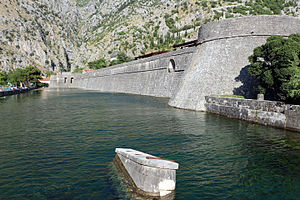
The fortifications of Kotor (Italian: Cattaro) are an integrated historical fortification system that protected the medieval town of Kotor containing ramparts, towers, citadels, gates, bastions, forts, cisterns, a castle, and ancillary buildings and structures. They incorporate military architecture of Illyria, the Byzantine Empire, Venice, and Austria. Together with the old town and its natural surroundings the fortifications were inscribed in the list of World Heritage Sites in 1979 labelled Natural and Culturo-Historical Region of Kotor and represent the only such site of cultural significance in Montenegro.

Škaljari
Town in Coastal, Montenegro
Distance: Approx. 276 meters
Latitude and longitude: 42.41861111,18.76638889
Škaljari is a small town in the municipality of Kotor, Montenegro. It is located just south of Kotor town.

Church of Our Lady of Remedy
Church
Distance: Approx. 1046 meters
Latitude and longitude: 42.43,18.77
The Church of Our Lady of Remedy (Serbian: Црква Госпе од Здравља, romanized: Crkva Gospe od Zdravlja) is a Roman Catholic church located in Kotor, Montenegro, belonging to the Roman Catholic Diocese of Kotor. The church is perched on the slope of St. John Mountain.

Trg od Oružja
Distance: Approx. 486 meters
Latitude and longitude: 42.424898,18.76984
Trg od Oružja (Cyrillic: Трг од оружја; meaning "Arms Square") is the main and the largest town square in Kotor, Montenegro. It hosts several stores, banks, cafés, bakeries and pastry shops, as well as many important cultural-historical monuments. Its name hails from Venetian times, when munitions were made and stored here.

Church of St. Nicholas, Kotor
Distance: Approx. 596 meters
Latitude and longitude: 42.4257,18.7708
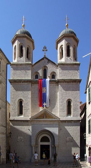
The Church of St. Nicholas (Serbian: Црква Светог Николе, romanized: Crkva Svetog Nikole) is a Serbian Orthodox church built from 1902 to 1909 in the city of Kotor. On that place the Orthodox Church existed from 1810 to the Christmas Eve in 1896, when it was burnt down in fire.

Muo
Village in Coastal, Montenegro
Distance: Approx. 1351 meters
Latitude and longitude: 42.430398,18.758311
Muo (Montenegrin: Муо) is a village in the municipality of Kotor, Montenegro.

Church of St. Luke (Kotor)
Distance: Approx. 587 meters
Latitude and longitude: 42.42548,18.77121
The Church of St. Luke in Boka Kotorska, Montenegro (Serbian Cyrillic: Црква Светог Луке у Котору) belongs to the Serbian Orthodox Church. The Byzantine and Gothic architecture was built in 1195 during Stefan Nemanja's reign.

Aquarium Boka
Zoo in Kotor, Montenegro
Distance: Approx. 1755 meters
Latitude and longitude: 42.43616667,18.76405556
Aquarium Boka (Adriatic Biodiversity Conservation Center ″Aquarium Boka″; Serbian: Centar za očuvanje morskog biodiverziteta ″Akvarijum Boka″) is the organizational unit of the Institute for Marine Biology of the University of Montenegro, founded in 2020, and it was officially opened to the public in June 2021. It is the first and only public aquarium in Montenegro, and in the first three months, the Aquarium was visited by more than 8,000 people. The aquarium is located in the Radoničić Palace, which was built at the beginning of the 19th century.
Weather in this IP's area
clear sky
12 Celsius
10 Celsius
8 Celsius
12 Celsius
1025 hPa
32 %
1025 hPa
1024 hPa
10000 meters
3.6 m/s
9.26 m/s
30 degree
