Country:
Region:
City:
Latitude and Longitude:
Time Zone:
Postal Code:
IP information under different IP Channel
ip-api
Country
Region
City
ASN
Time Zone
ISP
Blacklist
Proxy
Latitude
Longitude
Postal
Route
Luminati
Country
Region
36
City
myozaigun
ASN
Time Zone
Asia/Tokyo
ISP
STNet, Incorporated
Latitude
Longitude
Postal
IPinfo
Country
Region
City
ASN
Time Zone
ISP
Blacklist
Proxy
Latitude
Longitude
Postal
Route
db-ip
Country
Region
City
ASN
Time Zone
ISP
Blacklist
Proxy
Latitude
Longitude
Postal
Route
ipdata
Country
Region
City
ASN
Time Zone
ISP
Blacklist
Proxy
Latitude
Longitude
Postal
Route
Popular places and events near this IP address

Tokushima Prefecture
Prefecture of Japan
Distance: Approx. 8897 meters
Latitude and longitude: 34.03333333,134.43333333
Tokushima Prefecture (徳島県, Tokushima-ken) is a prefecture of Japan located on the island of Shikoku. Tokushima Prefecture has a population of 728,633 (1 October 2019) and has a geographic area of 4,146 km2 (1,601 sq mi). Tokushima Prefecture borders Kagawa Prefecture to the north, Ehime Prefecture to the west, and Kōchi Prefecture to the southwest.
Sanagōchi, Tokushima
Village in Shikoku, Japan
Distance: Approx. 9390 meters
Latitude and longitude: 34,134.45
Sanagōchi (佐那河内村, Sanagōchi-son) is a village located in Myōdō District, Tokushima Prefecture, Japan. As of 30 June 2022, the village had an estimated population of 1983 and a population density of 47 persons per km².The total area of the village is 42.28 square kilometres (16.32 sq mi). Sanagōchi is the only village remaining in Tokushima Prefecture.

Myōdō District, Tokushima
Distance: Approx. 9861 meters
Latitude and longitude: 33.9895,134.455
Myōdō (名東郡, Myōdō-gun) is a district located in Tokushima Prefecture, Japan. As of June 1, 2019, the district has an estimated population of 2,144 and a density of 49.8 inhabitants per square kilometer (129/sq mi). The total area is 42.28 km2 (16.32 sq mi).
Kamiyama, Tokushima
Town in Shikoku, Japan
Distance: Approx. 3154 meters
Latitude and longitude: 33.96722222,134.3505
Kamiyama (神山町, Kamiyama-chō) is a town in Myōzai District, Tokushima Prefecture, Japan. As of 30 June 2022, the town had an estimated population of 4,930 in 2404 households and a population density of 28 persons per km². The total area of the town is 173.305 square kilometres (66.913 sq mi).

Myōzai District, Tokushima
Distance: Approx. 1072 meters
Latitude and longitude: 33.996,134.36
Myōzai (名西郡, Myōzai-gun) is a district located in Tokushima Prefecture, Japan. As of June 1, 2019, the district has an estimated population of 29,786 and a population density of 147 inhabitants per square kilometre (380/sq mi). The total area is 202.15 km2 (78.05 sq mi).
Yoshinogawa, Tokushima
City in Shikoku, Japan
Distance: Approx. 7615 meters
Latitude and longitude: 34.06305556,134.36138889
Yoshinogawa (吉野川市, Yoshinogawa-shi) is a city located in Tokushima Prefecture, Japan. As of 30 June 2022, the city had an estimated population of 39,150 in 17958 households and a population density of 270 persons per km². The total area of the city is 144.14 square kilometres (55.65 sq mi).

Oezuka Station
Railway station in Yoshinogawa, Tokushima Prefecture, Japan
Distance: Approx. 9241 meters
Latitude and longitude: 34.0752,134.3764
Oezuka Station (麻植塚駅, Oezuka-eki) is a passenger railway station located in the city of Yoshinogawa, Tokushima Prefecture, Japan. It is operated by JR Shikoku and has the station number "B08".

Kamojima Station
Railway station in Yoshinogawa, Tokushima Prefecture, Japan
Distance: Approx. 8745 meters
Latitude and longitude: 34.0738,134.3561
Kamojima Station (鴨島駅, Kamojima-eki) is a passenger railway station located in the city of Yoshinogawa, Tokushima Prefecture, Japan. It is operated by JR Shikoku and has the station number "B09".

Nishi-Oe Station
Railway station in Yoshinogawa, Tokushima Prefecture, Japan
Distance: Approx. 8622 meters
Latitude and longitude: 34.0723,134.3363
Nishi-Oe Station (西麻植駅, Nishi-Oe-eki) is a passenger railway station located in the city of Yoshinogawa, Tokushima Prefecture, Japan. It is operated by JR Shikoku and has the station number "B10".
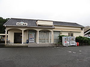
Awa-Kawashima Station
Railway station in Yoshinogawa, Tokushima Prefecture, Japan
Distance: Approx. 7814 meters
Latitude and longitude: 34.06185833,134.32077222
Awa-Kawashima Station (阿波川島駅, Awa-Kawashima-eki) is a passenger railway station located in the city of Yoshinogawa, Tokushima Prefecture, Japan. It is operated by JR Shikoku and has the station number "B11".

Gaku Station
Railway station in Yoshinogawa, Tokushima Prefecture, Japan
Distance: Approx. 8973 meters
Latitude and longitude: 34.0576,134.2864
Gaku Station (学駅, Gaku-eki) is a passenger railway station located in the city of Yoshinogawa, Tokushima Prefecture, Japan. It is operated by JR Shikoku and has the station number "B12".
Fujii-dera (Yoshinogawa)
Buddhist temple in Japan
Distance: Approx. 6251 meters
Latitude and longitude: 34.05165,134.34852
Fujii-dera (藤井寺) is a Zen Buddhist temple in Japan. It is the 11th site of the Shikoku Pilgrimage.
Weather in this IP's area
overcast clouds
10 Celsius
10 Celsius
10 Celsius
10 Celsius
1024 hPa
75 %
1024 hPa
978 hPa
10000 meters
1.03 m/s
1.25 m/s
238 degree
100 %
06:30:21
17:02:47


