36.253.136.62 - IP Lookup: Free IP Address Lookup, Postal Code Lookup, IP Location Lookup, IP ASN, Public IP
Country:
Region:
City:
Location:
Time Zone:
Postal Code:
ISP:
ASN:
language:
User-Agent:
Proxy IP:
Blacklist:
IP information under different IP Channel
ip-api
Country
Region
City
ASN
Time Zone
ISP
Blacklist
Proxy
Latitude
Longitude
Postal
Route
db-ip
Country
Region
City
ASN
Time Zone
ISP
Blacklist
Proxy
Latitude
Longitude
Postal
Route
IPinfo
Country
Region
City
ASN
Time Zone
ISP
Blacklist
Proxy
Latitude
Longitude
Postal
Route
IP2Location
36.253.136.62Country
Region
bagmati
City
kirtipur
Time Zone
Asia/Kathmandu
ISP
Language
User-Agent
Latitude
Longitude
Postal
ipdata
Country
Region
City
ASN
Time Zone
ISP
Blacklist
Proxy
Latitude
Longitude
Postal
Route
Popular places and events near this IP address
Tribhuvan University
Public university in Kathmandu, Nepal
Distance: Approx. 1102 meters
Latitude and longitude: 27.68184,85.28646
Tribhuvan University (TU; Nepali: त्रिभुवन विश्वविद्यालय) is a public university located in Kirtipur, Kathmandu, Nepal. Established in 1959, TU is the oldest and the largest university in Nepal. It offers 1,000 undergraduate and 500 postgraduate programs across a wide range of disciplines.

Kirtipur
Municipality in Bagmati, Nepal
Distance: Approx. 250 meters
Latitude and longitude: 27.67805556,85.27694444
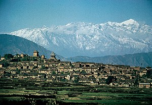
Kirtipur (Nepali: कीर्तिपुर; Nepal Bhasa: किपू Kipoo) is a Municipality and an ancient city of Nepal. The Newars are the natives of Kipoo (Kirtipur). It is located in the Kathmandu Valley 5 km south-west of the city of Kathmandu.

Chobhar
Village in Bagmati Zone, Nepal
Distance: Approx. 1663 meters
Latitude and longitude: 27.66666667,85.28333333
Chobhar (or Chovar, or Chobar) is a village in Kathmandu District in the Bagmati Zone of central Nepal and part of Kirtipur Municipality. At the time of the 1991 Nepal census it had a population of 5,627 living in 1,109 households. Chobhar is known for the nearby Chobhar Gorge where there are the Chobhar caves.
Naikap Naya Bhanjyang
Village of Chandragiri Municipality in No. 3, Nepal
Distance: Approx. 1248 meters
Latitude and longitude: 27.69,85.27
Naikap Naya Bhanjyang is a village and former Village Development Committee that is now part of Chandragiri Municipality in Kathmandu District in Province No. 3 of central Nepal. At the time of the 1991 Nepal census it had a population of 4,425.
Naikap Purano Bhanjyang
Village of Biratnagar Municipality in No. 3, Nepal
Distance: Approx. 2401 meters
Latitude and longitude: 27.7,85.26666667
Naikap Purano Bhanjyang is a former Village Development Committee that is now part of Chandragiri Municipality in Kathmandu District in Province No. 3 of central Nepal. At the time of the 1991 Nepal census it had a population of around 4000.
Satungal
Village of Chandragiri Municipality in No. 3, Nepal
Distance: Approx. 2514 meters
Latitude and longitude: 27.68,85.25
Satungal is a village and former Village Development Committee that is now a part of the Chandragiri Municipality in Kathmandu District in Province No. 3 in central Nepal. Satungal is also known as Satyapur ( In Newar Language).
Tinthana
Village of Chandragiri Municipality in No. 3, Nepal
Distance: Approx. 1248 meters
Latitude and longitude: 27.69,85.27
Tinthana is a village and former Village Development Committee that is now part of Chandragiri Municipality in Kathmandu District in Province No. 3 of central Nepal. At the time of the 2011 Nepal census it had a population of 9,726.

Adinath Lokeshwar
Distance: Approx. 2219 meters
Latitude and longitude: 27.6657,85.2913
Anandadi Lokeshwar Mandir is a temple sacred to Hindus and Buddhists in the village of Chobar, outside Kathmandu in Nepal. The temple is dedicated to Anandadi Lokeshwar, one of four principal Bodhisattvas honored as Lokeshwars in the Kathmandu Valley (or Adinath for Nepali speakers, who regard this deity as one of four Matsyendranaths). It was built in the 15th century, then rebuilt in 1640.

Tribhuvan University International Cricket Ground
Cricket ground in Kirtipur, Nepal
Distance: Approx. 1471 meters
Latitude and longitude: 27.67805556,85.29027778
Tribhuvan University International Cricket Ground, commonly known as TU Cricket Ground or simply TU Ground (Nepali: त्रिभुवन विश्वविद्यालय अन्तर्राष्ट्रिय क्रिकेट मैदान), is a prominent cricket stadium located in Kirtipur, near Kathmandu, Nepal. Situated within the premises of Tribhuvan University, it is the most renowned cricket venue in Nepal and serves as the headquarters for the Cricket Association of Nepal.
Panga, Kirtipur
Municipality in Bagmati Province, Nepal
Distance: Approx. 1663 meters
Latitude and longitude: 27.66666667,85.28333333
Panga (Nepali: पाँगा) is a typical Newari settlement and part of Kirtipur Municipality. Kirtipur is one of the five municipalities in the valley i.e.; Kirtipur Municipality, the others being Kathmandu, Lalitpur, Bhaktapur and Madhyapur Thimi. It is the small city surrounded by Chovar Hill, Kirtipur Hill and Machhegaon Hill.

Tribhuvan University Central Library
Public library in Nepal
Distance: Approx. 760 meters
Latitude and longitude: 27.6818,85.2829
Tribhuvan University Central Library (Nepali: त्रिभुवन विश्वविद्यालय केन्द्रीय पुस्तकालय, Tribhuvan Biswabidyalaya Kendriya Pustakalaya) is the largest public library in Nepal. It is operated by the Tribhuwan University and is located inside the Tribhuwan University campus at Kirtipur.

Bagh Bhairab Temple
Hindu temple in Kirtipur, Kathmandu
Distance: Approx. 108 meters
Latitude and longitude: 27.6794426,85.2764636
Bagh Bhairab Temple(Nepali: बाघ भैरव) is a historic Hindu temple dedicated to Bagh Bhairab, an incarnation of Shiva as a tiger. It is located in Kirtipur, Bagmati Province, Nepal and dates back to the 16th century. The residents of Kiritpur believe that Bagh Bhairab protects the town.
Weather in this IP's area
clear sky
8 Celsius
8 Celsius
8 Celsius
8 Celsius
1015 hPa
41 %
1015 hPa
851 hPa
10000 meters
0.65 m/s
1.12 m/s
186 degree