Country:
Region:
City:
Latitude and Longitude:
Time Zone:
Postal Code:
IP information under different IP Channel
ip-api
Country
Region
City
ASN
Time Zone
ISP
Blacklist
Proxy
Latitude
Longitude
Postal
Route
Luminati
Country
Region
mo
City
stlouis
ASN
Time Zone
America/Chicago
ISP
SPECTRUM-EVERSTREAM-CITYSC
Latitude
Longitude
Postal
IPinfo
Country
Region
City
ASN
Time Zone
ISP
Blacklist
Proxy
Latitude
Longitude
Postal
Route
db-ip
Country
Region
City
ASN
Time Zone
ISP
Blacklist
Proxy
Latitude
Longitude
Postal
Route
ipdata
Country
Region
City
ASN
Time Zone
ISP
Blacklist
Proxy
Latitude
Longitude
Postal
Route
Popular places and events near this IP address

University City, Missouri
City in Missouri, United States of America
Distance: Approx. 843 meters
Latitude and longitude: 38.66583333,-90.33166667
University City (colloquially, U. City) is an inner-ring suburb of the city of St. Louis in St. Louis County, in the U.S. state of Missouri.

St. Louis Walk of Fame
Award
Distance: Approx. 1884 meters
Latitude and longitude: 38.656,-90.3049
The St. Louis Walk of Fame honors notable people from St. Louis, Missouri, who made contributions to the culture of the United States.

University City–Big Bend station
Station in St. Louis MetroLink light rail system, Missouri, USA
Distance: Approx. 1739 meters
Latitude and longitude: 38.6517,-90.31524
University City–Big Bend station is a light rail station on the Blue Line of the St. Louis MetroLink system. This subway station is located beneath the intersection of Big Bend Boulevard and Forest Park Parkway and primarily serves passengers arriving on foot from nearby universities and surrounding neighborhoods.

University City High School (Missouri)
Comprehensive public high school in the United States
Distance: Approx. 651 meters
Latitude and longitude: 38.6651,-90.3293
University City High School (UCHS) is a public high school in University City, Missouri, United States, that is part of the School District of University City. As part of the University City Education District, the high school building was listed, along with nearby Jackson Park Elementary School and Hanley Junior High School, in the National Register of Historic Places on January 31, 1985.

Parkview, St. Louis
United States historic place
Distance: Approx. 1643 meters
Latitude and longitude: 38.655,-90.31
Parkview, also known as a "Saint Louis Urban Oasis," is a historic, private subdivision of St. Louis, Missouri. It is partly within the city limits of St.

Sutter-Meyer House
Historic house in Missouri, United States
Distance: Approx. 955 meters
Latitude and longitude: 38.66416667,-90.31138889
The Sutter-Meyer House is the oldest known residence in University City, Missouri, United States. It was built in 1873 and was added to the National Register of Historic Places in 1982. In 1986, it was designated a Landmark of University City by the Historic Preservation Commission.

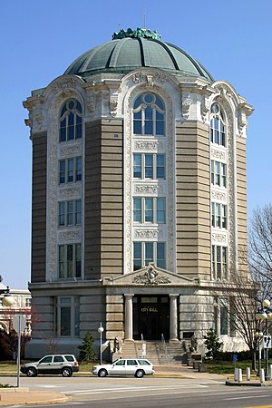
City Hall (University City, Missouri)
United States historic place
Distance: Approx. 1461 meters
Latitude and longitude: 38.6569,-90.3104
The City Hall of University City, Missouri, the seat of municipal government for University City, Missouri, was built in 1903 as the Woman's Magazine Building, the headquarters of a magazine publishing company, and became a city hall in 1930. The building is part of the University City Plaza, which was added to the National Register of Historic Places on March 7, 1975.

University City Public Library
Distance: Approx. 1555 meters
Latitude and longitude: 38.65666667,-90.30916667
The University City Public Library is a public library in University City, Missouri, near the Delmar Loop. Established in 1939, the library holds more than 150,000 books. It offers several activities and services for all ages.

Assumption Greek Orthodox Church
Historic church in Missouri, United States
Distance: Approx. 1471 meters
Latitude and longitude: 38.65611111,-90.31138889
Assumption Greek Orthodox Church is a historic church building at 6900 Delmar Boulevard in University City, Missouri. The building was added to the National Register of Historic Places in 1980.

Beverly Theater
United States historic place
Distance: Approx. 1460 meters
Latitude and longitude: 38.671944,-90.337222
The Beverly Theater is a former art-house theater in the Olive corridor commerce area of University City, MO.
Chesed Shel Emeth Cemetery
Jewish graveyard in St. Louis, Missouri
Distance: Approx. 1203 meters
Latitude and longitude: 38.671525,-90.33419
The Chesed Shel Emeth Cemetery is a Jewish graveyard located in University City, Missouri, an inner ring suburb of St. Louis.
University Township, St. Louis County, Missouri
Township in the US state of Missouri
Distance: Approx. 866 meters
Latitude and longitude: 38.67416667,-90.32138889
University Township is a township in St. Louis County, in the U.S. state of Missouri. Its population was 34,281 as of the 2010 census.
Weather in this IP's area
overcast clouds
16 Celsius
15 Celsius
15 Celsius
17 Celsius
1023 hPa
59 %
1023 hPa
1005 hPa
10000 meters
0.45 m/s
0.89 m/s
282 degree
94 %
06:36:20
16:53:53