Country:
Region:
City:
Latitude and Longitude:
Time Zone:
Postal Code:
IP information under different IP Channel
ip-api
Country
Region
City
ASN
Time Zone
ISP
Blacklist
Proxy
Latitude
Longitude
Postal
Route
Luminati
Country
Region
zac
City
guadalupe
ASN
Time Zone
America/Mexico_City
ISP
ATGS-MMD-AS
Latitude
Longitude
Postal
IPinfo
Country
Region
City
ASN
Time Zone
ISP
Blacklist
Proxy
Latitude
Longitude
Postal
Route
db-ip
Country
Region
City
ASN
Time Zone
ISP
Blacklist
Proxy
Latitude
Longitude
Postal
Route
ipdata
Country
Region
City
ASN
Time Zone
ISP
Blacklist
Proxy
Latitude
Longitude
Postal
Route
Popular places and events near this IP address

Callao
City in Peru
Distance: Approx. 1442 meters
Latitude and longitude: -12.05222222,-77.13916667
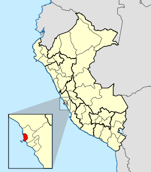
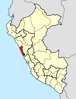
Callao (Spanish pronunciation: [kaˈʎao]) is a Peruvian seaside city and region on the Pacific Ocean in the Lima metropolitan area. Callao is Peru's chief seaport and home to its main airport, Jorge Chávez International Airport. Callao municipality consists of the whole Callao Region, which is also coterminous with the Province of Callao.

Bellavista District
District in Callao, Peru
Distance: Approx. 1322 meters
Latitude and longitude: -12.0624,-77.1286
Bellavista is a district of the Constitutional Province of Callao in Peru, and one of the seven districts that comprise the port city of Callao. The current mayor of the district is Daniel Malpartida.

Callao District
District in Callao, Peru
Distance: Approx. 1436 meters
Latitude and longitude: -12.0523,-77.1391
Callao is one of the seven districts of the Constitutional Province of Callao in the Callao Region, Peru. The Chillón River marks the district's northern border with Ventanilla. On the east, the Callao district is bordered by the Carmen de la Legua-Reynoso as well as the Lima Province's districts of San Martín de Porres and Lima.

Estadio Miguel Grau (Callao)
Distance: Approx. 1192 meters
Latitude and longitude: -12.05972,-77.11995
Estadio Miguel Grau is a multi-use stadium in the Bellavista District of Callao, Peru. The stadium is part of the Sport Village of Callao (Villa Deportiva del Callao) or Yahuar Huaca, which is owned by the Callao Regional Government since 2011. Its use is available to several association football teams in the region, including the Sport Boys, Universidad de San Martín and Academia Cantolao who play their home matches here for the Torneo Descentralizado.

Blockade of Callao
Military operation during Salpeter War
Distance: Approx. 803 meters
Latitude and longitude: -12.05,-77.13333333
The Blockade of Callao was a military operation that occurred during the War of the Pacific or the Salitre War and that consisted of the Chilean squadron preventing the entry of ships to the port of Callao and the neighboring coves between 10 April 1880 and 17 January 1881.

Roman Catholic Diocese of Callao
Roman Catholic diocese in Peru
Distance: Approx. 2104 meters
Latitude and longitude: -12.0333,-77.1333
The Roman Catholic Diocese of Callao (Latin: Callaën(sis)) is a diocese located in the city of Callao in the ecclesiastical province of Lima in Peru.

Roman Catholic Diocese of Chimbote
Roman Catholic diocese in Peru
Distance: Approx. 2104 meters
Latitude and longitude: -12.0333,-77.1333
The Roman Catholic Diocese of Chimbote (Latin: Cimbotien(sis)) is a diocese located in the city of Chimbote in the ecclesiastical province of Trujillo in Peru.

British Cemetery, Callao
Cemetery in Peru
Distance: Approx. 879 meters
Latitude and longitude: -12.057,-77.121
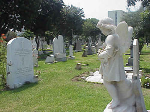
The British Cemetery of Callao Peru is a cemetery used exclusively for burials of members of the British community in Peru. It has since been used for other expatriate nationalities.
Colegio San José Maristas del Callao
Private school in Santa Marina Sur, Callao, Peru
Distance: Approx. 622 meters
Latitude and longitude: -12.05611111,-77.12777778
Colegio San José Maristas del Callao is a private Catholic primary and secondary school, located in Callao, in the Lima metropolitan area of Peru. The school is run by the Marist Brothers who began teaching in the area in 1909. In 2018 the secondary had 10 sections with 307 students.

First siege of Callao
Siege of the port of Callao in 1821 during the Peruvian War of Independence
Distance: Approx. 2102 meters
Latitude and longitude: -12.03333056,-77.13333056
The first siege of Callao was a prolonged military blockade of the Real Felipe Fortress (as well as other fortresses) in Callao by the Liberating Expedition of Peru under the command of General José de San Martín in July 1821 which culminated in the capitulation of Marshal José de La Mar in September of the same year, with him switching sides from the Royalist side to the Patriot side.

Second siege of Callao
Siege of the port of Callao from 1824 to 1826 during the Peruvian War of Independence
Distance: Approx. 2102 meters
Latitude and longitude: -12.03333056,-77.13333056
The second siege of Callao was the longest lasting siege that occurred on the Pacific coast during the Spanish American wars of independence. The siege was carried out by the combined Gran Colombian and Peruvian independence forces against the royalist soldiers defending the Real Felipe Fortress in the port of Callao, who refused to surrender, and refused to accept the capitulation of the Battle of Ayacucho. The siege took place from December 5, 1824 to January 23, 1826, when the royalist stronghold was defeated, ending the Spanish Empire's presence in South America.
Third siege of Callao
Siege of the port of Callao during the War of the Confederation
Distance: Approx. 2102 meters
Latitude and longitude: -12.03333056,-77.13333056
The third siege of Callao was a siege that took place in 1838 during the War of the Confederation between the United Restoration Army, supported by the Chilean army and the Peru–Bolivian Confederation. The confederates defeated the restorationist forces, who then retreated to Huacho due to the advance of the confederate army led by Andrés de Santa Cruz.
Weather in this IP's area
few clouds
21 Celsius
21 Celsius
21 Celsius
21 Celsius
1016 hPa
68 %
1016 hPa
1014 hPa
10000 meters
5.14 m/s
180 degree
20 %
05:33:42
18:11:22
