Country:
Region:
City:
Latitude and Longitude:
Time Zone:
Postal Code:
IP information under different IP Channel
ip-api
Country
Region
City
ASN
Time Zone
ISP
Blacklist
Proxy
Latitude
Longitude
Postal
Route
Luminati
Country
Region
zac
City
guadalupe
ASN
Time Zone
America/Mexico_City
ISP
ATGS-MMD-AS
Latitude
Longitude
Postal
IPinfo
Country
Region
City
ASN
Time Zone
ISP
Blacklist
Proxy
Latitude
Longitude
Postal
Route
db-ip
Country
Region
City
ASN
Time Zone
ISP
Blacklist
Proxy
Latitude
Longitude
Postal
Route
ipdata
Country
Region
City
ASN
Time Zone
ISP
Blacklist
Proxy
Latitude
Longitude
Postal
Route
Popular places and events near this IP address
Balboa, Panama
Place in Panama
Distance: Approx. 3943 meters
Latitude and longitude: 8.95,-79.56666667
Balboa is a district of Panama City, located at the Pacific entrance to the Panama Canal. It was the former capital of the Panama Canal Zone under American administration.

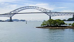
Bridge of the Americas
Road bridge in Panama spanning the Pacific entrance to the Panama Canal
Distance: Approx. 3632 meters
Latitude and longitude: 8.94305556,-79.565
The Bridge of the Americas (Spanish: Puente de las Américas; originally known as the Thatcher Ferry Bridge) is a road bridge in Panama which spans the Pacific entrance to the Panama Canal. Designed by Sverdrup & Parcel, it was completed in 1962 at a cost of US$20 million, connecting the north and south American land masses (hence its name), connecting the American Continent. Two other bridges cross the canal: the Atlantic Bridge at the Gatun locks and the Centennial Bridge.

Latin American Parliament
Organization of countries of Latin America and the Caribbean
Distance: Approx. 4841 meters
Latitude and longitude: 8.944185,-79.553225
The Latin American Parliament (Parlatino) is a regional, permanent organization composed by the countries of Latin America and the Caribbean. It is a consultative assembly similar to the early European Parliament. Currently the institution is being considered to become the legislative organ of the Community of Latin American and Caribbean States.

Howard Air Force Base
Airport
Distance: Approx. 1433 meters
Latitude and longitude: 8.915,-79.59944444
Howard Air Force Base (IATA: BLB, ICAO: MPHO) is a former United States Air Force base located in Panama. It discontinued military operations on 1 November 1999 as a result of the Torrijos-Carter Treaties, which specified that US military facilities in the former Panama Canal Zone be closed and the facilities be turned over to the Panamanian government. The airport is located 6 miles (9.7 km) southwest of Balboa, at the southern (Pacific) end of the Panama Canal.
Fort Amador
Historic United States Army bases
Distance: Approx. 5182 meters
Latitude and longitude: 8.93805556,-79.54777778
Fort Amador (Spanish: Fuerte Amador) and Fort Grant were former United States Army bases built to protect the Pacific (southern) end of the Panama Canal at Panama Bay. Amador was the primary on-land site, lying below the Bridge of the Americas. Grant consisted of a series of islands lying just offshore, some connected to Amador via a causeway.
Estadio Municipal de Balboa
Distance: Approx. 5135 meters
Latitude and longitude: 8.95777778,-79.55916667
Estadio Municipal de Balboa is a multi-purpose stadium in Balboa, Panama. It is currently used mostly for football matches and is the home stadium of Municipal Chorrillo. The stadium holds 2,000 people.
International Maritime University of Panama
Distance: Approx. 4019 meters
Latitude and longitude: 8.94546,-79.56236
The International Maritime University of Panama (in Spanish: Universidad Marítima Internacional de Panamá, UMIP) is a maritime college in Panama City, Panama. It trains cadets to become merchant marine ships' officers. It is located in the Albrook area of Panama City, on the site of the former Albrook Air Force Base.
Fort Kobbe
Distance: Approx. 3140 meters
Latitude and longitude: 8.9,-79.58333333
Fort Kobbe was an Army fort renamed from Fort Bruja on 15 April 1932 to honor Major General William A. Kobbe. At the time it was located adjacent to Howard Air Force Base in the Panama Canal Zone. In the 1930s it was primarily a United States Army Coast Artillery Corps post.
Panama Pacifico
Place in West Panamá Province, Panama
Distance: Approx. 1433 meters
Latitude and longitude: 8.915,-79.59944444
Panama Pacifico is a mixed-use real estate development in Veracruz, Arraiján District, Panama, located on the site of the former Howard Air Force Base (now Panamá Pacífico International Airport). Panama Pacifico is located 15 minutes from downtown Panama City, 35 minutes from Tocumen International Airport, and adjacent to the Pan-American Highway that connects the Americas. London & Regional Properties and Colombian banker Jaime Gilinski formed a consortium to develop the Panama Pacifico business and residential community.
PSA Panama International Terminal
Former United States military installation, now Panama Canal Port
Distance: Approx. 3610 meters
Latitude and longitude: 8.956,-79.58
PSA Panama International Terminal is a port built by PSA International on the site of the former United States Navy Rodman Naval Base located southwest of Panama City at the entrance to the Panama Canal from the Pacific Ocean.
Veracruz, Panama
Corregimiento in Panamá Oeste, Panama
Distance: Approx. 5145 meters
Latitude and longitude: 8.8911,-79.6236
Veracruz is a corregimiento in Arraiján District, Panamá Oeste Province, Panama with a population of 18,589 as of 2010. Its population as of 1990 was 8,224; its population as of 2000 was 16,748.

Panamá Pacífico International Airport
Commercial airport serving Panama City, Panama
Distance: Approx. 1433 meters
Latitude and longitude: 8.915,-79.59944444
Panamá Pacífico International Airport (IATA: BLB, ICAO: MPPA) is a commercial airport in Panama. It is located on the site of the former Howard Air Force Base, a United States Air Force base that was within the Panama Canal Zone. Panama City can be reached by crossing the nearby Bridge of the Americas.
Weather in this IP's area
overcast clouds
26 Celsius
26 Celsius
24 Celsius
26 Celsius
1010 hPa
81 %
1010 hPa
1009 hPa
10000 meters
2.57 m/s
180 degree
100 %
06:11:26
17:54:34