Country:
 Brazil
Region:
City:
Latitude and Longitude:
Time Zone:
Postal Code:
IP information under different IP Channel
ip-api
Country
Region
City
ASN
Time Zone
ISP
Blacklist
Proxy
Latitude
Longitude
Postal
Route
IPinfo
Country
Region
City
ASN
Time Zone
ISP
Blacklist
Proxy
Latitude
Longitude
Postal
Route
MaxMind
Country
Region
City
ASN
Time Zone
ISP
Blacklist
Proxy
Latitude
Longitude
Postal
Route
Luminati
Country
 MX
MXRegion
cmx
City
mexicocity
ASN
Time Zone
America/Mexico_City
ISP
ATGS-MMD-AS
Latitude
Longitude
Postal
db-ip
Country
Region
City
ASN
Time Zone
ISP
Blacklist
Proxy
Latitude
Longitude
Postal
Route
ipdata
Country
Region
City
ASN
Time Zone
ISP
Blacklist
Proxy
Latitude
Longitude
Postal
Route
Popular places and events near this IP address

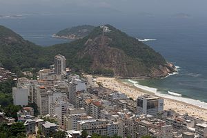
Copacabana, Rio de Janeiro
Neighborhood of Rio de Janeiro, Brazil
Distance: Approx. 1173 meters
Latitude and longitude: -22.96694444,-43.18055556
Copacabana ( KOH-pə-kə-BAN-ə, US also -BAH-nə, Portuguese: [ˌkɔpakaˈbɐnɐ]) is a bairro (neighbourhood) located in the South Zone of the city of Rio de Janeiro, Brazil. It is most prominently known for its 4 km (2.5 miles) balneario beach, which is one of the most famous in the world.
Botafogo
Neighborhood in Rio de Janeiro, Rio de Janeiro, Brazil
Distance: Approx. 1144 meters
Latitude and longitude: -22.95,-43.18416667
Botafogo (local/standard Portuguese pronunciation: [bɔtaˈfoɡu] alternative Brazilian Portuguese pronunciation: [botɐˈfoɡu]) is a beachfront neighborhood (bairro) in Rio de Janeiro, Brazil. It is a mostly upper middle class and small commerce community, and is located between the hills of Mundo Novo, Dona Marta (which separates it from Laranjeiras) and São João (which separates it from Copacabana). The word Botafogo also refers to a Latin American ballroom dance move that originated in this area.

Centro Brasileiro de Pesquisas Físicas
Physics research center in Rio de Janeiro, Brazil
Distance: Approx. 440 meters
Latitude and longitude: -22.95398611,-43.17370833
The Brazilian Center for Research in Physics (Portuguese: Centro Brasileiro de Pesquisas Físicas, CBPF) is a physics research center in the Urca neighborhood of Rio de Janeiro sponsored by the Brazilian National Council for Scientific and Technological Development (CNPq), linked to the Ministry of Science and Technology. CBPF was founded in 1949 from a joint effort of Cesar Lattes, José Leite Lopes, and Jayme Tiomno. Throughout its existence, CBPF became an internationally renowned research institution, organizing several international meetings and hosting many renowned physicists, like Richard Feynman and J. Robert Oppenheimer.

Instituto Benjamin Constant
Brazilian institute for the education of the visually impaired
Distance: Approx. 573 meters
Latitude and longitude: -22.953597,-43.172208
Instituto Benjamin Constant (IBC) is a part of Brazil's Ministry of Education, and is charged with promoting educational opportunities for the visually impaired. It is located in the neighborhood of Urca in Rio de Janeiro. IBC was created by imperial decree in 1854, and is named after the Brazilian soldier and intellectual Benjamin Constant.
Leme, Rio de Janeiro
Neighborhood in Rio de Janeiro, Rio de Janeiro, Brazil
Distance: Approx. 1126 meters
Latitude and longitude: -22.96222222,-43.16666667
Leme (Portuguese pronunciation: [ˈlẽmi], rudder) is an upper-middle-class neighborhood in the South Zone of the City of Rio de Janeiro, Brazil, next to Copacabana, Urca and Botafogo. The neighborhood takes its name from a nearby rock formation whose shape resembles the rudder of a ship. In 1975 the hotel Le Méridien, one of the tallest buildings in the Leme beach, was built.

Copacabana Stadium
Former stadium in Rio de Janeiro, Brazil
Distance: Approx. 1010 meters
Latitude and longitude: -22.9659,-43.1734
Copacabana Stadium, also known as the Beach Volleyball Arena (Portuguese: Arena de Vôlei de Praia), was a temporary stadium located on Copacabana beach, in Rio de Janeiro, Brazil, that hosted the beach volleyball competition of the 2016 Summer Olympics. It was erected in 2016 specifically for the Olympic Games and was planned to be dismantled after the Games. It opened on 26 July 2016 and had a seating capacity of 12,000.
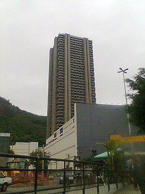
Rio Sul Center
Tallest building in Rio de Janeiro, Brazil
Distance: Approx. 21 meters
Latitude and longitude: -22.957314,-43.176033
The Rio Sul Center Tower, also known as Rio Sul Tower, is the fourteenth tallest building in Brazil and the tallest building in Rio de Janeiro at 164 metres (538 ft) and 50 floors, 48 above ground and 2 below. The structure contains 28 elevators It was completed in 1982. The building was designed by architects Ulysses Burlamaqui and Alexandre Chan in the Brutalist architectural style.
Hotel Atlantico Praia
Hotel in Copacabana, Rio de Janeiro, Brazil
Distance: Approx. 995 meters
Latitude and longitude: -22.96611111,-43.17694444
The Hotel Atlantico Praia, formerly the Ouro Verde Hotel, is a small hotel in Copacabana, Rio de Janeiro, Brazil. At one time the Ouro Verde was considered one of the world's best small hotels, and the restaurant had a high reputation. Over time it lost some of its lustre, but it has recently been renovated.
Teatro Villa-Lobos
Theater in Rio de Janeiro, Brazil
Distance: Approx. 423 meters
Latitude and longitude: -22.96083333,-43.175
The Villa-Lobos Theater (Portuguese: Teatro Villa-Lobos) is located in the Brazilian city of Rio de Janeiro. It opened in 1979 and belongs to the Anita Mantuano Foundation for the Arts of the State of Rio de Janeiro (Fundação Anita Mantuano de Artes do Estado do Rio de Janeiro - FUNARJ), which is linked to the Rio de Janeiro State Department of Culture (Secretaria Estadual de Cultura do Rio).
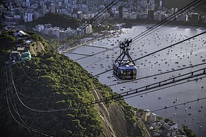
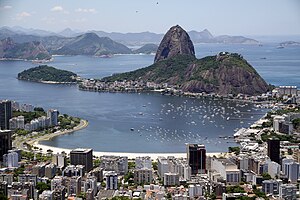
Sugarloaf Cable Car
Cableway system in Rio de Janeiro, Brazil
Distance: Approx. 966 meters
Latitude and longitude: -22.95555556,-43.16694444
The Sugarloaf Cable Car (Portuguese: Bondinho do Pão de Açúcar) is a cableway system in Rio de Janeiro, Brazil. The first part runs between Praia Vermelha and Morro da Urca (at 220 metres or 722 feet), from where the second rises to the summit of the 396-metre (1,299 ft) Sugarloaf Mountain. The cableway was envisioned by the engineer Augusto Ferreira Ramos in 1908 who sought support from well-known figures of Rio's high society to promote its construction.

Copacabana Palace
Hotel in Rio de Janeiro, Brazil
Distance: Approx. 1112 meters
Latitude and longitude: -22.966944,-43.178611
Copacabana Palace (currently branded as Copacabana Palace, A Belmond Hotel), is a hotel in the city of Rio de Janeiro, Brazil, facing Copacabana beach. Designed by French architect Joseph Gire, it was built in a style that follows the line and model of the great beach hotels of the nineteenth and early twentieth centuries, and opened on August 13, 1923. With over a century of existence, Belmond Copacabana Palace continues to be one of the most important hotel complexes in the city of Rio, and in Brazil, with two hundred and forty-three rooms (116 apartments and 127 suites), divided between the main and the annex building, in an area of twelve thousand square meters.

Earth Sciences Museum
Geological museum in Rio de Janeiro, Brazil
Distance: Approx. 700 meters
Latitude and longitude: -22.9536,-43.1706
The Earth Sciences Museum (Museu de Ciências da Terra) is a geological museum in Rio de Janeiro, Brazil. The building was part of the National Exposition of Brazil in 1908. Its collection includes minerals, fossils, and geological exhibits.
Weather in this IP's area
clear sky
31 Celsius
31 Celsius
30 Celsius
32 Celsius
1015 hPa
45 %
1015 hPa
1006 hPa
10000 meters
3.09 m/s
60 degree
05:43:55
17:48:09