Country:
 Brazil
Region:
City:
Latitude and Longitude:
Time Zone:
Postal Code:
IP information under different IP Channel
ip-api
Country
Region
City
ASN
Time Zone
ISP
Blacklist
Proxy
Latitude
Longitude
Postal
Route
IPinfo
Country
Region
City
ASN
Time Zone
ISP
Blacklist
Proxy
Latitude
Longitude
Postal
Route
MaxMind
Country
Region
City
ASN
Time Zone
ISP
Blacklist
Proxy
Latitude
Longitude
Postal
Route
Luminati
Country
 US
USASN
Time Zone
America/Chicago
ISP
ATGS-MMD-AS
Latitude
Longitude
Postal
db-ip
Country
Region
City
ASN
Time Zone
ISP
Blacklist
Proxy
Latitude
Longitude
Postal
Route
ipdata
Country
Region
City
ASN
Time Zone
ISP
Blacklist
Proxy
Latitude
Longitude
Postal
Route
Popular places and events near this IP address

Taubaté
Place in Southeastern Brazil
Distance: Approx. 2909 meters
Latitude and longitude: -23.025,-45.55555556
Taubaté is a medium-sized city in the State of São Paulo, in southeastern Brazil.

Joaquinzão
Soccer stadium in Brazil
Distance: Approx. 1661 meters
Latitude and longitude: -23.02784,-45.57054
Joaquinzão, also known as Estádio Joaquim de Morais Filho, is a multi-use stadium located in Taubaté, Brazil. It is used mostly for football matches and hosts the home matches of Esporte Clube Taubaté. The stadium has a maximum capacity of 9,600 people and was built in 1968.
Taubaté Prison
Brazilian prison
Distance: Approx. 3533 meters
Latitude and longitude: -23.013,-45.549
Taubaté Prison, an infamous correctional facility nestled in the city of Taubaté, São Paulo, Brazil, has gained notoriety due to its reputation for housing extremely violent offenders. This penitentiary has been plagued by a series of recurring prison riots and disturbances, further solidifying its status as a hotbed of unrest. Furthermore, it holds the distinction of being the birthplace of the gang Primeiro Comando da Capital.
Tremembé
City in Southeast, Brazil
Distance: Approx. 7854 meters
Latitude and longitude: -22.95972222,-45.54027778
Tremembé is a municipality in the state of São Paulo in Brazil. It is part of the Metropolitan Region of Vale do Paraíba e Litoral Norte. The population is 47,714 (2020 est.) in an area of 191.09 km².
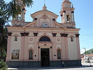
Basilica of the Good Lord Jesus, Tremembé
Church in Tremembé, Brazil
Distance: Approx. 8414 meters
Latitude and longitude: -22.9533,-45.5411
The Basilica of the Good Lord Jesus (Portuguese: Basílica do Senhor Bom Jesus) AKA Basilica of Tremembé is a Catholic church located in the city of Tremembé, São Paulo in the south of Brazil. The image of Good Lord Jesus of Tremembe is carved in wood and for the Catholic Church is a prominent religious artifact. The church of Bom Jesus de tremembé began as a chapel built by Manoel da Costa Cabral on his farm in the then town of Taubaté, in the place called Tremembé, in 1672.
Weather in this IP's area
clear sky
30 Celsius
30 Celsius
30 Celsius
31 Celsius
1012 hPa
42 %
1012 hPa
951 hPa
10000 meters
3.09 m/s
60 degree
05:53:33
17:57:47