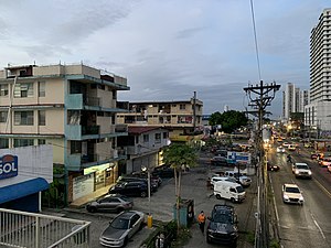
Country:
 Panama
Region:
City:
Latitude and Longitude:
Time Zone:
Postal Code:
IP information under different IP Channel
ip-api
Country
Region
City
ASN
Time Zone
ISP
Blacklist
Proxy
Latitude
Longitude
Postal
Route
IPinfo
Country
Region
City
ASN
Time Zone
ISP
Blacklist
Proxy
Latitude
Longitude
Postal
Route
MaxMind
Country
Region
City
ASN
Time Zone
ISP
Blacklist
Proxy
Latitude
Longitude
Postal
Route
Luminati
Country
 US
USASN
Time Zone
America/Chicago
ISP
ATGS-MMD-AS
Latitude
Longitude
Postal
db-ip
Country
Region
City
ASN
Time Zone
ISP
Blacklist
Proxy
Latitude
Longitude
Postal
Route
ipdata
Country
Region
City
ASN
Time Zone
ISP
Blacklist
Proxy
Latitude
Longitude
Postal
Route
Popular places and events near this IP address
Río Abajo
Corregimiento in Panamá, Panama
Distance: Approx. 3231 meters
Latitude and longitude: 9.01944444,-79.50138889
Río Abajo is a corregimiento within Panama City, in Panamá District, Panamá Province, Panama with a population of 26,607 as of 2010. Its population as of 1990 was 33,155; its population as of 2000 was 28,714. It is a West Indian neighborhood; the unique culture of this area of Panama stems mainly from the English Caribbean people who relocated to the area from Anglophone islands in the Antilles more than a century ago, namely Jamaica and Barbados.

Estadio Rommel Fernández
Panama City, Panama football stadium
Distance: Approx. 2806 meters
Latitude and longitude: 9.03583333,-79.46944444
The Estadio Olímpico Rommel Fernández Gutiérrez, named after the Panamanian football star Rommel Fernández (1966–1993), is a multi-purpose stadium in Panama City. It is used for different sports, but mainly football (soccer) games. It was inaugurated February 6, 1970, and was designed to accommodate the XI Central American and Caribbean Games in 1970.
Torre Planetarium
Residential in Costa del Este, Panama City
Distance: Approx. 763 meters
Latitude and longitude: 9.01027778,-79.46638889
The Torre Planetarium is a two-tower skyscraper in the design development stage located in Panama City. The taller tower, Tower 1, will be 343.4 metres (1,127 ft) tall and have 92 floors. The second and shorter Tower 2 will be 305.8 metres (1,003 ft) tall and contain 82 floors.

Panamá Viejo
Remains of the original Panama City, destroyed in 1671
Distance: Approx. 1502 meters
Latitude and longitude: 9.00555556,-79.48583333
Panamá Viejo (English: "Old Panama"), also known as Panamá la Vieja, is the remaining part of the original Panama City, the former capital of Panama, which was destroyed in 1671 by the Welsh privateer Henry Morgan. It is located in the suburbs of the current capital. Together with the historical district of Panamá, it has been a World Heritage Site since 1997.

Ocean Two
Residential skyscraper in the Costa del Este district of Panama City, Panama
Distance: Approx. 1005 meters
Latitude and longitude: 9.01055556,-79.46416667
Ocean Two (sometimes called O2) is a residential skyscraper in the Costa del Este district of Panama City, Panama. Construction of the 73-story, 245.7 m (806 ft) building began in 2006 and was completed in 2010. At the time of its completion, it became the tallest building in Panama and Latin America.

Roberto Durán Arena
Indoor sports arena in Panama
Distance: Approx. 2806 meters
Latitude and longitude: 9.03583333,-79.46944444
Roberto Durán Arena, originally known as Gimnasio Nuevo Panama, is an indoor sporting arena located in Panama City, Panama. The capacity of the arena is 8,417 spectators and opened in 1970. It hosts indoor sporting events such as basketball, boxing and volleyball.

Cancha de Entrenamiento Luis Tapia
Football stadium in Panama
Distance: Approx. 2567 meters
Latitude and longitude: 9.033817,-79.47056383
The Luis Ernesto "Cascarita" Tapia Court, or Mini Rommel as it was known, is an alternative court to Estadio Rommel Fernandez which provides training to the Panama national football team, but is also used by clubs of Panamanian Football League. It is named after the Panamanian footballer, famous in the 1960s and 1970s, called the "Central-American Pele". and is located in the Sports Complex of Ciudad Deportiva Irving Saladino.

Vitri Tower
Skyscraper in Costa del Este, Panama City
Distance: Approx. 1057 meters
Latitude and longitude: 9.0105,-79.4637
Torre Vitri or Vitri Tower is a 74-storey residential building located in Costa del Este, Panama City. Completed in 2012, the building is 260 metres (853 feet) tall and is the sixth-tallest building in Panama City and the 11th tallest building in Latin America.

Parque Lefevre
Corregimiento in Panamá, Panama
Distance: Approx. 1256 meters
Latitude and longitude: 9.0136,-79.4844
Parque Lefevre is a corregimiento within Panama City, in Panamá District, Panamá Province, Panama with a population of 36,997 as of 2010. Its population as of 1990 was 38,163; its population as of 2000 was 37,136.
Cincuentenario metro station
Panama metro station
Distance: Approx. 2953 meters
Latitude and longitude: 9.03027778,-79.49166667
Cincuentenario is a Panama Metro station on Line 2. It was opened on 25 April 2019 as part of the inaugural section of Line 2 between San Miguelito and Nuevo Tocumen. This is an elevated station built next to Avenida Domingo Díaz and Rotonda Roosevelt.
Villa Lucre metro station
Panama metro station
Distance: Approx. 3040 meters
Latitude and longitude: 9.03694444,-79.48166667
Villa Lucre is a Panama Metro station on Line 2. It was opened on 25 April 2019 as part of the inaugural section of Line 2 between San Miguelito and Nuevo Tocumen. This is an elevated station built above Avenida Domingo Díaz next to Boulevard Villa Lucre.
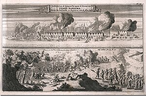
Henry Morgan's Panama expedition
Attack on Panama in 1670/1
Distance: Approx. 1502 meters
Latitude and longitude: 9.00555556,-79.48583333
Henry Morgan's Panama expedition also known as the Sack of Panama, was an expedition that took place between 16 December 1670 and 5 March 1671 during the later stage of the Anglo-Spanish War. English privateers and French pirates commanded by Buccaneer Henry Morgan launched an attack with an army of 1,400 men with the purpose of capturing the rich Spanish city of Panama off the Pacific coast. The expedition was set up in April 1670, and nine months later set off from Tortuga island off Hispaniola.
Weather in this IP's area
moderate rain
26 Celsius
27 Celsius
25 Celsius
29 Celsius
1009 hPa
92 %
1009 hPa
1008 hPa
9000 meters
4.12 m/s
110 degree
40 %
06:07:18
18:15:05