Country:
 Dominican Republic
Region:
City:
Latitude and Longitude:
Time Zone:
Postal Code:
IP information under different IP Channel
ip-api
Country
Region
City
ASN
Time Zone
ISP
Blacklist
Proxy
Latitude
Longitude
Postal
Route
IPinfo
Country
Region
City
ASN
Time Zone
ISP
Blacklist
Proxy
Latitude
Longitude
Postal
Route
MaxMind
Country
Region
City
ASN
Time Zone
ISP
Blacklist
Proxy
Latitude
Longitude
Postal
Route
Luminati
Country
 US
USASN
Time Zone
America/Chicago
ISP
ATGS-MMD-AS
Latitude
Longitude
Postal
db-ip
Country
Region
City
ASN
Time Zone
ISP
Blacklist
Proxy
Latitude
Longitude
Postal
Route
ipdata
Country
Region
City
ASN
Time Zone
ISP
Blacklist
Proxy
Latitude
Longitude
Postal
Route
Popular places and events near this IP address
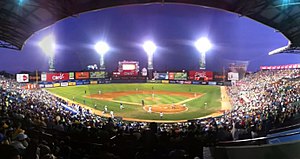
Estadio Quisqueya
Baseball stadium in Santo Domingo, Dominican Republic
Distance: Approx. 554 meters
Latitude and longitude: 18.48816111,-69.92641944
Estadio Quisqueya Juan Marichal (Spanish for Quisqueya Stadium Juan Marichal) is a baseball stadium in Santo Domingo, Dominican Republic. It is the only stadium in the Caribbean region to host two different baseball teams, Tigres del Licey (Licey Tigers) and Leones del Escogido (Chosen One Lions). Its field dimensions are 335 feet (102 m) at the foul poles, 383 feet (117 m) at the power alleys, and 411 feet (125 m) at center field.
Félix Sánchez Olympic Stadium
Distance: Approx. 1465 meters
Latitude and longitude: 18.480454,-69.918662
Félix Sánchez Olympic Stadium (Spanish: Estadio Olímpico Félix Sánchez) is open-air multi-purpose stadium in Santo Domingo, Dominican Republic. Opened in 1974 for the XII Central American & Caribbean Games and renovated 2003 Pan American Games is the largest stadium in the Dominican Republic used mostly for football and track and field and as a music venue. The stadium has a sporting events' capacity of 27,000 people, though it has seen crowds of 35,000.
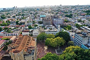
Ciudad Colonial (Santo Domingo)
Historic district in Dominican Republic
Distance: Approx. 1565 meters
Latitude and longitude: 18.48333333,-69.91666667
Ciudad Colonial (Spanish for "Colonial City") is the historic central neighborhood of the Dominican Republic's capital Santo Domingo. It is the oldest continuously inhabited European-established settlement in the Americas. The area has been declared a World Heritage Site by UNESCO. It is also known as Zona Colonial (Colonial Zone) or more colloquially as "La Zona" (The Zone).
Central Santo Domingo
Distance: Approx. 1010 meters
Latitude and longitude: 18.477167,-69.932871
Central Santo Domingo or better known as Polígono Central (English: Central Polygon) is a term used to group several neighborhoods located in central Santo Domingo, Distrito Nacional, Dominican Republic defined as the area delineated by John F Kennedy Avenue (also known as DR-1) on the north, on the west by Winston Churchill avenue, on the east by Maximo Gomez avenue, and on the south by 27 de Febrero avenue (also known as DR-3). The centric area forms the core of the city of Santo Domingo which includes the neighborhoods of Naco, Piantini, Paraíso, and Yolanda Morales. This central polygon, as the name implies, serves as the main economic and business center of the city.

Hospital General de la Plaza de la Salud
Hospital in Distrito Nacional, the Dominican Republic
Distance: Approx. 1034 meters
Latitude and longitude: 18.489055,-69.921915
Hospital General de la Plaza de la Salud (HGPS) is a non-profit entity with self-management in the selection and recruitment of staff and in the formulation and use of its budget. It is located on Avenida Ortega y Gasset Ensanche La Fe, Santo Domingo, Distrito Nacional of the Dominican Republic. The HGPS is technically and administratively managed by a board set up by Decree No.

Centro Olímpico Juan Pablo Duarte
Place in Dominican Republic
Distance: Approx. 1753 meters
Latitude and longitude: 18.478276,-69.916788
Centro Olímpico Juan Pablo Duarte (translation: Juan Pablo Duarte Olympic Center) is a multi-venued athletic complex in Santo Domingo, Dominican Republic. It was initially built for the 1974 Central American and Caribbean Games, and also hosted multiple venues of the 2003 Pan American Games. As of 2011, the complex has fallen into disrepair and efforts are underway to preserve the complex and maintain it.

Museo Bellapart
Art museum in Santo Domingo, Dominican Republic
Distance: Approx. 773 meters
Latitude and longitude: 18.481955,-69.925328
The Museo Bellapart is a private art museum in Santo Domingo, Dominican Republic. Its collection includes artwork from the mid-19th century to the 1960s.

Manuel Arturo Peña Batlle metro station
Santo Domingo metro station
Distance: Approx. 1778 meters
Latitude and longitude: 18.48602778,-69.91436111
Manuel Arturo Peña Batlle is a Santo Domingo Metro, Dominican Republic, station on Line 1. It was open on 22 January 2009 as part of the inaugural section of Line 1 between Mamá Tingó and Centro de los Héroes. The station is between Pedro Livio Cedeño and Juan Pablo Duarte.
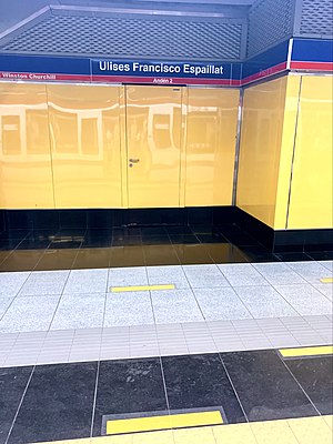
Ulises Francisco Espaillat metro station
Santo Domingo metro station
Distance: Approx. 1692 meters
Latitude and longitude: 18.48202778,-69.94663889
Ulises Francisco Espaillat is a Santo Domingo Metro station on Line 2. It was open on 1 April 2013 as part of the inaugural section of Line 2 between María Montez and Eduardo Brito. The station is located between Francisco Gregorio Billini and Pedro Mir.

Pedro Mir metro station
Santo Domingo metro station
Distance: Approx. 1045 meters
Latitude and longitude: 18.48372222,-69.94077778
Pedro Mir is a Santo Domingo Metro station on Line 2. It was open on 1 April 2013 as part of the inaugural section of Line 2 between María Montez and Eduardo Brito. The station is located between Ulises Francisco Espaillat and Freddy Beras Goico.

Freddy Beras Goico metro station
Santo Domingo metro station
Distance: Approx. 394 meters
Latitude and longitude: 18.48263889,-69.93197222
Freddy Beras Goico is a Santo Domingo Metro station on Line 2. It was open on 1 April 2013 as part of the inaugural section of Line 2 between María Montez and Eduardo Brito. The station is located between Pedro Mir and Juan Ulises García Saleta.
Juan Ulises García Saleta metro station
Santo Domingo metro station
Distance: Approx. 1232 meters
Latitude and longitude: 18.48194444,-69.92038889
Juan Ulises García Saleta is a Santo Domingo Metro station on Line 2. It was open on 1 April 2013 as part of the inaugural section of Line 2 between María Montez and Eduardo Brito. The station is located between Freddy Beras Goico and Juan Pablo Duarte.
Weather in this IP's area
scattered clouds
32 Celsius
39 Celsius
32 Celsius
33 Celsius
1010 hPa
70 %
1010 hPa
1004 hPa
10000 meters
3.6 m/s
60 degree
40 %
06:28:23
18:37:40