Country:
Region:
City:
Latitude and Longitude:
Time Zone:
Postal Code:
IP information under different IP Channel
ip-api
Country
Region
City
ASN
Time Zone
ISP
Blacklist
Proxy
Latitude
Longitude
Postal
Route
Luminati
Country
ASN
Time Zone
America/Chicago
ISP
ATGS-MMD-AS
Latitude
Longitude
Postal
IPinfo
Country
Region
City
ASN
Time Zone
ISP
Blacklist
Proxy
Latitude
Longitude
Postal
Route
db-ip
Country
Region
City
ASN
Time Zone
ISP
Blacklist
Proxy
Latitude
Longitude
Postal
Route
ipdata
Country
Region
City
ASN
Time Zone
ISP
Blacklist
Proxy
Latitude
Longitude
Postal
Route
Popular places and events near this IP address

Belén (canton)
Canton in Heredia province, Costa Rica
Distance: Approx. 2570 meters
Latitude and longitude: 9.9854406,-84.1768586
Belén is the seventh canton in the Heredia province of Costa Rica. The head city is in San Antonio district. It is part of the Greater Metropolitan Area, where the housing area constitutes at least 25% of the canton's surface.
Flores (canton)
Canton in Heredia province, Costa Rica
Distance: Approx. 2058 meters
Latitude and longitude: 10.0058345,-84.1538838
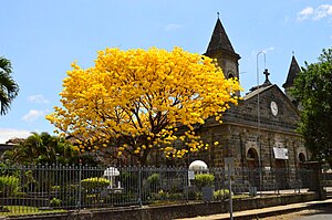
Flores is a canton in the Heredia province of Costa Rica. The head city is in San Joaquín district.

San Joaquín de Flores
District in Flores canton, Heredia province, Costa Rica
Distance: Approx. 2076 meters
Latitude and longitude: 10.0059992,-84.1538838
San Joaquín is a district of the Flores canton, in the Heredia province of Costa Rica.
American International School of Costa Rica
Distance: Approx. 1940 meters
Latitude and longitude: 9.9737,-84.1645
The American International School of Costa Rica is an American international school in Cariari, La Asunción District, Belén, Heredia Province, Costa Rica. Serving grade levels preschool through 12, the school as of 2015 has 220 students. It was established in 1970.
Mercedes District, Heredia
District in Heredia canton, Heredia province, Costa Rica
Distance: Approx. 3069 meters
Latitude and longitude: 10.0062029,-84.1330732
Mercedes is a district of the Heredia canton, in the Heredia province of Costa Rica.
San Francisco District, Heredia
District in Heredia canton, Heredia province, Costa Rica
Distance: Approx. 1840 meters
Latitude and longitude: 9.9855772,-84.1368109
San Francisco is a district of the Heredia canton, in the Heredia province of Costa Rica.
Ulloa District
District in Heredia canton, Heredia province, Costa Rica
Distance: Approx. 2358 meters
Latitude and longitude: 9.9751375,-84.1359263
Ulloa (Spanish pronunciation: [uˈʝo.a]) is a district of the Heredia canton, in the Heredia province of Costa Rica.
La Asunción District
District in Belén canton, Heredia province, Costa Rica
Distance: Approx. 1599 meters
Latitude and longitude: 9.9788534,-84.1652601
La Asunción is a district of the Belén canton, in the Heredia province of Costa Rica.
Barrantes District
District in Flores canton, Heredia province, Costa Rica
Distance: Approx. 3020 meters
Latitude and longitude: 10.0144801,-84.1534671
Barrantes is a district of the Flores canton, in the Heredia province of Costa Rica.
Llorente District
District in Flores canton, Heredia province, Costa Rica
Distance: Approx. 1328 meters
Latitude and longitude: 9.9972671,-84.1602285
Llorente is a district of the Flores canton, in the Heredia province of Costa Rica.
La Ribera District
District in Belén canton, Heredia province, Costa Rica
Distance: Approx. 3206 meters
Latitude and longitude: 9.9938512,-84.1819931
La Ribera, also spelled La Rivera, just Ribera or Rivera, is a district of the Belén canton, in the Heredia province of Costa Rica.
The Church of Jesus Christ of Latter-day Saints in Costa Rica
Distance: Approx. 3436 meters
Latitude and longitude: 9.986418,-84.184831
The Church of Jesus Christ of Latter-day Saints in Costa Rica refers to the Church of Jesus Christ of Latter-day Saints (LDS Church) and its members in Costa Rica. The first branch was organized in 1950. As of December 31, 2022, there were 53,234 members in 78 congregations in Costa Rica.
Weather in this IP's area
broken clouds
22 Celsius
22 Celsius
21 Celsius
23 Celsius
1014 hPa
81 %
1014 hPa
900 hPa
10000 meters
1.03 m/s
120 degree
75 %
05:29:42
17:11:35
