Country:
 Colombia
Region:
City:
Latitude and Longitude:
Time Zone:
Postal Code:
IP information under different IP Channel
ip-api
Country
Region
City
ASN
Time Zone
ISP
Blacklist
Proxy
Latitude
Longitude
Postal
Route
IPinfo
Country
Region
City
ASN
Time Zone
ISP
Blacklist
Proxy
Latitude
Longitude
Postal
Route
MaxMind
Country
Region
City
ASN
Time Zone
ISP
Blacklist
Proxy
Latitude
Longitude
Postal
Route
Luminati
Country
CORegion
bol
City
cartagena
ASN
Time Zone
America/Bogota
ISP
ATGS-MMD-AS
Latitude
Longitude
Postal
db-ip
Country
Region
City
ASN
Time Zone
ISP
Blacklist
Proxy
Latitude
Longitude
Postal
Route
ipdata
Country
Region
City
ASN
Time Zone
ISP
Blacklist
Proxy
Latitude
Longitude
Postal
Route
Popular places and events near this IP address

Cartagena, Colombia
City in coastal northern Colombia
Distance: Approx. 2927 meters
Latitude and longitude: 10.4,-75.5
Cartagena ( KAR-tə-HAY-nə), known since the colonial era as Cartagena de Indias (Spanish: [kaɾtaˈxena ðe ˈindjas] ), is a city and one of the major ports on the northern coast of Colombia in the Caribbean Coast Region, along the Caribbean sea. Cartagena's past role as a link in the route to the West Indies provides it with important historical value for world exploration and preservation of heritage from the great commercial maritime routes. As a former Spanish colony, it was a key port for the export of Bolivian silver to Spain and for the import of enslaved Africans under the asiento system.

Bolívar Department
Department of Colombia
Distance: Approx. 2927 meters
Latitude and longitude: 10.4,-75.5
Bolívar (Spanish pronunciation: [boˈliβaɾ]) is a department of Colombia. It was named after one of the original nine states of the United States of Colombia. It is located to the north of the country, extending roughly north–south from the Caribbean coast at Cartagena near the mouth of the Magdalena River, then south along the river to a border with Antioquia Department.

Raid on Cartagena de Indias (1697)
French attack during the War of the Grand Alliance
Distance: Approx. 1446 meters
Latitude and longitude: 10.4114,-75.535
The raid on Cartagena de Indias was a successful attack by the French on the fortified city of Cartagena de Indias, on 6 May 1697, as part of the War of the Grand Alliance.

Battle of Cartagena de Indias
1741 naval battle of the War of Jenkins' Ear
Distance: Approx. 2210 meters
Latitude and longitude: 10.38527778,-75.53861111
The Battle of Cartagena de Indias (Spanish: Sitio de Cartagena de Indias, lit. 'Siege of Cartagena de Indias') took place during the 1739 to 1748 War of Jenkins' Ear between Spain and Great Britain. The result of long-standing commercial tensions, the war was primarily fought in the Caribbean; the British tried to capture key Spanish ports in the region, including Porto Bello and Chagres in Panama, Havana, and Cartagena de Indias in present-day Colombia. Two previous naval attacks in 1740 had failed and for the third attempt in March 1741, the British had opted for a combined naval and land attack.
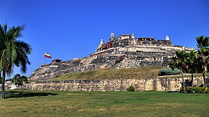
Castillo San Felipe de Barajas
Fortress in Cartagena, Colombia
Distance: Approx. 2728 meters
Latitude and longitude: 10.4225,-75.5392
The Castillo San Felipe de Barajas (San Felipe de Barajas Castle) is a fortress in the city of Cartagena, Colombia. The castle was built in 1639 and is located on the Hill of San Lázaro in a strategic location, dominating approaches to the city by land or sea. It was originally known as the Castillo de San Lázaro.
Capture of the galleon San Joaquin
1711 naval battle
Distance: Approx. 1446 meters
Latitude and longitude: 10.4114,-75.535
The capture of the galleon San Joaquin or the battle of Cartagena was a naval engagement that took place off the coast near Cartagena (present day Colombia). It involved five British ships of the line against the Spanish galleon San Joaquin and a smaller ship. After an action lasting barely an hour the Spanish ship surrendered.

Battle of Cartagena de Indias (1586)
Part of the Anglo-Spanish War
Distance: Approx. 2728 meters
Latitude and longitude: 10.4225,-75.5392
The Battle of Cartagena de Indias (1586) or the Capture of Cartagena de Indias was a military and naval action fought on 9–11 February 1586, of the recently declared Anglo-Spanish War that resulted in the assault and capture by English soldiers and sailors of the Spanish colony city of Cartagena de Indias (now part of Colombia) governed by Pedro de Bustos on the Spanish Main. The English were led by Francis Drake. The raid was part of his Great Expedition to the Spanish New World.

Convento de la Popa
Distance: Approx. 1997 meters
Latitude and longitude: 10.4192,-75.5255
The convent, cloister and chapel of Nuestra Señora de la Candelaria de la Popa are located at the top of Mount la Popa, in Cartagena de Indias, in Colombia. It is also called Convento de Santa Cruz de la Popa.

San Sebastián del Pastelillo Fort
Military fortress in Cartagena de Indias, Colombia
Distance: Approx. 2346 meters
Latitude and longitude: 10.414088,-75.543736
The Fort San Sebastián del Pastelillo (Spanish: Fuerte de San Sebastián del Pastelillo) is a military fortress built in colonial times in Cartagena de Indias, Colombia.

Old Boots (sculpture)
Sculptures located in Cartagena, Colombia and Coral Gables, Florida, United States
Distance: Approx. 2525 meters
Latitude and longitude: 10.42128,-75.53762
Old Boots (Spanish: Las Botas Viejas), also known as the Old Shoes Monument (Spanish: Monumento Los Zapatos Viejos) is a sculpture located in Cartagena, Colombia. The statue was created in honor of Colombian poet Luis Carlos López, who, in his poem A mi Ciudad Nativa, compared the city of Cartagena to a pair of old boots.

Siege of Cartagena (1815)
Part of the Colombian War of Independence
Distance: Approx. 2927 meters
Latitude and longitude: 10.4,-75.5
The Siege of Cartagena (1815) (Spanish: Asedio español de Cartagena de Indias) was a successful 105-day Spanish siege by combined naval and ground forces under command of General Pablo Morillo, of the Colombian city and fortress of Cartagena de Indias, defended by Republican forces under the leadership of Manuel del Castillo y Rada and José Francisco Bermúdez, between August and December 1815.
Siege of Cartagena (1820–21)
Part of the Colombian War of Independence
Distance: Approx. 2927 meters
Latitude and longitude: 10.4,-75.5
The Siege of Cartagena (1820–1821) (Spanish: Asedio de Cartagena de Indias (1820–1821)) was a military confrontation fought in the context of the Colombian War of Independence between Patriots and Royalists, with the victory of the former. It was the longest siege experienced by the city in its history.
Weather in this IP's area
few clouds
30 Celsius
37 Celsius
30 Celsius
30 Celsius
1009 hPa
85 %
1009 hPa
1008 hPa
10000 meters
5.14 m/s
210 degree
20 %
05:51:25
17:59:24