Country:
 USA
USARegion:
City:
Latitude and Longitude:
Time Zone:
Postal Code:
IP information under different IP Channel
ip-api
Country
Region
City
ASN
Time Zone
ISP
Blacklist
Proxy
Latitude
Longitude
Postal
Route
IPinfo
Country
Region
City
ASN
Time Zone
ISP
Blacklist
Proxy
Latitude
Longitude
Postal
Route
MaxMind
Country
Region
City
ASN
Time Zone
ISP
Blacklist
Proxy
Latitude
Longitude
Postal
Route
Luminati
Country
USASN
Time Zone
America/Chicago
ISP
ATGS-MMD-AS
Latitude
Longitude
Postal
db-ip
Country
Region
City
ASN
Time Zone
ISP
Blacklist
Proxy
Latitude
Longitude
Postal
Route
ipdata
Country
Region
City
ASN
Time Zone
ISP
Blacklist
Proxy
Latitude
Longitude
Postal
Route
Popular places and events near this IP address
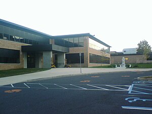
New School High School of Monmouth County
Distance: Approx. 2733 meters
Latitude and longitude: 40.421452,-74.142673
New School High School of Monmouth County (NSHS) was a high school in the Monmouth County area of New Jersey that opened in 1998, notable for its style of alternative education until its closure in 2004. The New School of Monmouth County High School Founded by former public school teacher Dale Thompson and the daughter of one of the founders of the original New School elementary school, Rebekah Chilvers, the New School High School marked a radical departure from traditional educational philosophy. The New School tenets were drawn from a variety of British alternative teaching practice known as "open-classroom." Rather than relying on tests and grades to measure student progress, the New School High School or NSHS abolished these practices and instead centered on individualized learning centered on all-encompassing yearly themes.

Evil Clown of Middletown
Monument in Middletown, New Jersey
Distance: Approx. 3161 meters
Latitude and longitude: 40.3917,-74.0991
The Evil Clown of Middletown is a large outdoor sign in Middletown Township, New Jersey. Originally built by and for Food Circus grocery store, which later became known as the regional supermarket Foodtown, it is now a roadside display and de facto advertising sign for a nearby Spirits Liquors. Much of the clown's notoriety stems from its sinister-looking face, which might be described as bearing a vaguely amused sideways scowl.

Raritan High School
High school in Monmouth County, New Jersey, US
Distance: Approx. 3330 meters
Latitude and longitude: 40.424323,-74.152997
Raritan High School is a four-year comprehensive public high school serving students in ninth through twelfth grades from Hazlet Township in Monmouth County, in the U.S. state of New Jersey, operating as the lone secondary school of the Hazlet Township Public Schools. The school was named after the former community name, Raritan Township, and opened in September 1962 with an enrollment of 778 students, increasing to more than 2,300 students by 1979. As of the 2022–23 school year, the school had an enrollment of 838 students and 72.3 classroom teachers (on an FTE basis), for a student–teacher ratio of 11.6:1.
Hazlet Township Public Schools
School district in Monmouth County, New Jersey, US
Distance: Approx. 3321 meters
Latitude and longitude: 40.424273,-74.152874
The Hazlet Township Public Schools is a comprehensive community public school district that serves students in pre-kindergarten through twelfth grade from Hazlet, in Monmouth County, in the U.S. state of New Jersey. As of the 2022–23 school year, the district, comprised of eight schools, had an enrollment of 2,703 students and 247.0 classroom teachers (on an FTE basis), for a student–teacher ratio of 10.9:1. The district is classified by the New Jersey Department of Education as being in District Factor Group "DE", the fifth-highest of eight groupings.
Middletown High School North
High school in Monmouth County, New Jersey, United States
Distance: Approx. 3022 meters
Latitude and longitude: 40.401574,-74.10036
Middletown High School North, home of the Lions, is a four-year comprehensive public high school located in Middletown Township, in Monmouth County, in the U.S. state of New Jersey, serving students in ninth through twelfth grades as one of the two secondary schools of the Middletown Township Public School District. Other students from Middletown Township attend Middletown High School South. The school also houses a 750-seat theater.

Mater Dei High School (New Jersey)
Catholic school in Monmouth County, New Jersey, US
Distance: Approx. 3305 meters
Latitude and longitude: 40.4151,-74.1042
Mater Dei Prep: A Catholic Preparatory School (commonly known as "Mater Dei High School") was a four-year Catholic coeducational high school that served students in ninth through twelfth grades, located in the New Monmouth section of Middletown Township, in Monmouth County, in the U.S. state of New Jersey. Mater Dei used to be a part of St. Mary Parish and later operated under the supervision of the Roman Catholic Diocese of Trenton.

Middletown station (NJ Transit)
NJ Transit rail station
Distance: Approx. 1913 meters
Latitude and longitude: 40.38939167,-74.11570556
Middletown is a passenger railway station for New Jersey Transit's North Jersey Coast Line in Middletown Township, Monmouth County, New Jersey. Located along both sides of Church Street in Middletown, the station is the only active station within the township.

New Monmouth, New Jersey
Populated place in Monmouth County, New Jersey, US
Distance: Approx. 3173 meters
Latitude and longitude: 40.41194444,-74.10333333
New Monmouth is an unincorporated community located within Middletown Township in Monmouth County, in the U.S. state of New Jersey. The area is served as United States Postal Service ZIP Code 07748. As of the 2010 United States Census, the population for ZIP Code Tabulation Area 07748 was 28,030.
Mahoras Brook
River in the United States
Distance: Approx. 909 meters
Latitude and longitude: 40.3894,-74.137
Mahoras Brook is an approximately 3.5 miles (5.6 km) long spring-fed tributary of Waackaack Creek that flows through Monmouth County, New Jersey. It rises in a small glen shortly west of Middletown, at 40°25′12″N 74°08′13″W and makes a bend north, flowing through the northwest section of Tatum Park. The creek flows under Holland Road and runs north in a small, forested swale through a dominantly residential area, roughly paralleling Laurel Avenue (County Route 52), and receives a small tributary on the left bank.
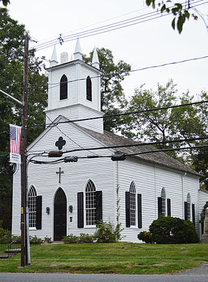
Christ Church (Middletown, New Jersey)
Historic church in New Jersey, United States
Distance: Approx. 1564 meters
Latitude and longitude: 40.39388889,-74.11777778
Christ Church is a historic church in Middletown Township, New Jersey built in 1744.
Middletown Village, New Jersey
Populated place in Monmouth County, New Jersey, US
Distance: Approx. 1602 meters
Latitude and longitude: 40.39416667,-74.11722222
Middletown Village is an unincorporated community located in the central part of Middletown Township, Monmouth County, New Jersey. It was the first settlement in the township and one of the oldest in New Jersey. The Middletown Village Historic District, encompassing the community, was listed on the state and national registers of historic places in 1974.

Deep Cut Gardens
Botanical garden in New Jersey
Distance: Approx. 960 meters
Latitude and longitude: 40.39,-74.13
Deep Cut Gardens is a public botanical garden in Middletown Township, New Jersey. Adjacent to Tatum Park, the 54-acre (22 ha) garden is dedicated to home gardening, and are visited by 100,000 visitors a year. The park features a variety of gardens, including a rockery, a display greenhouse, a rose parterre and a Japanese garden.
Weather in this IP's area
clear sky
24 Celsius
24 Celsius
23 Celsius
26 Celsius
1015 hPa
61 %
1015 hPa
1011 hPa
10000 meters
2.68 m/s
5.81 m/s
79 degree
6 %
06:42:36
18:57:05