31.95.6.243 - IP Lookup: Free IP Address Lookup, Postal Code Lookup, IP Location Lookup, IP ASN, Public IP
Country:
 Great Britain
Region:
City:
Location:
Time Zone:
Postal Code:
ISP:
ASN:
language:
User-Agent:
Proxy IP:
Blacklist:
IP information under different IP Channel
ip-api
Country
Region
City
ASN
Time Zone
ISP
Blacklist
Proxy
Latitude
Longitude
Postal
Route
db-ip
Country
Region
City
ASN
Time Zone
ISP
Blacklist
Proxy
Latitude
Longitude
Postal
Route
IPinfo
Country
Region
City
ASN
Time Zone
ISP
Blacklist
Proxy
Latitude
Longitude
Postal
Route
IP2Location
31.95.6.243Country
gbRegion
england
City
puddle dock
Time Zone
Europe/London
ISP
Language
User-Agent
Latitude
Longitude
Postal
ipdata
Country
Region
City
ASN
Time Zone
ISP
Blacklist
Proxy
Latitude
Longitude
Postal
Route
Popular places and events near this IP address

Blackfriars station
London Underground and railway station
Distance: Approx. 83 meters
Latitude and longitude: 51.5116,-0.103
Blackfriars, also known as London Blackfriars, is a central London railway station and connected London Underground station in the City of London. It provides Thameslink services: local (from North to South London), and regional (Bedford and Cambridge to Brighton) and limited Southeastern commuter services to South East London and Kent. Its platforms span the River Thames, the only station in London to do so, along the length of Blackfriars Railway Bridge, a short distance downstream from Blackfriars Bridge.
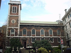
St Andrew-by-the-Wardrobe
Church in London, England
Distance: Approx. 88 meters
Latitude and longitude: 51.51234444,-0.10135833
St Andrew-by-the-Wardrobe is a Church of England church located on Queen Victoria Street, London in the City of London, near Blackfriars station.

Baynard's Castle
Buildings on two neighbouring sites in London
Distance: Approx. 127 meters
Latitude and longitude: 51.51138889,-0.1
Baynard's Castle refers to buildings on two neighbouring sites in the City of London, between where Blackfriars station and St Paul's Cathedral now stand. The first was a Norman fortification constructed by Ralph Baynard (fl. 1086), 1st feudal baron of Little Dunmow in Essex, and was demolished by King John in 1213.

Mermaid Theatre
Former theatre in London, England
Distance: Approx. 35 meters
Latitude and longitude: 51.511306,-0.101972
The Mermaid Theatre was a theatre encompassing the site of Puddle Dock and Curriers' Alley at Blackfriars in the City of London, and the first built in the City since the time of Shakespeare. It was, importantly, also one of the first new theatres to abandon the traditional stage layout; instead of this, a single tier of seats surrounded the stage on three sides.

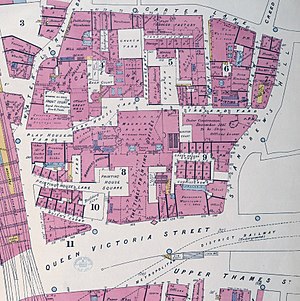
Puddle Dock
Street in Blackfriars in the City of London
Distance: Approx. 68 meters
Latitude and longitude: 51.511,-0.102
Puddle Dock is a street in Blackfriars in the City of London. It was once the site of one of London's docks, and was later the site of the Mermaid Theatre. The dock was filled in during redevelopment in the 1960s and 1970s.

Blackfriars Pier
Pier on the River Thames
Distance: Approx. 100 meters
Latitude and longitude: 51.5107,-0.1017
Blackfriars Pier is a pier on the River Thames, in the Blackfriars area of the City of London, United Kingdom. It is served by boats operated by Uber Boat by Thames Clippers under licence from London River Services and is situated on the north bank of the Thames, adjacent to Blackfriars Bridge. Blackfriars Millennium Pier is a major transport interchange being close to Blackfriars rail and tube station, providing direct interchange with Thameslink and Southeastern rail services, and with the London Underground Circle and District lines.

Fatal Vespers
1623 structural collapse in London, England
Distance: Approx. 83 meters
Latitude and longitude: 51.5116,-0.103
The Fatal Vespers was a 1623 structural collapse at Hunsdon House in Blackfriars, London, England, the official residence of the French ambassador. There were 95 fatalities when the floor of an upper room collapsed under the weight of three hundred people who were attending a Roman Catholic service. Protestant polemicists interpreted the disaster as evidence of divine opposition to Papism.

ChristChurch London
UK Christian church
Distance: Approx. 35 meters
Latitude and longitude: 51.51130556,-0.10197222
Christ Church London (also commonly known as Christ Church; and shorthand CCL), founded 2004, is a Christian church that meets at several locations across London, United Kingdom. As Christians, Christ Church London has a large focus on sharing their faith with non-Christians by building community through holding a large number of social events throughout the year, which allow people to invite friends into the church community. Christ Church London is a multicultural community with attendees from all over the world.

BT Museum
Distance: Approx. 53 meters
Latitude and longitude: 51.51191833,-0.10122333
The BT Museum was a telecommunications museum run by BT, that held artefacts and exhibits on the history of telecommunications in the United Kingdom. It was based in Baynard House in the Blackfriars district of London. It was originally opened as the Telecom Technology Showcase in 1982.

Baynard House, London
Office block in London
Distance: Approx. 53 meters
Latitude and longitude: 51.51191833,-0.10122333
Baynard House is a brutalist office block in Queen Victoria Street in Blackfriars in the City of London, occupied by BT Group. It was built on the site of Baynard's Castle. Most of the land under it is a scheduled monument.
Printing House Square
Distance: Approx. 113 meters
Latitude and longitude: 51.5124717,-0.102632
Printing House Square was a London court in the City of London, so called from the former office of the King's Printer which occupied the site. For many years, the office of The Times stood on the site, until it relocated to Gray's Inn Road and later to Wapping. The site has been completely redeveloped.

The Cockpit, City of London
Pub in the City of London
Distance: Approx. 126 meters
Latitude and longitude: 51.512713,-0.101464
The Cockpit is a circa 1860 pub on St Andrew's Hill, in the City of London, where it meets Ireland Yard. Formerly named The Cock Pit, having hosted cockfights, it became The Three Castles in the mid-19th century. It was given its current name in 1970, after a renovation.
Weather in this IP's area
broken clouds
9 Celsius
7 Celsius
8 Celsius
10 Celsius
1039 hPa
79 %
1039 hPa
1035 hPa
10000 meters
3.09 m/s
240 degree
66 %